
Major Hurricane Hilary is gaining strength and according to meteorologists at the National Hurricane Center in Miami, the powerful storm should even gain additional strength over the next day. The NHC forecast continues to show odds growing of a rare California landfall, and it is possible Hilary may be the strongest tropical cyclone to ever strike California. While the center of the storm will be at or near the California coast, impacts from the storm will spread throughout a large part of the U.S. southwest, creating the potential for a large scale disaster due to excessive amounts of rain which in turn could create epic floods. Places like Los Angeles and San Diego, as well as much of southern California, Nevada, and western Arizona could see historic weather conditions unfold in the coming days.
As of the latest advisory from the NHC, Hilary was a major hurricane with winds of 125 mph. Located about 430 miles south of Cabo San Lucas, Mexico, the storm was moving to the west-northwest at 14 mph. Minimum central pressure is down to 952 mb or 28.12″.

For now, many Tropical storm Watches and Warnings are in effect for Mexico but none are in effect for the United States yet. A Tropical Storm Warning is in effect for Baja California Sur Mexico from Cabo San Lazaro southward and for Baja California Sur Mexico from Los Barriles southward; a Tropical Storm Watch is in effect for north of Cabo San Lazaro to Punta Abreojos and for the area north of Los Barriles to Loreto. A Tropical Storm Warning means that tropical storm conditions are expected somewhere within the warning area within 36 hours, while a Tropical Storm Watch means that tropical storm conditions are possible within the watch area, generally within 48 hours.
A Hurricane Watch has also been issued; it is in effect for Baja California Sur north of Punta Abreojos to Punta Eugenia. A Hurricane Watch means that hurricane conditions are possible within the watch area; it is typically issued 48 hours before the anticipated first occurrence of tropical-storm force winds and conditions that make outside preparations difficult or dangerous.
While Hilary is moving to the west-northwest for now, the NHC expects it to take a turn toward the northwest Friday morning, followed by a turn toward the north-northwest and north on Saturday. On the forecast track, the center of Hilary will approach the Baja California peninsula over the weekend. As it moves closer to the Mexican coast, the NHC also expects the storm to gain strength. Hilary is now a category 3 hurricane on the Saffir-Simpson Hurricane Wind Scale. Additional rapid strengthening is forecast during the next day or so, and Hilary is likely to become a category 4 hurricane tomorrow.

Once it moves up the Baja coast, a landfall with southern California is becoming more likely. With cold waters along the Pacific coast and atmospheric ingredients usually preventing storms from approaching California, it is very rare for tropical cyclones or even their remnants to advance to southern California. Since 1950, only four systems made it to the California coast: Jen-Kath in 1968, Hyacinth in 1972, Doreeen in 1977, and Norman in 1978. Those systems made it as remnants; according to the National Weather Service’s Los Angeles office, a storm on September 25th, 1939 is the only time a tropical storm made landfall in California in the 20th Century.
Landfall occurs when the center of a tropical cyclone completely crosses over land from the ocean. While only 1 tropical cyclone made landfall and several others entered California as remnant systems, remnant moisture from tropical cyclones that strike Mexico do make their way into the U.S. southwest often. However, with a landfall, winds are stronger and precipitation could be much heavier; as such, the possibility of a California landfall would be both historic and potentially catastrophic.
 
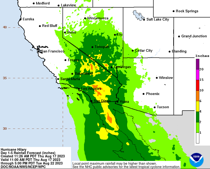
According to the Los Angeles office of the National Weather Service, both Los Angeles and San Diego may see 2-4″ of rain. Both of these communities rarely see heavy rain and previous storms dropping a fraction of this amount have created big headaches for the region. With homes lacking gutters and streets lacking storm drains due to generally arid conditions, flood problems and water damage could be quite significant here. The normal seasonal rainfall measured at downtown Los Angeles is 14.77″ 92% of which between November 1 and April 30. If Los Angeles gets just 20% of an annual rainfall within a 24-36 hour period, flooding could be great.
Hurricane #Hilary will bring a variety of problems to the coast and inland to California. Whether you're on land or nearby at sea, make sure you follow this unique storm and its developments! #CAwx https://t.co/ZhvF8W75uG
— the Weatherboy (@theWeatherboy) August 18, 2023
Damaging winds are also possible in southern California should the storm hit as a tropical storm. In the latest forecast track from the National Hurricane Center, the center of Hilary is forecast to track along the coast of the Baja California and make landfall somewhere between Los Angeles and San Diego. While the specific track is likely to change in the coming days and people should be concerned about the general track of the greater storm and not simply its center, such a track would lash a large area that doesn’t ordinarily see strong winds with tropical storm force sustained winds and perhaps even higher gusts.
As a result of the forecast, people across southern California, as well as Nevada and Arizona, are urged to have a Hurricane Action Plan. It may become necessary as soon as Friday to execute it, especially with the threat of a widespread flooding rain disaster growing in a part of the nation that doesn’t get much rain, especially at this time of the year.
