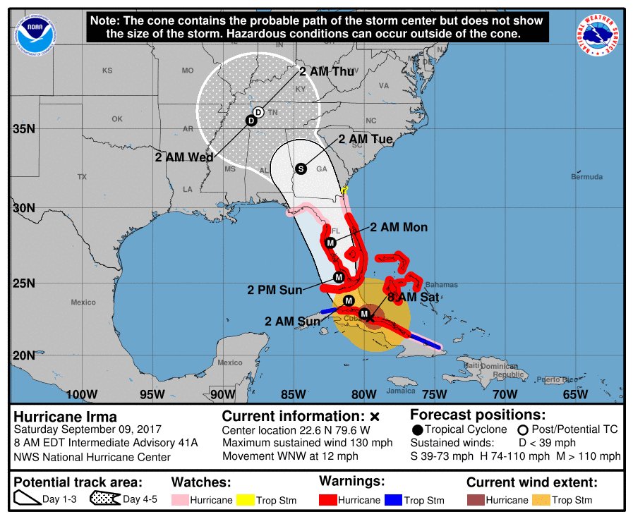
The catastrophic destruction of southwest Florida is imminent as Major Hurricane Irma appears to be on a collision course with the peninsula. It is likely that the westernmost Florida Keys, Marco Island, Naples, Bonita Springs, Fort Meyers, Cape Coral, Sanibel Island, Captiva Island, and Pine Island will bear the brunt of this devastating, deadly storm. Irma is forecast to strike the state as a Category 4 or 5 hurricane, bringing with it a variety of hazards: historic storm surge, dozens of tornadoes, flooding rains, and of course, destructive winds.
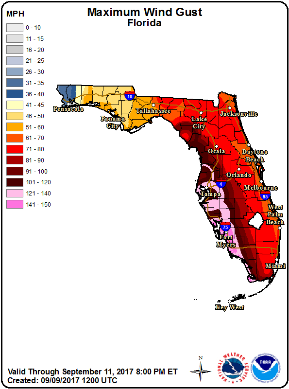
The entire Peninsula will be hit hard by damaging winds near or above hurricane strength. Winds will gust greater than 75mph in Jacksonville, St. Augustine, Daytona Beach, Titusville, Melbourne, and West Palm Beach. Winds could gust above 85mph in Ft. Lauderdale and Miami.
The most destructive winds, though, will be over western parts of the state where the eye wall of Irma is expected to push through. Here, sustained winds over 100mph are likely with gusts over 150mph possible, with Fort Meyers metro region forecast to be ground zero for the storm’s worst. The risk of wind damage extends far north up the Florida west coast and includes the Tampa metro region too. Damaging winds are also likely around Orlando, including the theme park areas south of the city.
The Fort Meyers metro region appears to be ground zero for Irma’s ferocity, with historic storm surge likely overwhelming Sanibel and Captiva Islands, much of Cape Coral, and all of Fort Meyers Beach. A catastrophic storm surge may extend far inland, especially in Cape Coral, helped along by the man made canal system there. The Gulf of Mexico may be as far inland as Veteran’s Parkway and Chiquita Boulevard there. Sanibel Island is forecast to be completely submerged by the storm surge and some of the water there may be more than one story deep; the same is true for Fort Meyers beach, where we expect a complete inundation. Major Hurricane Irma’s current trajectory is a worst case scenario for this part of the state when it comes to storm surge damage.
The Florida panhandle is not immune to impacts from Hurricane Irma either. Strong, potentially damaging wind gusts are possible along much of the Gulf Coast; Panama City and Tallahassee could see quite a lot of wind damage from this storm. The panhandle, especially around the Apalachee Bay, may be extremely vulnerable to storm surge, especially if Irma wobbles more west than currently forecast.
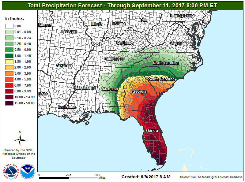
Beyond wind and storm surge, rain will be extremely heavy state-wide, creating life-threatening flash flood conditions. More than 20″ of rain is possible across southwestern and northeastern Florida, with the heaviest rain expected over Sarasota to Key West on the southwestern portion of the state. While little to no rain is expected near Pensacola, flooding could be problematic across Lake City, Jacksonville, Ponte Vedra, and St. Augustine. The heavy rain and flood threat extends beyond Florida too; Georgia and South Carolina will each see extremely heavy rains as this storm moves north through the Sunshine State.
Widespread tornadoes are expected throughout the entire Florida Peninsula and into southern Georgia and South Carolina. There could be more than 100 tornadoes associated with this landfall situation.
Expect catastrophic destruction and long term problems from the catastrophe: no utilities, water, food, or fuel for weeks if not months. It will take a long time to make some parts of Florida habitable again. Even if people survive in their homes, they will find their neighborhoods cut off from civilization for potentially a long period of time, especially in mandatory evacuation areas in southwest Florida. With all of these potential and likely threats, a slew of watches and warnings are up.
A Storm Surge Warning is in effect for:
- Volusia/Brevard County Line southward around the Florida peninsulat o Chassahowitzka
- Florida Keys
- Tampa Bay
A Storm Surge Watch is in effect for:
- North of the Volusia/Brevard County Line to the Flagler/Volusia County line
- North of Chassahowitzka to Suwannee River
A Hurricane Warning is in effect for:
- Flagler/Volusia County Line southward around the Florida peninsula to Chassahowitzka
- Florida Keys
- Lake Okeechobee
- Florida Bay
- Cuban provinces of Camaguey, Ciego de Avila, Sancti Spiritus, Villa Clara, and Matanzas
- Northwestern Bahamas
A Hurricane Watch is in effect for:
- North of the Flagler/Volusia County Line to Fernandina Beach
- North and west of Chassahowitzka to Indian Pass
- Cuban provinces of Holguin and Las Tunas
A Tropical Storm Warning is in effect for:
- Cuban provinces of Holguin, Las Tunas, La Habana, and Ciudad de la Habana
A Tropical Storm Watch is in effect for:
- North of Fernandina Beach to Altamaha Sound
A Storm Surge Warning means there is a danger of life-threatening inundation, from rising water moving inland from the coastline, during the next 36 hours in the indicated locations. This is a life-threatening situation. Persons located within these areas should take all necessary actions to protect life and property from rising water and the potential for other dangerous conditions. Promptly follow evacuation and other instructions from local officials. A Storm Surge Watch means there is a possibility of life-threatening inundation, from rising water moving inland from the coastline, in the indicated locations during the next 48 hours.
A Hurricane Warning means that hurricane conditions are expected somewhere within the warning area. Preparations to protect life and property should be rushed to completion.
A Hurricane Watch means that hurricane conditions are possible within the watch area. A watch is typically issued 48 hours before the anticipated first occurrence of tropical-storm-force winds, conditions that make outside preparations difficult or dangerous.
A Tropical Storm Warning means that tropical storm conditions are expected somewhere within the warning area.
A Tropical Storm Watch means that tropical storm conditions are possible within the watch area, generally within 48 hours.
