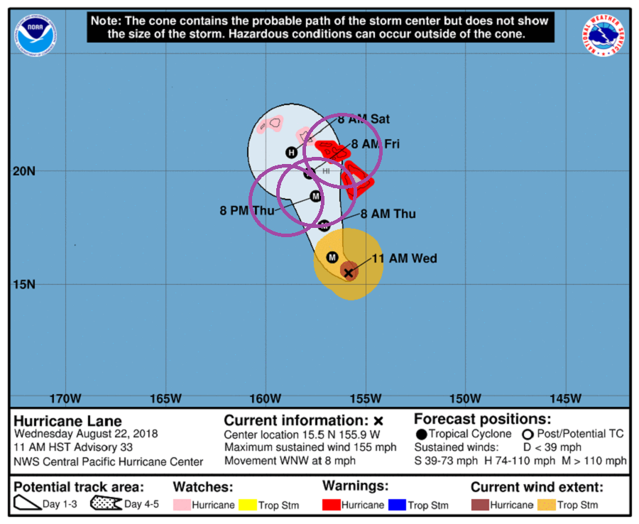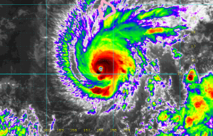
Major Hurricane Lane, a high-end Category 4 hurricane with 155mph sustained winds just 2mph shy of Category 5 status, is inching closer to Hawaii, where severe impacts are expected tomorrow. As of the last briefing from the Central Pacific Hurricane Center (CPHC) at 11am HT / 5pm ET, the eye of Hurricane Lane was located near latitude 15.5 North, longitude 155.9 West. Lane is moving toward the west-northwest near 8 mph. The CPHC expects a gradual turn
toward the northwest today followed by a more northward motion on Thursday. A turn back toward the west is forecast to occur on Saturday. Based on the CPHC forecast, the center of Lane will move very close to or over the main Hawaiian Islands from Thursday through Saturday.

It is important to point out that impacts from a hurricane extend well beyond its center. While the CPHC forecast map shows a cone of where the center can travel, it does not reflect the broader wind field and rain shield around the storm. At this time, Lane’s hurricane-force winds extend outward up to 40 miles from the center and tropical-storm-force winds extend outward up to 140 miles. It is possible the wind field of Lane will expand as it nears Hawaii.
Based on its air pressure in the surface, Lane became the most intense hurricane recorded in the central Pacific yesterday when it reached Category 5 status. It remains the strongest hurricane to pass this close to Hawaii on record. The estimated minimum central pressure now is 935 mb or 27.61 inches.
Major Hurricane Lane continues to be steered toward the west-northwest by a deep layer ridge to the northeast of the tropical cyclone. According to the CPHC, by about 36 hours, the ridge is expected begin building to the southeast and south of Lane, which will begin to impart a more northward motion through at least 48 hours. By 72 hours, the track guidance begins to show a leftward turn, as the low level circulation of Lane decouples in the face of 35 to 40 kt of shear. Exactly when this critical turn will happen is very difficult to forecast; CPHC says “confidence in this portion of the track is unfortunately rather low.” They add, “However, our most reliable global models, the ECMWF and GFS, suggest this may happen a little later than previously forecast. Thus, the track forecast has been shifted to the northeast between 48 and 72 hours to be in better agreement with the global models.
On the forecast track, Major Hurricane Lane is forecast to pass dangerously close to the main Hawaiian Islands but have no landfall. Nevertheless, because the dangers do extend far beyond the center, severe weather is expected throughout the Aloha State from this hurricane.
The CPHC is sharing three key messages with the community:
- Lane is forecast to move dangerously close to the main Hawaiian Islands as a hurricane tomorrow through Saturday, potentially bringing damaging winds. As Lane will be slow-moving as it nears the islands, prolonged heavy rainfall and life-threatening flash flooding will be possible. Large and damaging surf can be expected along exposed shorelines, along with localized storm surge.
- As Lane approaches the islands from the southeast, initial impacts will be felt on the Big Island and Maui County, where a Hurricane Warning is in effect. Impacts on Kauai County and Oahu are also possible, and a Hurricane Watch is in effect there.
- Do not focus on the exact forecast track or intensity for Lane, and be prepared for adjustments to the forecast. Life threatening impacts can extend well away from the center of a hurricane.
Expected Imacts
Hurricane Lane will impact Hawaii with increasing intensity in the coming hours. The onset of damaging tropical-storm-force winds on the Big Island could start later this evening, with dangerous hurricane force winds starting in the overnight hours. In Maui County, damaging winds could begin as early as Thursday afternoon, with dangerous hurricane force winds possible starting on Thursday night. On Oahu, damaging winds could begin as early as Thursday evening, with dangerous hurricane force winds possible by Friday morning. Hurricane Warnings may need to be expanded to include other islands as Lane draws closer.
Heavy rain is likely from the storm throughout the state. Excessive rainfall is possible which could lead to deadly flash flooding, landslides and mudslides. Flooding can occur even in areas not usually prone to flooding. Storm total rainfall amounts greater than 20 inches are possible. Know what to do with/in floods before they strike.
Swell generated by Lane will produce very large and rough surf, with dangerous rip currents along south, southeast and southwest facing shores.
Tornadoes and large waterspouts will be possible associated with Lane, mainly along and to the right of the track of the hurricane. Because Hawaii is to the right of the system, it is vulnerable to this threat.
FLOODING RAIN
Protect against life-threatening rainfall flooding having possible devastating impacts across the Hawaiian islands. Potential impacts include:
- Extreme rainfall flooding may prompt numerous evacuations and rescues.
Rivers and tributaries may overwhelmingly overflow their banks in many places with deep moving water. Small streams, creeks, canals, arroyos, and ditches may become raging rivers. In mountain areas, deadly runoff may rage down valleys while increasing susceptibility to rockslides and mudslides. Flood control systems and barriers may become stressed. - Flood waters can enter numerous structures within multiple communities, some structures becoming uninhabitable or washed away. Numerous places where flood waters may cover escape routes. Streets and parking lots become rivers of raging water with underpasses submerged. Driving conditions become very dangerous. Numerous road and bridge closures with some weakened or washed out.
WIND
Protect against life-threatening wind having possible extensive impacts across Maui County, Oahu, and western and southern sections of the Big Island. There are possible significant impacts across the northern and eastern sections of the Big Island and Kauai too. Potential impacts in this area include:
- Considerable roof damage to sturdy buildings, with some having window, door, and garage door failures leading to structural damage. Mobile homes severely damaged, with some destroyed. Damage accentuated by airborne projectiles. Locations may be uninhabitable for weeks.
- Many large trees snapped or uprooted along with fences and roadway signs blown over.
- Some roads impassable from large debris, and more within urban or heavily wooded places. Several bridges, causeways, and access routes impassable.
- Large areas with power and communications outages.
SURGE:
Protect against life-threatening surge having possible significant impacts across south and west facing coasts. Potential impacts in this area include:
- Areas of inundation with storm surge flooding accentuated by waves. Damage to several buildings, mainly near the coast.
- Sections of near-shore escape routes and secondary roads become weakened or washed out, especially in usually vulnerable low spots.
- Major beach erosion with heavy surf breaching dunes. Strong and numerous rip currents.
- Moderate damage to marinas, docks, boardwalks, and piers. Several small craft broken away from moorings, especially in unprotected anchorages.
- Elsewhere across the Hawaiian islands, little to no impact is anticipated
TORNADO:
Protect against a tornado event having possible limited impacts across the Hawaiian islands. Potential impacts include:
- The occurrence of isolated tornadoes can hinder the execution of emergency plans during tropical events.
- A few places may experience tornado damage, along with power and communications disruptions.
- Locations could realize roofs peeled off buildings, chimneys toppled, mobile homes pushed off foundations or overturned, large tree tops and branches snapped off, shallow-rooted trees knocked over, moving vehicles blown off roads, and small boats pulled from moorings.