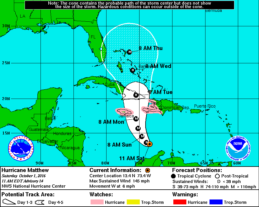
Hurricane Matthew remains a potent major hurricane in the Caribbean, with maximum sustained winds of 155mph according to this morning’s advisory from the National Hurricane Center. Some fluctuations in strength are expected over the next 48 hours as Matthew goes through an eye replacement cycle. On its forecast track, Matthew would bring a catastrophic impact to portions of Jamaica, Haiti, and Cuba. Beyond that, eyes are on the Bahamas and the United States east coast for future possible impacts.
Intensity guidance was off significantly yesterday as Matthew went through a period of explosive intensification. While forecast models suggested the storm wouldn’t grow much, with some remote models suggesting a maximum intensification up to Category 3 strength, Matthew exceeded all forecasts and became a Category 5 monster Friday evening with wind gusts just shy of 200mph. With intensity guidance so far off, meteorologists are concerned that the future track guidance may be off too.
Forecast guidance has been calling for a westward movement of the storm for the last few days, with a sharp turn to the north expected this weekend. While the storm has been moving west, there has also been a somewhat unexpected southerly component to that westward travel. So much so that advisories for the tropical cyclone had to be issued for Aruba, Curaco, and portions of the South American coastline.
As of the morning advisory from the National Hurricane Center, Major Hurricane Matthew is moving due west. Now meteorologists wait to see when it’ll make a turn to the north –how soon or how late it does so has massive impacts to the forecast for the Caribbean and for the east coast of the United States. Matthew remains south of a low-to mid-level ridge over the western Atlantic. The dynamic models forecast this ridge to weaken over the next 72 hours as a mid- to upper-level trough develops over the Gulf of Mexico. This evolution should cause Matthew to turn northwestward after 24 hours and northward by 48-72 hours. The guidance generally agrees with this scenario. However, there is a spread between the American GFS forecast of landfall in Jamaica and eastern Cuba and the European ECMWF forecast landfall in southwestern Haiti.
Either solution from the American and European forecast models is bad. Haiti is one of the poorest countries in the Western Hemisphere with extremely low standards of housing and structure stability. With many people living in shoddy shacks, tents, or otherwise poorly constructed dwellings, an impact here of anything greater than Category 1 hurricane strength would be catastrophic. When Hurricane Sandy hit Haiti in 2012, it left more than 200,000 people homeless. An impact by Matthew at its current intensity would see that number increase significantly, perhaps by more than double. Jamaica, a popular tourist destination for Americans, also has poor construction standards and a population generally poor in substandard housing. While not nearly as bad as Haiti, an impact in Jamaica could be very bad. Hurricane Sandy hit Jamaica as a Category 1 storm in October 2012 and created more than $100million in damages. Should Matthew hit head-on as a Category 4 or 5 storm, the loss of property and life would be very significant across the island. A storm path between Jamaica and Haiti would be very bad for both of those countries, but even worse for Cuba which would see a direct hit near Guantanamo Bay and Santiago de Cuba. When Hurricane Sandy hit this area in 2012 as a Category 2 hurricane , it became one of the biggest disasters Cuba ever saw with more than $2billion in destruction. While only 11 were killed by the storm, more than a quarter million people were left homeless: 130,000 homes were badly damaged and more than 15,000 were completely destroyed. Should Major Hurricane Matthew come at Cuba as an even stronger, larger storm than Sandy was, the death and destruction toll could be exponentially worse.
Beyond the impacts to life and property from Matthew, Cuba and Haiti will also have impacts on Major Hurricane Matthew. Each nation has rough terrain which will help disrupt the flow of wind around and within the storm system. The longer Matthew needs to travel through rough terrain, the more it’ll weaken; the less time it needs to travel over such terrain, the more likely Matthew will maintain its strength as it approaches the Bahamas. Paths over land also disrupt the number one source of energy for tropical cyclones: warm ocean waters. If Matthew were to slide through the open waters between Haiti and Cuba, the results could be catastrophic for the Turks and Caicos Islands with a very strong hurricane moving through there. If the storm were to travel more west over land over Cuba, a longer trek over rough terrain and away from warm water would almost certainly weaken the storm significantly.
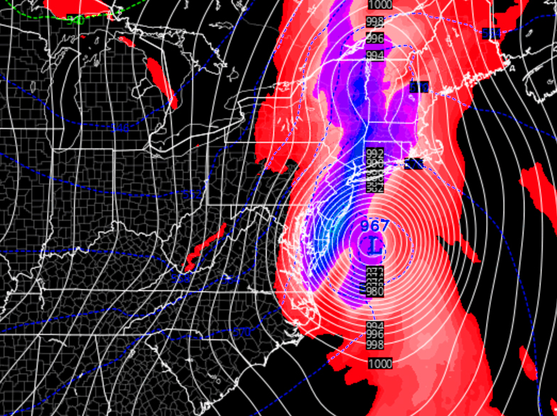
Once Matthew passes through or around Cuba, which is currently forecast to occur on Tuesday, all eyes in the United States will be on Matthew to see how strong it is, how close to the United States it’ll be and/or get, and how much time it’ll have to reorganize and restrengthen over the Bahamas. While Matthew is passing through the Caribbean, a complex weather pattern is unfolding over the eastern United States. A low pressure trough and high pressure ridge will help pull the storm north, but the exact location of that trough and ridge, unknown at this time, will help steer Matthew up the East Coast, into the East Coast, or away from the East Coast. It is also possible that an upper level low over the Great Lakes region or central Canada could even help bring the storm inland over New England and back into eastern Canada, which would create a significant snow storm for portions of Canada if that were to occur.
At this time, the major American GFS and European ECMWF models are split on where Matthew could go, and meteorologists at the National Hurricane Center say it is far too early to know with certainty where Matthew may go next beyond Cuba. If the American model were correct, Matthew would bring significant damage throughout the Bahamas and graze most of the entire US east coast before making landfall near New York or New England next weekend. If the latest European model were to be correct, the storm would be further east, bringing substantial impacts to the Turks and Caicos before potentially impacting Bermuda, saving the US east coast from direct impacts. It is important to note that not only are these solutions very different from each other, but the models themselves have been extremely inconsistent on their own. As an example, just yesterday, the European model suggested that Matthew would stall over the Bahamas for the entire upcoming week. Because the models differ so much from each other and lack run-to-run continuity, there is no confidence in their forecast track beyond 72 hours at this time.
For now, it’ll be a waiting game to see just when and where Matthew makes that turn to the north; traveling further west or cutting earlier and moving a bit east than expected will not only have drastic impacts to the Caribbean, but to the future outcomes associated with this major hurricane.
While it is not yet known whether or not Matthew will have any direct or indirect impacts on the US east coast later next week and weekend, it is important that everyone from Florida to Maine have a Hurricane Action Plan in place just in case Matthew’s eventual track makes it necessary to act on it.
HURRICANE ACTION PLAN
Residents of -any- state that touches the Atlantic Ocean should have a Hurricane Action Plan. In general, you should completely understand where you live, how to identify it on a map, and understand the risks and threats a tropical cyclone brings to your area. If you live on the coastline or offshore islands, plan to leave. If you live near a river or in a flood plain, plan to leave. If you live on high ground, away from coastal beaches, consider staying. In any case, the ultimate decision to stay or leave will be yours. Study the following and carefully consider the factors involved especially the items pertaining to storm surge. As part of your Hurricane Action plan, learn the storm surge history and elevation of your area; learn safe routes inland; learn location of official shelters. If you have a boat, determine where to move it in an emergency. Well before a storm arrives, trim back dead wood from trees, check for loose rain gutters and down spouts, and check shutters should you have them to protect from storms. If your shutters do not protect windows or you have no shutters for your home, be sure to stock boards to cover glass or at least know the size(s) of boards you’d need should a storm threaten your area.Your Hurricane Action Plan should also inform you on what to do when a Hurricane Watch or Warning is issued for your area.
When a Hurricane Watch is issued for your area, check often for official bulletins from the National Hurricane Center and the National Weather Service. Fuel your car, check mobile home tie-downs, moor small craft or decide to move it to safe shelter, stock up on canned amd bottled provisions, check supplies of special medicines and drugs, check batteries for radio and flashlights, secure lawn furniture and other loose material outdoors, tape, board, or shutter windows to prevent shattering, and wedge sliding glass doors to prevent their lifting from their tracks.
When a Hurricane Warning is issued for your area, stay constantly tuned to National Hurricane Center and National Weather Service bulletins. If your home is sturdy and on high ground away from the coast, stay home and board up garage and porch doors; move valuables to upper floors; bring in pets; fill containers (such as a bathtub) with several days supply of drinking water; turn up refrigerator to maximum cold and don’t open unless necessary. In a Hurricane Warning, use phone only for emergencies; stay indoors on the down-wind side of a house away from windows. Be aware of the eye of the hurricane and where your home is in relation to it. If you’re in a mobile home, leave as quickly and as safely as you can. Leave other areas which may be affected by storm tide or stream flooding. Leave early in daylight if possible. If you’re leaving, make sure water and electricity are shut-off at main strations. Take small valuables and papers but travel light. Make a plan for pets: many storm shelters do not allow pets. If you’re evacuating, drive carefully to the nearest designated shelter using recommended evacuation routes. In evacuations, many roads will be closed while others are turned into 1-way highways away from storm danger areas.
As part of your Hurricane Action Planning now, you should walk yourself and your family through what you’d do if a Hurricane Watch or Warning were to be issued for your area. This practice will help inform you of what you need to do when a storm threat actually arrives. Acting smart and calm will save lives and property and being prepared now well in advance of any threat is the most smart thing you can do.
For the latest on Matthew and the rest of the tropics around the US in the Atlantic and the Pacific, visit our Hurricane & Tropical Weather page here: https://weatherboy.com/hurricanes-tropical-weather/
