
Old Man Winter is delivering an unexpected surprise in Easter Baskets today: a winter storm shocker in the northeast with heavy snow likely over the next 24 to 36 hours. With up to a foot of snow expected in portions of the northeast, the National Weather Service has issued Winter Storm Watches for many counties. Even areas where snow isn’t expected will feel more like winter than spring; as such, the National Weather Service has also issued Frost Advisories and Freeze Warnings for a large area too.
The blast of winter weather is being caused by a dramatically different weather pattern; however, things will spring back to spring like conditions in time for the new weekend. High pressure will continue to move across the northern Mid Atlantic tonight, bringing with it a very cold air mass. This high will quickly shift off-shore tomorrow morning, allowing for a potent but fast moving coastal storm to develop and slide up the coast. The storm will develop off the Mid Atlantic Coast tomorrow and race to the north and east, bringing soaking rains to the coastal plain but very heavy wet snow just inland. The snow could be very heavy at times; due to it’s wet consistency, the heavy-falling snowfall may itself be very heavy, causing wires and tree limbs to sag and perhaps fail. The storm will quickly move north and east early Tuesday, with fair but chilly high pressure returning for the middle to later part of the week. This high pressure will shift off-shore too by Friday, allowing for warmer air to return in time for the weekend.
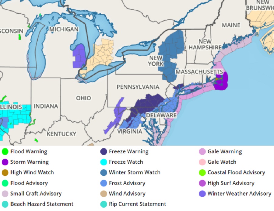
The cold air in place tonight will set the stage for widespread frost and freeze conditions. In places where the growing season has already begun across portions of Pennsylvania, Maryland, Virginia, New Jersey, New York, and Connecticut, Frost Advisories and Freeze Warnings have been issued.
While Winter Weather Advisories are now up for portions of the higher elevations of southwestern Pennsylvania, extreme western Maryland, and eastern West Virginia, Winter Storm Watches have been issued for counties in eastern Upstate New York and northeastern Pennsylvania. Additional watches and warnings could be needed here as this mid-April snowstorm takes shape.
At this time, it appears the heaviest snow will be anchored over eastern Upstate New York west of the Hudson River Valley. In those higher elevations, roughly a foot of heavy wet snow will fall. A pocket of 3-8″ snow is also possible over eastern Michigan and northeastern Ohio. Wet snow will head pretty far south for this time of year; an accumulation of a few inches is possible in portions of eastern Pennsylvania, northern New Jersey, northwestern Connecticut, and western Massachusetts. The heaviest snow should fall late Monday night into early Tuesday morning.
In addition to heavy snow and rain, this compact, quick moving coastal storm will also create windy conditions, especially at the shore. According to the National Weather Service, onshore winds will be quite gusty along the coast with gusts up to 40 mph; these should be less farther inland due to friction and some stabilizing of the low levels of the atmosphere due to precipitation. As the coastal storm exits, conditions will be breezy on Tuesday too; gusts of 30-40 mph from the northwest are possible, especially over coastal areas.
