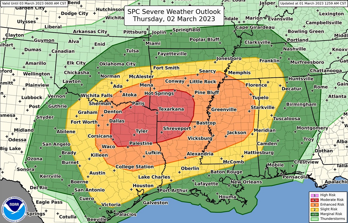
It looks like March is roaring in like a lion with another round of severe weather expected on Thursday. Severe thunderstorms with destructive winds and large, frequent tornadoes are possible again in an area that saw a severe weather outbreak just days ago. The National Weather Service’s Storm Prediction Center (SPC) is warning people to be prepared for this new round of ugly weather. The focus of tomorrow’s severe area threat will be across parts of the southern Plains and into the ArkLaTex and ArkLaMiss regions
According to the SPC, an upper low currently moving through central California is forecast to continue southeastward today before then pivoting eastward tonight and reaching the Arizona/New Mexico border by early Thursday morning. Continued eastward progression across the southern High Plains is anticipated during the day Thursday. A trend towards a negative tilt and a bit more northeastward motion is expected Thursday night into Friday morning as the low moves across the southern Plains.
The surface weather pattern will feature a weak frontal low over the Texas Big Country early Thursday morning, with a warm front extending from this low northeastward through southeast Oklahoma and southern Arkansas. SPC expects this low to progress northeastward along the warm
front into southeast Oklahoma by the afternoon, while a more substantial low develops farther west with the main ascent associated with the upper low. This primary low is then expected to move quickly eastward Thursday evening and overnight, as an attendant cold front sweeps across Texas and the Lower Mississippi Valley.
Ample low-level moisture with surface dewpoints in the mid to upper 60s will be in place across the region ahead of the approaching upper low. Strengthening low to mid-level flow within this moist and buoyant environment will set the stage for numerous severe thunderstorms as the upper low moves through Thursday afternoon into Friday morning.
Thunderstorms will likely be ongoing in the vicinity of the warm front from southwest Texas through the Mid-South. A few stronger storms are possible within this corridor during the morning, but the primary severe threat is expected to begin over the warm sector
Thursday afternoon. Wind profiles throughout the warm sector will support supercells, but warm mid-level temperatures and weak ascent introduce uncertainty regarding the location and coverage of any warm sector storms.
According to the SPC, due to the projected wind profiles, storms that mature should become supercells capable of all severe hazards, including very large hail, strong wind gusts, and tornadoes. A strong tornado is also possible.
A more widespread severe thunderstorm risk is expected to develop across southwest Texas/Texas Big Country during the late afternoon as the front moves through. Strong ascent along the front coupled attendant to the upper low should result in a line of severe storms. This line is forecast to move quickly eastward throughout the evening. Atmospheric dynamics will support both strong wind gusts and embedded tornadoes with this squall line as it moves eastward.
People in this area should be on alert and know what to do and where to go when Severe Thunderstorm Watch and Warnings or Tornado Watch and Warnings are issued.
