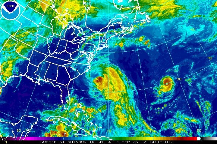
Hurricanes Maria and Lee are heading to open waters today, providing many with a sigh of relief; even better: no new tropical cyclone formation is expected over the next five days. While tropical storm force winds are brushing the Outer Banks of North Carolina, the worst of the wind and rain associated with Maria are far off-shore and will remain there. And while Lee is gaining strength, it is doing so harmlessly over open waters of the Atlantic far from any land mass.
As of the 11am update from the National Hurricane Center (NHC), Hurricane Maria had maximum sustained winds of 75mph, minimum central pressure was 971mb, and it was moving north at 7mph about 175 miles southeast of Cape Hatteras, North Carolina. A Storm Surge Warning has been issued from Ocracoke Inlet to Cape Hatteras; this means there is a danger of life-threatening inundation from rising water moving inland from the coastline. The National Hurricane Center warns, “This is a life-threatening situation. Persons located within these areas should take all necessary actions to protect life and property from rising water and the potential for other dangerous conditions. Promptly follow evacuation and other instructions from local officials.” A Tropical Storm Warning is also in effect for Bogue Inlet to the North Carolina/Virginia border and the Albermarle and Pamlico Sounds. A Storm Surge Watch is up for Cape Lookout to west of Ocracoke Inlet and for areas north of Cape Hatteras to Duck.
Maria is forecast to weaken and head out to sea over time. The NHC believes Maria will weaken to a tropical storm within the next day or two. While weak, it is large. Hurricane-force winds extend outward up to 105 miles from the center and tropical-storm-force winds extend outward up to 240 miles. A NOAA buoy located about 15 miles southeast of Cape Hatteras recently reported a sustained wind of 39 mph with a wind gust to 49 mph.
While Maria lashes the Outer Banks with storm surge flooding and gusty winds, Hurricane Lee continues to spin in the open Atlantic. As of 11:00am , the eye of Hurricane Lee was located near latitude 29.9 North, longitude 53.7 West. Lee is moving toward the west near 10 mph. The hurricane is expected to turn northwestward on Wednesday and northward on Thursday. Maximum sustained winds are near 105 mph with higher gusts. Lee could strengthen a little more before weakening likely begins on Thursday. Lee is a small tropical cyclone; hurricane-force winds only extend outward up to 15 miles from the center and tropical-storm-force winds extend outward up to 45 miles. The estimated minimum central pressure is 975 mb (28.80 inches).
The National Hurricane Center reports no area others of concern in the Atlantic Hurricane Basin; for the next five days, no new tropical cyclone formation is expected.
While the next few days will be quiet, the hurricane season continues and more storms are likely in the weeks ahead.
Experts believe this Atlantic Hurricane Season, which runs through to the end of November, will continue to be a busy one. Dr. Phil Klotzbach and the experts at Colorado State University updated their seasonal outlook again on July 5, showing a much more active than normal season expected. The National Oceanic and Atmospheric Administration (NOAA) also released their own forecast which shows this hurricane season to be likely more active than others.
