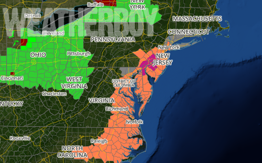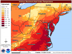
The Mid Atlantic is dealing with a significant blast of heat today, with various heat-related advisories up across a heavily populated area. The worst of it is in the Philadelphia metro region, with Excessive Heat Warnings up from 11am through to 8pm this evening for New Castle county in Delaware, Mercer, Gloucester, Camden, and Burlington counties in New Jersey, and Delaware, Philadelphia, Chester, Montgomery, and Bucks counties in Pennsylvania. In this warning area, the heat index will be in the 99-104 range due to temperatures in the middle 90s and dew points in the upper 60s to low 70s. Beyond that warning area, the National Weather Service has issued Heat Advisories for the New York City metro area, much of the rest of New Jersey, southeastern Pennsylvania, the rest of Delaware, eastern Maryland and Virginia, and much of eastern and southern North Carolina. A Heat Advisory means that a period of high temperatures is expected; the combination of high temperatures and high humidity will create a situation in which heat illnesses are possible. Heat illness is more likely in the warning area. An Excessive Heat Warning means that a prolonged period of dangerously hot temperatures will occur and that the combination of hot temperatures and high humidity will create a dangerous situation in which heat illnesses are likely.

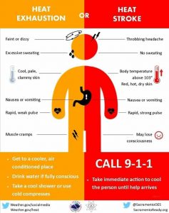
The National Weather Service urges people in the advisory and warning area to drink plenty of fluids, stay in an air-conditioned room, stay out of the sun, and to check in on relatives and neighbors. “Take extra precautions if you work or spend time outside. When possible, reschedule strenuous activities to the early morning or evening”, the National Weather Service cautions. People in the oppressive heat and humidity area should know the signs and symptoms of heat exhaustion and heat stroke.
To reduce risk during outdoor work, the Occupational Safety and Health Administration (OSHA) recommends scheduling frequent rest breaks in shaded or air conditioned environments. Anyone overcome by heat should be moved to a cool and shaded location. Heat stroke is an emergency and people should dial 911 if they believe a heat illness is occurring.
Young children and pets should never be left unattended in vehicles under any circumstances. This is especially true during warm or hot weather when car interiors can reach lethal temperatures in a matter of minutes.

Fortunately, the worst of the heat will wrap up today, with somewhat cooler conditions arriving for the balance of the week. A mid level disturbance associated with the convection in Ohio early this morning is expected to reach eastern
Pennsylvania, New Jersey and the upper DelMarVa Peninsula this evening. As that disturbance pushes east, thunderstorms could blossom closer to the I-95 corridor this evening. While conditions aren’t perfect for severe storms to form, they are ideal for heavy downpours which could create isolated flash floods. When encountering such a downpour, drivers should remember: turn around, don’t drown; never drive through flood waters.
After the main shot of showers and thunderstorms pushes through the Mid Atlantic early tonight, there should be lingering clouds and showers late tonight along with some residual thunder.
The first of two cold fronts will be arrive in the Mid Atlantic on Friday. Cooler air will start to push down into the region behind the front but the front will start to wash out as it moves closer to the I-95 corridor. Just how far south it moves will determine where thunderstorms will fire-up. Areas along and south of the front will have a greater chance for thunderstorm development. The National Weather Service’s Storm Prediction Center believes the area south of I-78 could be susceptible to severe weather, although the risk is slight. Atmospheric instability should be sufficient for scattered showers and thunderstorms to develop with the greatest threat being mainly damaging winds. Plenty of moisture exists across the region with precipitable water values in excess of 2 inches keeping heavy rain and flash flooding as a threat.
The second, stronger cold front will start to drop down into the area later on Friday and should help to bring an end to the convection and bring down those cooler temperatures into the area then.