
The forecasters with the National Weather Service and their Storm Prediction Center are busy today with a widespread severe weather outbreak expected over a very large portion of the eastern United States. While this severe weather set-up has prompted them to issue Severe Thunderstorm Watches across a very large area, there is also an elevated threat of tornadic cells around eastern Pennsylvania, New Jersey, Delaware, and eastern Maryland.
Clusters of severe thunderstorms with strong, potentially damaging winds are possible today along an axis from eastern Kansas into Arkansas/Mississippi, then extending across the southeast states into the Carolinas and Mid Atlantic region.
According to the Storm Prediction Center, a variety of weather ingredients are coming together today to create the severe weather threat. A broad upper trough persists over the eastern U.S. with the main baroclinic zone extending from eastern New York and Pennsylvania southward into the Mid Atlantic region and western Carolinas. Pockets of strong heating and a very moist surface air mass will result in moderate atmospheric activity ahead of the front this afternoon, where scattered thunderstorms are forecast to develop. Cyclonic flow aloft around the upper trough will be sufficient to help organize storms into multicell clusters capable of damaging wind gusts and some hail. This activity will slowly move eastward through the early evening with a continued severe threat.
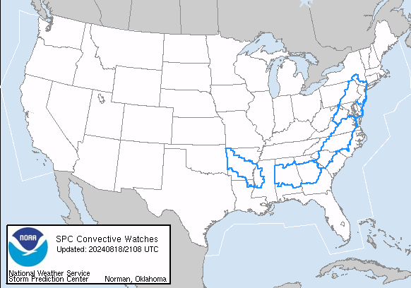
With the threat of severe weather, the Storm Prediction Center has issued Severe Thunderstorm Watches across portions of New York, New Jersey, Pennsylvania, Maryland, Delaware, Virginia, North and South Carolina, Georgia, Alabama, Mississippi, Louisiana, and Arkansas. Within this area, numerous Severe Thunderstorm Warnings are being issued; Tornado Warnings may also be issued as tornadic cells take shape.
In addition to the threat from damaging winds and tornadoes, some slow moving cells may also lead to torrential downpours. These downpours may also create serious flash flood problems, prompting the National Weather Service to also issue Flash Flood Warnings for many areas being impacted by these storms. The National Weather Service cautions, “Turn around, don’t drown; never drive through flood waters.”
You can view current warnings throughout the United States here: https://weatherboy.com/current-warnings/
