• Skip to primary navigation
  • Skip to main content
  • Skip to primary sidebar

Weatherboy

Weatherboy Weather News, Maps, RADAR, Satellite, and Forecasts.

  • Local
  • Earth Science News
  • RADAR
  • Current Warnings
  • Satellite
  • Current Maps
  • Forecast Maps
  • Video

Moderate Risk of Excessive Rainfall and Flooding on Sunday in the Northeast

by Weatherboy Team Meteorologist - July 15, 2023

Excessive rainfall is possible throughout the colored zones in the northeast, but the red area has the highest threat of excessive rainfall which could lead to flooding. Image: NWS WPC


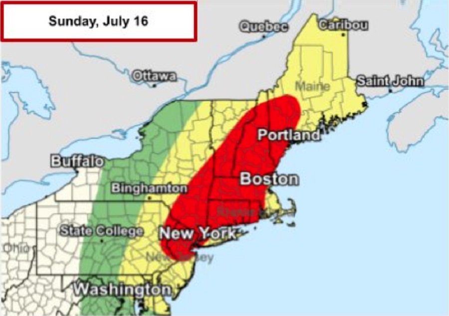
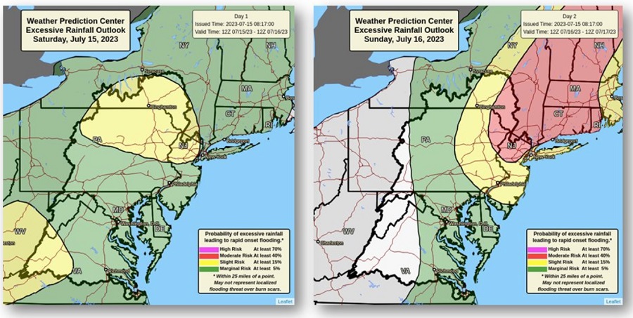
Heavy rain and strong thunderstorms are likely across the northeast this weekend, with a significant threat of flooding rains arriving tomorrow especially for a zone that stretches from central New Jersey and eastern Pennsylvania north and east across New England into southwestern Maine. According to the National Weather Service’s Weather Prediction Center, over 31 million people are under a Moderate Risk of Excessive Rainfall tomorrow as another round of heavy rain is expected to produce significant flash flood concerns along the I-95 corridor.

Anomalously moist air pushing north ahead of a frontal boundary will lead to another round of heavy rain across the northeast tomorrow. An additional 2-4″ of rain, with some localized 5″+ possible, falling on top of very wet soils and swollen streams and rivers will lead to further flooding concerns.  Numerous flash floods are likely, especially in portions of New Jersey, Pennsylvania, New York, Connecticut, Massachussetts, New Hampshire, Vermont, and Maine.

The National Weather Service wants people in this area to remember 3 things to be prepared for the storm: stay weather aware, have multiple ways to receive flood warning notifications, and remember to never drive or walk into a flooded road.


While heavy showers and storms are possible today, the greatest threat arrives on Sunday. Image: NWS WPC

In addition to heavy rain, there is the possibility of wind damage, large hail, and isolated tornadoes in the northeast tomorrow too. According to the National Weather Service’s Storm Prediction Center, storms are likely to be ongoing from Virginia north into New York and southern New England, with bands of convection possible oriented south-southwest to north-northeast.  Given the long duration of storms throughout the period, chances for locally strong gusts or even a brief or weak
tornadoes have been extended eastward into southern New England where high dewpoints along with atmospheric instability may  support transient areas of rotation within the more prolonged bands or zones of convection.

Primary Sidebar

Sponsored Ad

Search

Latest News

  • Harvard Scientist Tracking 3I/Atlas Believes New Photos May Show Alien Spacecraft Engines
  • Geomagnetic Storm Watch for MODERATE Storm November 8
  • Alien Spaceship or Unusual Comet? More Demand Answers on Color/Speed/Shape Shifting Object in Space
  • 31+ Quakes Rattle Texas Today: Likely Fracking Related
  • Damaging Wind Gusts and Snow Squalls Possible in Northeast on Wednesday
  • 300+ Earthquakes Rock Caribbean, Still No U.S. East Coast Tsunami Threat
  • Atlantic Hurricane Basin Quiets with 4 Weeks of Season To Go
  • Quake Rattles Heart of New Madrid Seismic Zone in Missouri
About | Careers | Contact | Contests
Terms | Privacy | Ad Choices
Weatherboy is a (R) Registered Trademark of isarithm LLC, All Rights Reserved.
All content herein is Copyright by Isarithm LLC 1997-2022

Insert/edit link

Enter the destination URL

Or link to existing content

    No search term specified. Showing recent items. Search or use up and down arrow keys to select an item.