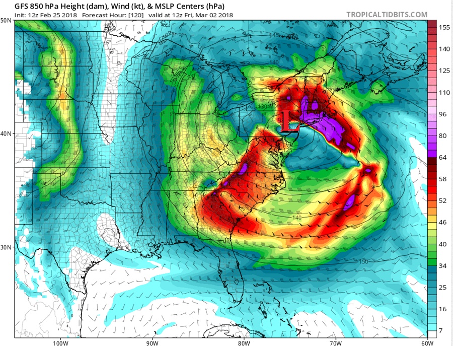
A monstrously large storm is forecast to impact much of the Eastern United States next weekend, bringing an abundance of weather hazards to a very large area. Heavy precipitation, strong winds, coastal erosion and flooding, and the potential for severe weather will all be possible in this storm. Geographically impressive, the area of low pressure is forecast to be very large, bringing rough weather from Florida to Maine and Illinois to North Carolina.

The storm system will take shape over the middle of the week and head to the coast quickly by the end of it. The system will first produce another round of flooding rains for portions of the Mississippi River Valley early Thursday. By Thursday night, the heavy rain will race to the Mid Atlantic while wind-whipped snows blast the norther Great Lakes region. On Friday, the storm center will be on or near New Jersey as low pressure intensifies. Winds up much of the East Coast will pick up as precipitation becomes more concentrated and heavy over the Mid Atlantic and New England.
The storm system will slowly move over the western Atlantic Ocean on Saturday, but due to its massive size, will continue to produce precipitation, rough surf, and wind during the first half of the weekend.
With mild air expected to be entrenched into this system, most of the precipitation that falls from it will be in the form of rain. Some of that rain will be heavy at times, saturating a region that’s seeing bad flooding this weekend. Severe weather is possible in the southern side of the storm while heavy snow is possible on the northern part of this broad storm system. It is still too soon to say with certainty where the snow/rain line will set up in the northeastern US; at this time, it is more likely than not that it will be well north and west of the heavily populated I-95 corridor.
While precipitation types and amounts will be determined in time, one thing is certain: very rough seas will be formed by such a storm. Wave heights near or over 50 feet will be possible on off-shore waters. On-shore, a combination of lunar high tides with rough wave action will lead to coastal erosion and flooding. Residents and visitors in coastal flood prone areas should take action now to prepare for what could be a significant flooding event at the end of this week into the weekend.