• Skip to primary navigation
  • Skip to main content
  • Skip to primary sidebar

Weatherboy

Weatherboy Weather News, Maps, RADAR, Satellite, and Forecasts.

  • Local
  • Earth Science News
  • RADAR
  • Current Warnings
  • Satellite
  • Current Maps
  • Forecast Maps
  • Video

More Flash Floods Destroy Another National Park

by Weatherboy Team Meteorologist - August 1, 2022

Many roads throughout Mojave National Preserve have been washed-out or destroyed in recent flash floods to impact the region. Image: Mojave National Preserve / NPS

More flash floods have destroyed the roads of yet another National Park; this time, heavy rains washed away many roads within Mojave National Preserve in southern California, which runs along the California/Nevada border outside of Las Vegas.

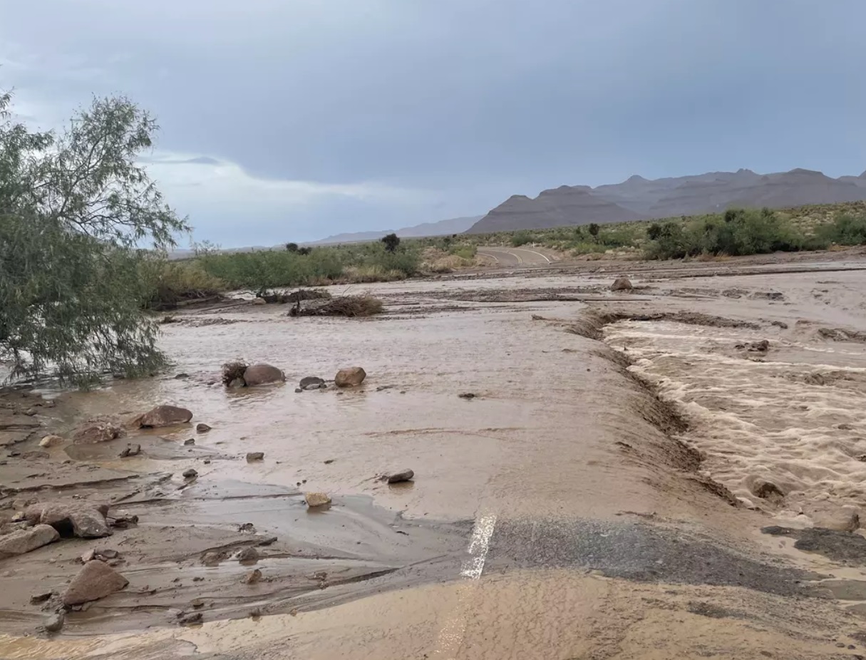
“Due to flash flooding and road washout ,some major paved park roads are currently closed. Crews are assessing the situation and working to reopen when safe for the public,” said park authorities in a statement released yesterday.

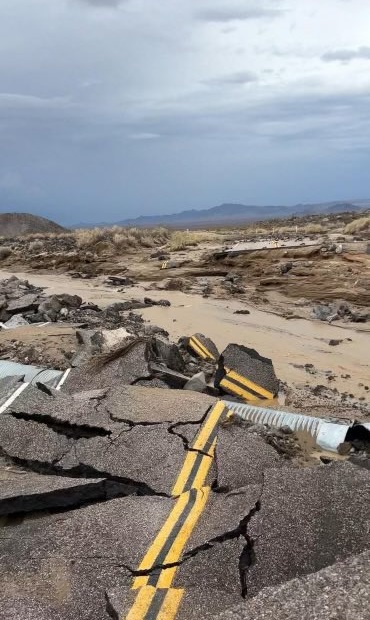
Eight of 9 roads through the park are closed due to assorted damage. Even the ninth that is open, Zzyzx Road, has damage with “some wash out” and “short rough section of gravel” left.  The Zzyzx Road sign has become a bit of a tourist attraction of itself along I-15, the major highway that connects Las Vegas to the Los Angeles metro area.


The paved roads in the preserve require constant maintenance, especially when summer monsoons can lead to washouts like this on Lower Black Canyon Road. Image: NPS / Sierra Willoughby


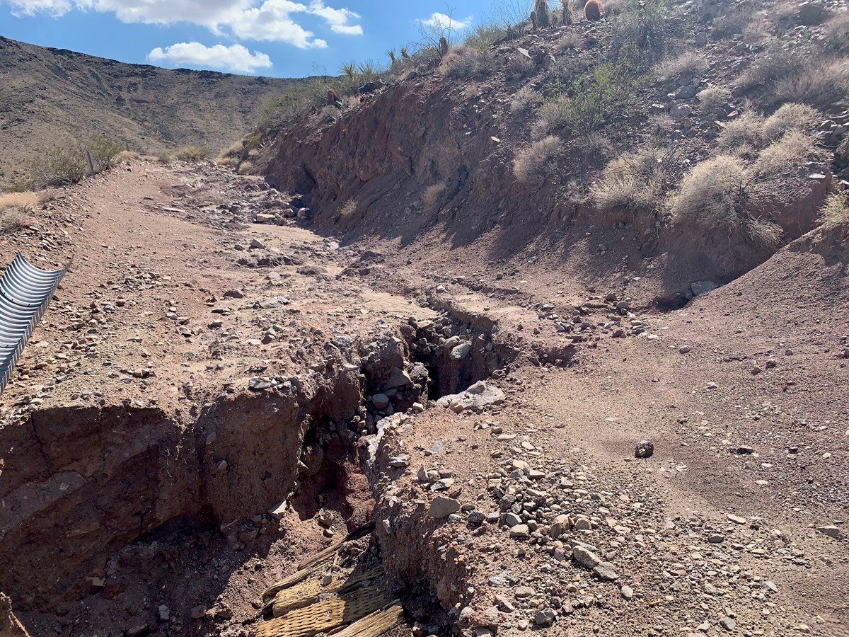
Other roads that are too damaged to open include Black Canyon Road, which has areas of soft sand and washouts, Essex Road which is missing shoulder areas and has debris covering the road, Kelbaker Road which is completely washed out, and Cima Road which has debris on the roads. Ivanpah, Cedar Canyon, and Morningstar Mine Roads are also closed.


As of July 29, 2022, Mojave Road is washed out and impassible in the Paiute Range. Washout is located at GPS coordinates 35.0905677, -115.0028316. Image: NPS / Mojave National Preserve, Courtesy of Jeff with Desert Overlanders


Mojave isn’t the only National Park Service operated park to be badly damaged by flash floods. In June, flash floods destroyed many roads and buildings in Yellowstone National Park, forcing a long-term closure for many parts of that park too.

Primary Sidebar

Sponsored Ad

Search

Latest News

  • Another Stronger Quake Rattles Ohio, Second in Two Days
  • Tropical Storm Philippe Forms in the Atlantic
  • Flood, Tornado Threats Persist After Landfall of Ophelia
  • Storm Surge Likely from South Carolina to New Jersey as Ophelia Makes Landfall
  • Tropical Storm Ophelia Continues to Gain Strength
  • Earthquake Rattles Northeast Ohio
  • Mid Atlantic Braces for Impacts from Ophelia: Tropical Storm Force Winds, Flooding Rains, Tornadoes, Life Threatening Storm Surge
  • North Carolina to New Jersey on Alert as Coastal Storm Takes Shape
About | Careers | Contact | Contests
Terms | Privacy | Ad Choices
Weatherboy is a (R) Registered Trademark of isarithm LLC, All Rights Reserved.
All content herein is Copyright by Isarithm LLC 1997-2022