• Skip to primary navigation
  • Skip to main content
  • Skip to primary sidebar

Weatherboy

Weatherboy Weather News, Maps, RADAR, Satellite, and Forecasts.

  • Local
  • Earth Science News
  • RADAR
  • Current Warnings
  • Satellite
  • Current Maps
  • Forecast Maps
  • Video

More Heavy Snow, Freezing Cold Expected in Northeast

by Weatherboy Team Meteorologist - April 19, 2021

While it is still too soon to know whether this computer simulation will verify, the American GFS forecast model is suggesting that 6-12"+ of snow could fall in portions of the northeast from this week's storm. Image: tropicaltidbits.com
While it is still too soon to know whether this computer simulation will verify, the American GFS forecast model is suggesting that 6-12″+ of snow could fall in portions of the northeast from this week’s storm. Image: tropicaltidbits.com


While the calendar is getting deeper into April with less than 2 weeks until the start of May, Old Man Winter doesn’t appear eager to leave: more heavy snow and freezing cold temperatures are expected in the northeast this week.

Tuesday will be the “quiet before the storm.” High pressure will temporarily provide the northeast with dry conditions, with clouds increasing from west to east late in the day.

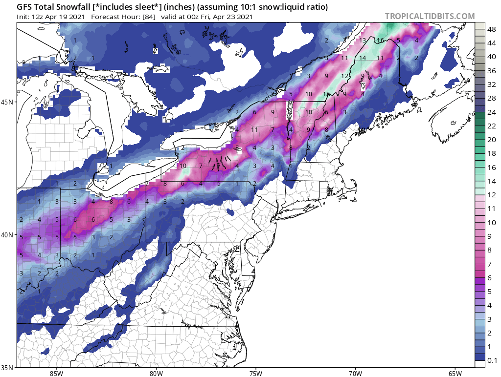
A strong frontal boundary will bring a variety of weather to the northeast. Soaking rain and possible thunderstorms are expected on Wednesday, with a  changeover to snow expected across the higher elevations and northernmost New England before ending early Thursday. Similar to last week’s April snowstorm, this next storm system could dump an area of 6″ or more snow.


While the snow will be restricted to northern New England and higher terrain in the northeast, much colder air won’t be as restrained in the wake of this storm. Temperatures will become unseasonably cold Thursday and Friday, with widespread freeze and frost conditions expected once again south into the Mid Atlantic.

Before it feels wintry, though, it will feel like spring on Wednesday though with that frontal passage: strong, potentially damaging wind gusts and severe thunderstorms with hail are also possible as the front initially crosses the region. While widespread river flooding is not expected at this time, there could be some localized stream or urban flooding in heavier rain showers.


Primary Sidebar

Sponsored Ad

Search

Latest News

  • Tornado Confirmed in New Jersey
  • National Hurricane Center Initiates Daily Reports Today
  • Severe Weather Likely Across Broad Area on Friday
  • Heat Blast Expected from Texas to Florida and from Minnesota to Arkansas
  • Mid Atlantic to Become Extra Moist
  • Southeast Soaker Likely Next 72 Hours
  • Igloo Cooler Recalled Due to Amputation / Crushing Threat
  • Longtime TV Meteorologist Fired
About | Careers | Contact | Contests
Terms | Privacy | Ad Choices
Weatherboy is a (R) Registered Trademark of isarithm LLC, All Rights Reserved.
All content herein is Copyright by Isarithm LLC 1997-2022