While severe weather continues to break out over portions of the Midwest and Mississippi River Valley tonight, the National Weather Service’s Storm Prediction Center (SPC) is warning that more severe weather is likely tomorrow too from this storm system as it moves east into the eastern U.S.
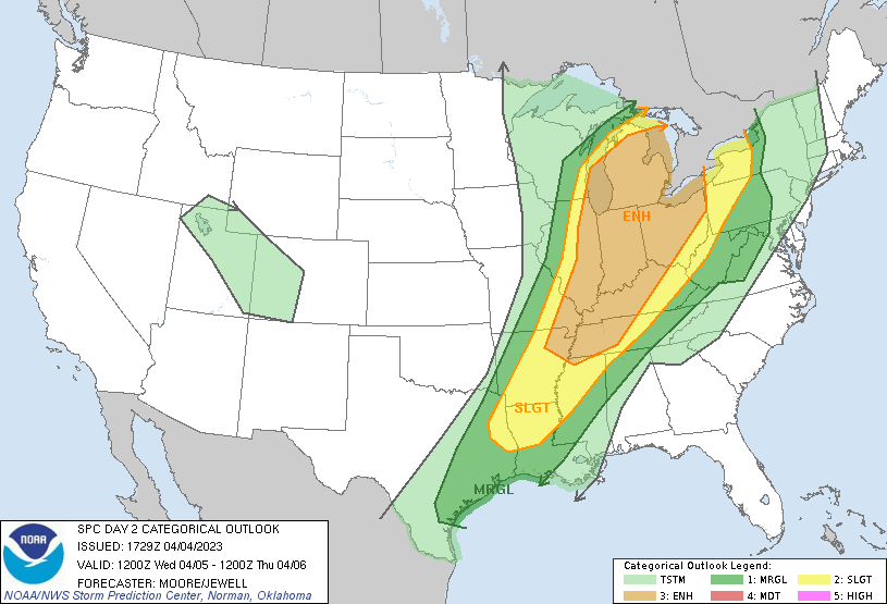
In the latest Convective Outlook for Wednesday, the SPC has highlighted an area which includes Michigan, Ohio, Indiana, Kentucky, Tennessee, and portions of Illinois, Missouri, and Arkansas in an area where there is an enhanced threat of severe weather. Within this area, there is an elevated threat of tornadic thunderstorms over much of Michigan, northern Ohio, the northern half of Indiana, and eastern Illinois.
Scattered severe storms posing a risk for strong tornadoes and large hail are expected in a corridor across eastern Illinois through Lower Michigan Wednesday, with organizing clusters or lines of storms accompanied by potentially damaging wind gusts, and a few tornadoes across the Ohio Valley vicinity.
It is likely Severe Thunderstorm Watches and/or Tornado Watches will be issued for these areas ahead of storm development. When severe storms and tornadoes are impacting or about to impact specific communities, Severe Thunderstorm Warnings or Tornado Warnings will be issued.
If a Tornado Warning is issued for your county, follow the instructions of state and local officials. Go to a safe shelter immediately, such as a safe room, basement, storm cellar, or small interior room on the lowest level of a sturdy building. Stay away from windows, doors, and outside walls. Do not open windows. If you’re on the road, do not go under an overpass or bridge; you are safer in a low, flat location. Watch out for flying debris that can cause injury or death. Use your arms to protect your head and neck. Do not try to outrun a tornado if you’re in a vehicle. If you are in a car or outdoors and cannot get to a building, cover your head and neck with your arms and cover your body with a coat or blanket, if possible. You may only have seconds or minutes to react in the time between a Tornado Warning is issued and when the tornado impacts your area.
