While the calendar says the end of December is here, there doesn’t appear to be an end in sight for severe weather outbreaks: more severe weather is likely today over the southeast. The National Weather Service has already started to issue Tornado Watches for the region.
Right now, the continental U.S. remains under the influence of prolonged troughing in the Intermountain West and ridging in the Southeast. While the west continues to see very moisture-rich snow and rain storms and the upper Midwest sees frigid cold, the anchored ridge atop the southeastern U.S. shows no sign in relinquishing its spring-like regime in the South and East-Central U.S.. Numerous record warm lows and highs are anticipated from the Southeast coast to the Rio Grande of South Texas today. More of the same is expected in the Southeast on Thursday with highs in the 70s and lows that are 20 to 40 degrees above normal.

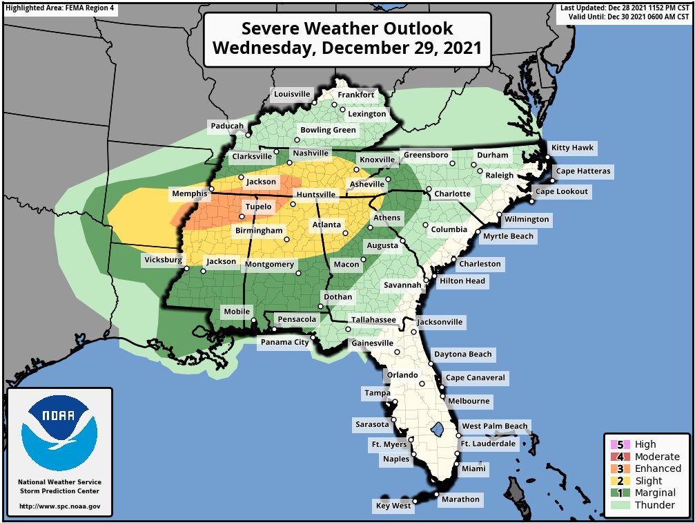
Unfortunately, this scenario of warm, moist air rising north while cold air enters the region from the north all while an energetic storm system exits the Rockies is a recipe for severe weather. In terms of precipitation, moist southerly flow and increasing instability levels will lead to an increasingly favorable environment for severe weather. The National Weather Service’s Storm Prediction Center (SPC) has issued an Enhanced Risk (threat level 3/5) for parts of the Lower Mississippi Valley, while a Slight Risk (threat level 2/5) stretches from southern Arkansas to the southern Appalachians.
According to the National Weather Service, highly anomalous moisture content also supports the threat for Excessive Rainfall, thus leading to the issuance of a Slight Risk for the Tennessee Valley today due to a heightened chance for localized flash flooding. The National Weather Service warns people in this region to watch out and avoid flood conditions; they advise, “turn around, don’t drown; never drive through flood waters.”
The first of what is likely to be many severe weather watches has been issued. A Tornado Watch is now in effect across northeastern Louisiana, southeastern Arkansas, southwestern Tennessee, and northern Mississippi. Additional Tornado Watches, Severe Thunderstorm Watches, and Tornado and Severe Thunderstorm Warnings are likely throughout the day.
