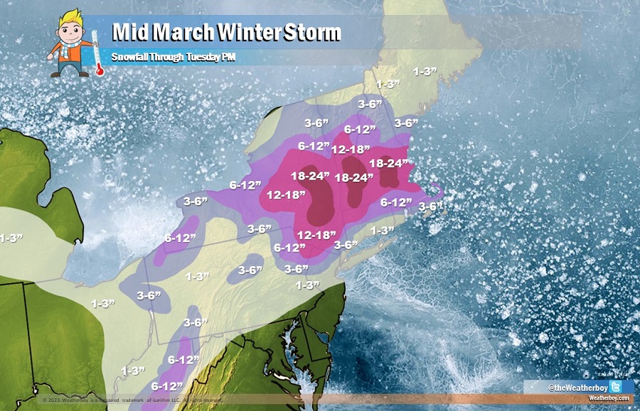
Another winter storm will impact the Northeast in the coming days, with more than a foot of snow expected for an area stretching from northern New Jersey into Massachusetts. Some areas of the higher elevations of central New England could even see up to two feet of snow before the storm winds down late Tuesday night. The storm will impact the northeast the most Monday night through Tuesday night, with heavy wet snow, strong winds and potential power outages.
A clipper system currently moving east through the lower Great Lakes will spread light to moderate snowfall across the Great Lakes through tonight before reaching interior New England on Monday. Farther south, a wavy front is forecast to bring some severe thunderstorms across the Southeast through tonight. This wave is forecast to interact with the clipper system moving across the Great Lakes and intensify rapidly into a potent nor’easter off the New England coast on Tuesday, bringing heavy wet snow inland and high winds with rain/snow near the coast. Heavy snow rates of up to 2 inches per hour possible and strong winds will likely produce dangerous to near impossible travel. The heavy-wet nature of the snow could result in scattered to widespread power outages and tree damage.
In addition, the system may produce localized higher snowfall amounts for portions of the Catskills in New York, Berkshires in western Massachusetts, and southern Green Mountains in Vermont should a smaller scale low pressure system form near the southern New England coast along an inverted trough. In these localized areas, up to 2 feet of snow are possible.
Widespread minor coastal flooding may be possible Monday Night through Wednesday as the low pressure deepens off the coast of New England with high winds most likely near Cape Cod later on Tuesday.
While this system will produce significant snow for Boston, the same is not expected south along the I-95 corridor from New York City to Philadelphia. Conditions will be mild enough to produce mainly rain here. However, as colder air wraps around behind the system, the rain could end as snow and a light accumulation is possible for New York City and nearby suburbs. Still, most of the heavier snow will fall well north of the New York City area.
