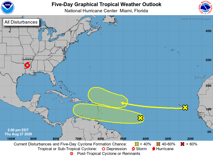
While the National Hurricane Center continues to issue advisories on Tropical Storm Laura, currently located inland over northwestern Louisiana, they are monitoring two other areas of concern in the Atlantic hurricane basin that could develop into new tropical cyclones over time.
The first system is a westward-moving tropical wave located over the far eastern tropical Atlantic near the Cabo Verde Islands. At this hour, it continues to produce disorganized shower activity. According to the National Hurricane Center, although environmental conditions are not expected to be conducive for development during the next couple of days, they are forecast to gradually become more favorable over the weekend and into early next week when the wave moves into the central and then western tropical Atlantic. For now, there’s only a 20% chance of tropical cyclone development here over the next 5 days.
Another area of concern has slightly better odds of developing into a tropical cyclone over the next 5 days. Shower and thunderstorm activity has increased today in association with a tropical wave over the central tropical Atlantic. According to the National Hurricane Center, gradual development of this system is possible over the next several days as it moves westward at 15 to 20 mph. The odds of it developing into a tropical cyclone for now is 30% but those odds can increase over time.
When the next system does develop and becomes a tropical storm, it will be given the name Nana.
Laura was the first major hurricane of the 2020 Atlantic Season and experts predict many more. In an update earlier this month, NOAA said there’d be a total of 3-6 major hurricanes in the Atlantic basin; scientists at Colorado State University also released an update, saying there’d be a total of 5. Even a non-major hurricane could be catastrophic and both outlooks are calling for many more non-major storms this season. A major hurricane is one that has maximum sustained winds greater than 110 mph. Hurricane Laura had maximum sustained winds of 150 mph at landfall.
With so many storms and advisories out already, and the ongoing impacts of the COVID-19 global pandemic, experts are concerned that disaster fatigue may be setting in and may not be as prepared as they should for what is likely to be a very active period in the tropics in the coming months.
“We have to be open and honest about the challenges that people face, ” Mike Brennan, Ph.D., told us; he serves as Senior Hurricane Specialist at the National Hurricane Center. “And we need to remind people that the situation of where they lived in June may be different from what it’s going to be related to COVID when the next storm arrives in September. Pay attention to that local situation and your local emergency managers –those are the people that will tell you what you need to do to be prepared for the hurricane in the COVID environment where you live.”
“Repetitiveness of storms becomes an issue, ” says Dr. Uccellini, Director of the National Weather Service. We asked Dr. Uccellini for his thoughts on disaster fatigue and what they’re doing to keep people informed and safe. “We need to be persistent in our messaging. It’s really important that communities don’t let their guard down.” Dr. Uccellini also said this is a “whole community effort, not just the National Weather Service, but one that involves the whole weather enterprise.” Dr. Uccellini says players across the weather enterprise need to rally around a consistent message to “ensure communities don’t let their guards down.” Even with multiple disasters impacting the United States, Dr. Uccellini said it’s important that everyone “be ready and responsive” for what lies ahead.
To be prepared, the weather enterprise is encouraging that everyone to have a Hurricane Action Plan, even if they were already impacted by a tropical cyclone this year. Due to COVID-19, people should also factor the pandemic in their planning and think about extra supplies they may need or restrictions they may encounter when executing a plan or evacuating an area from a hurricane threat. A good Hurricane Action Plan details what you’d do before a hurricane or tropical storm arrives, what you’d do during impact, and what you would do in a storm’s wake.
