While no tropical cyclones are impacting the United States this weekend, the National Hurricane Center (NHC) in Miami, Florida is busy tracking two systems in the Atlantic Hurricane Basin. The first is Major Hurricane Larry, a large and powerful hurricane well south and east of Bermuda. The other is an area of disturbed weather over the Gulf of Mexico that could develop into a tropical cyclone in time. Even if the Gulf system doesn’t develop, it may bring heavy rain to areas that don’t need any.
As of the latest advisory from the National Hurricane Center, Major Hurricane Larry had maximum sustained winds of 125 mph as it moved to the northwest at 13 mph. Larry’s minimum central pressure is 955 mb or 28.20″. Larry is located roughly 830 miles east-northeast of the northern Leeward Islands and about 1,195 miles southeast of Bermuda. There are no tropical storm or hurricane watches or warnings up at this time for Larry.
Large swells generated by Larry are expected to reach the Lesser Antilles today and will spread to portions of the Greater Antilles, the Bahamas, and Bermuda tomorrow and Tuesday. The National Hurricane Center also says significant swells will reach the U.S. east coast by mid-week, causing life-threatening surf and rip currents.
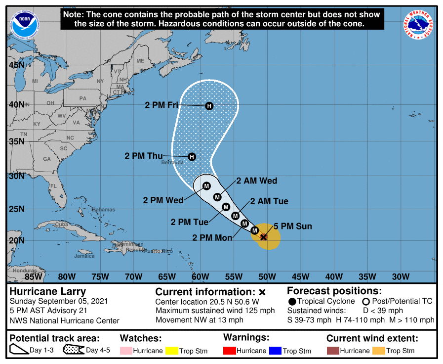
Larry is forecast to approach Bermuda during the next several days, likely as a major hurricane, bringing a risk of strong winds, heavy rain, and coastal flooding to the island by the middle of this week. The NHC says, “While it is too soon to determine the magnitude of these hazards and the potential impacts on Bermuda, interests there should closely monitor the forecast updates during the next several days.”
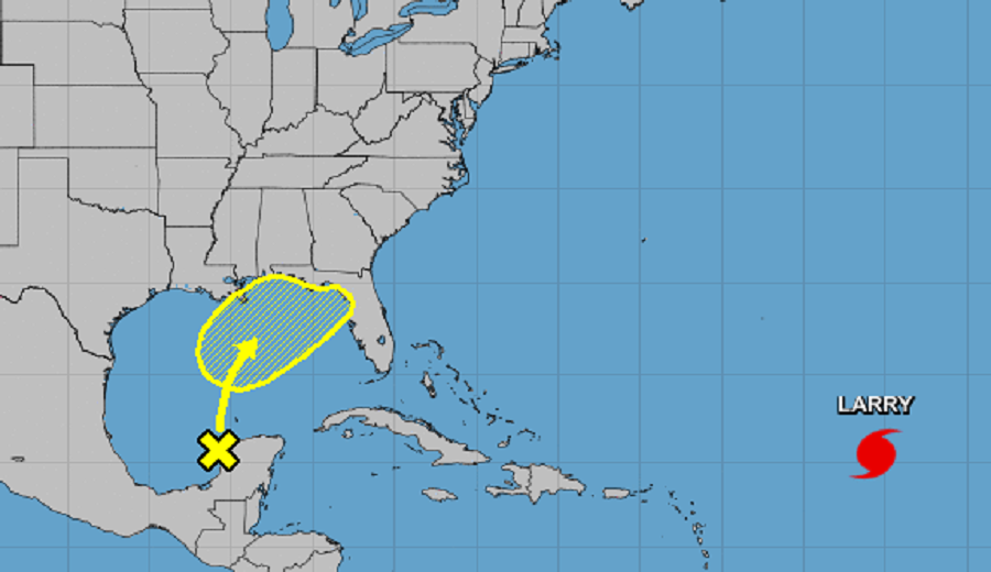
While Larry spins about in the Atlantic, the NHC is also paying attention to activity in the Gulf of Mexico. Disorganized showers and thunderstorms over the Yucatan Peninsula and surrounding waters are associated with a surface trough and an upper-level disturbance located over the eastern Bay of Campeche. According to the NHC, locally heavy rains are likely to continue through tonight over that area. The system is forecast to move slowly northward or northeastward over the central and then northeastern Gulf of Mexico over the next few days. Although upper-level winds are currently unfavorable for development to occur, the NHC says they are expected to become marginally conducive for tropical cyclone formation by late Tuesday.
Beyond Tuesday, the NHC says that the disturbance is expected to cross the southeastern United States beginning midweek, and some development will be possible once it emerges over the Atlantic waters by late this week.
Any moisture moving into the Gulf Coast or eastern United States could be problematic. With areas still recovering from the flooding from Hurricanes Henri and Ida, any additional heavy rain could create significant problems. People along the Gulf and East coast should continue to monitor the Gulf system and any updates that the National Hurricane Center or National Weather Service may issue about it.
