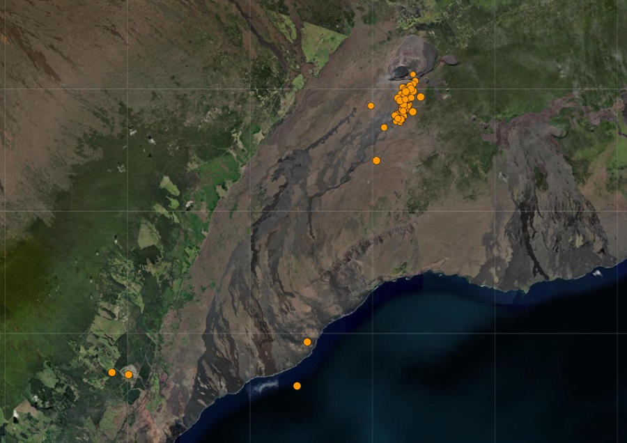
According to USGS, one of the nation’s most dangerous volcanoes is showing signs of life this weekend. USGS detected more than 80 earthquakes in the last 24 hours around the Kilauea Volcano on the Big Island of Hawaii. Hawaiian Volcano Observatory (HVO) released in a statement today, “Over the past day, seismicity picked up in the south caldera region, but has remained steady. Kilauea summit remains pressurized; in recent months unrest has escalated quickly, and an eruption could occur in the future with little warning. ” Kilauea is an active shield volcano located along the southeastern shore of Hawaii’s easternmost island; it last had an eruption in September.
HVO added, “Rates of seismicity in the south caldera area increased yesterday morning, but remained stable through the day. This morning, seismicity is somewhat lower, but a tiltmeter near Sand Hill indicates ongoing inflationary deformation Periods of increased seismicity can be expected to continue during re-pressurization of the summit magma reservoir, which has been ongoing since the end of the September 2023 eruption. Kilauea’s summit region remains at a high level of inflation. Together with the increase in seismicity yesterday morning, a tiltmeter near Sand Hill indicated an increase in inflationary tilt. The tilt rate has remained steady over the past 24 hours (neither increasing nor decreasing). A tiltmeter near Uēkahuna bluff also responded to yesterday’s events, but to a lesser degree, as this instrument is not as sensitive to south caldera changes.”
HVO scientists have been observing tiltmeter data to look for clues when the next eruption could occur. Tilt measurements have been used to monitor volcanoes in the United States since the founding of the Hawaiian Volcano Observatory in 1912. When magma accumulates beneath the ground, causing the surface above to inflate, the slope of adjacent areas will usually tilt away from the center of uplift. Conversely, if the ground deflates as a consequence of magma draining from a subsurface reservoir, the slope of adjacent areas will tilt toward the center of subsidence.
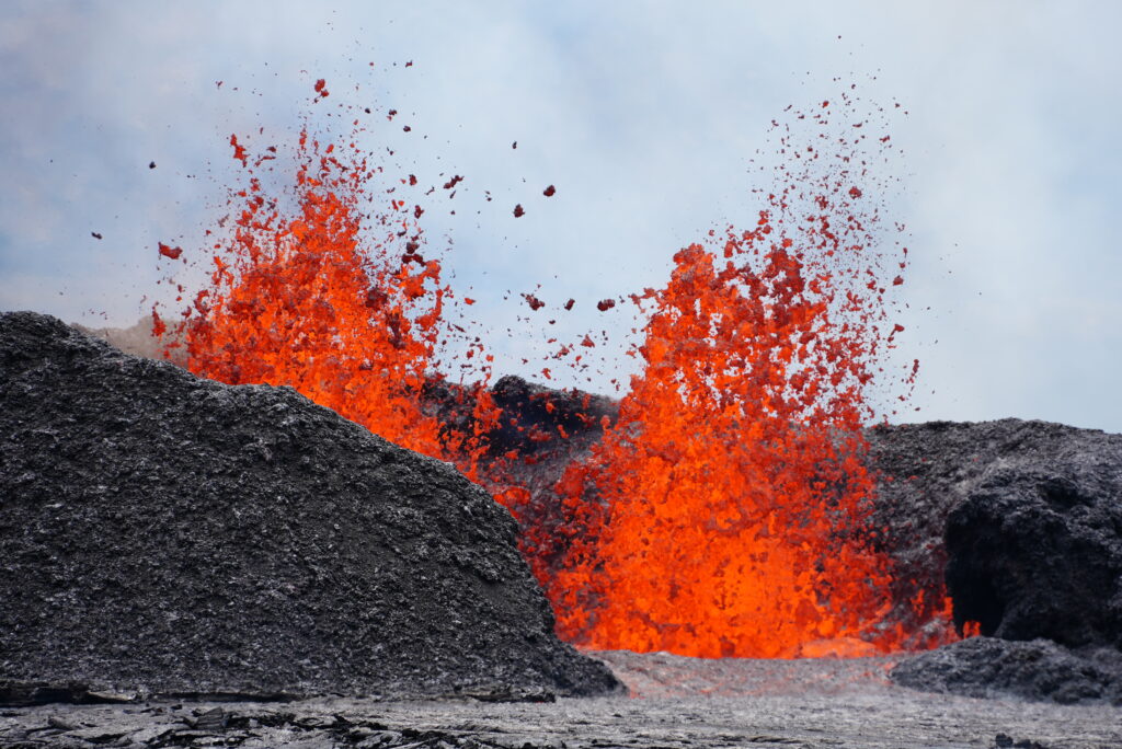
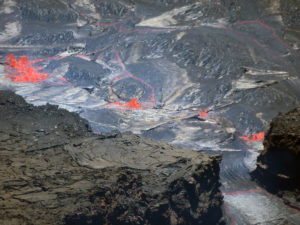
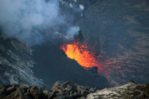
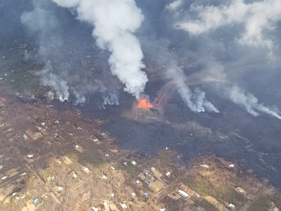
This surge of activity at the volcano is occurring just months after another eruption at the summit ended. Back on September 16, HVO declared the most recent eruption to be over. With the eruption over, the amount of volcanic gas spewing into the air was also significantly reduced, helping clear the air of many communities on the island which had harmful levels of volcanic-induced air pollution. Kilauea exploded to life on September 10 after an intense swarm of earthquakes near the summit. The lava put on quite the show for visitors who were able to safely observe the eruption inside the volcano caldera from above it at Hawaii Volcanoes National Park. The lava from that eruption never left the summit caldera. Earthquake activity from that volcanic event was around the summit caldera, while this most recent swarm is beyond it.
USGS considered Kilauea to be one of the most dangerous volcanoes in the United States. As part of its program of keeping officials and the public apprised of volcanic threats, the USGS periodically reassesses the threat level of U.S. volcanoes and updates volcanic threat assessment documentation. In 2005, the USGS published its first national volcanic threat assessment in support of establishing a National Volcano Early Warning System. The assessment helps to prioritize U.S. volcanoes for research, monitoring and mitigation efforts based on objective measures of volcano hazards and exposure of people and infrastructure to those hazards. The assessment was updated in 2018.
In 2018, Kilauea was ranked by USGS as the U.S. volcano with the highest threat score. Kilauea is the most active U.S. volcano; it erupts fluid lava flows but is also capable of explosive eruptions. The eruptive activity in 2018 and the destruction of residential subdivisions on its flanks are clear examples of why Kilauea is a very high threat volcano. In 2018, more than 700 structures were destroyed when swift-flowing lava erupted from fissures in Kilauea Volcano’s lower East Rift Zone. Lava covered 35.5 square kilometers (13.7 square miles), which included homes, farms, wild spaces, roads, highways and critical infrastructure. Ultimately, Kilauea is ranked as the U.S. volcano with the highest threat score in the very high threat category.
While Kilauea has threatened the lower East Rift Zone just over 5 years ago, the latest activity is happening in the opposite direction near the West Rift Zone of the volcano. Much of this area is within unpopulated National Park Service land, although volcanic hazards from an eruption could spread far beyond it depending on where and how the next eruption unfolds.
Kilauea is not erupting at this time but scientists aren’t sure when it will. For now, scientists are putting the volcano at an “ADVISORY” alert level while the current aviation color code is “YELLOW.”
In the U.S., the USGS and volcano observatory units are responsible for issuing Aviation Codes and Volcanic Activity Alert Levels. Aviation Codes are green, yellow, orange, or red. When ground-based instrumentation is insufficient to establish that a volcano is at a typical background level of activity, it is simply “unassigned.” While green means typical activity associated with a non-eruptive state, yellow means a volcano is exhibiting signs of elevated unrest above known background levels. When a volcano exhibits heightened or escalating unrest with the increased potential of eruption, it jumps to orange. Finally, when an eruption is imminent with significant emission of volcanic ash expected in the atmosphere or an eruption is underway with significant emission of volcanic ash into the atmosphere, the code becomes red. Volcanic Activity Alert levels are normal, advisory, watch, or warning. As with aviation codes, if data is insufficient, it is simply labeled as “unassigned.” When the volcano is at typical background activity in a non-eruptive state, it is considered normal. If the volcano exhibits signs of elevated unrest above background level, an advisory is issued. If a volcano exhibits heightened or escalating unrest, a watch is issued while a warning is issued when a hazardous eruption is imminent.
Within the United States, the USGS tracks 169 potentially active volcanoes, most of which are in Alaska. Alaska is home to many volcanoes, though; there are more than 130 volcanoes and volcanic fields which have been active within the geologically young last 2 million years. 50 have been active since the mid 1700s and AVO studies those too. Another place famous for its volcanoes is Hawaii; on the Big Island of Hawaii, Kilauea, Mauna Loa, and Hualalai are considered active and potential threats. Volcanoes in Hawaii are monitored by the Hawaii Volcano Observatory (HVO). The U.S. is only home to a fraction of the world’s volcanoes: according to USGS, there are normally around 2 dozen erupting volcanoes around the world at any given time. The USGS says there are about 1,500 potentially active volcanoes worldwide, with about 500 of the 1,500 erupting in modern historical times.
