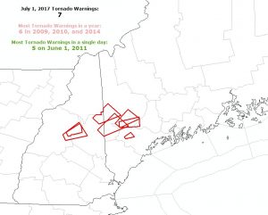
Just a week after the remnants of Tropical Storm Cindy brought severe thunderstorms with damaging winds and tornadoes to places like New Jersey, the northeast was under the gun again as another potent frontal system brought a round of severe weather. Early on Saturday, the National Weather Service’s Storm Prediction Center issued a Convective Outlook which puts a large area near and north and west of the I-95 corridor from Virginia to Maine under an increased threat of severe thunderstorms. As predicted, those thunderstorms blossomed in the afternoon heating, with some taking on rather violent characteristics.
At the National Weather Service office in Gray, Maine, meteorologists there were busy tracking cells within a record breaking number of Tornado Warnings. Previously, the most tornado warnings ever issued there in a single day was 5; the most tornado warnings ever issued in a full year was 6; yesterday’s 7 warnings broke both records. Meteorologists plan to be out in the field today to determine if any of the tornado warned cells resulted in actual tornado touch-downs. Even if tornadoes aren’t confirmed, the damage is. The Sebago Lake area was especially hard hit, with damage to boats. In West Bridgton in Cumberland, law enforcement reported that roads were impassable there from debris and that trees and homes were damaged by the fierce storms that blew through.
In addition to the tornadic cells in New England, severe weather struck as far south as New Jersey and Pennsylvania where Severe Thunderstorm Warnings were up. The National Weather Service defines a thunderstorm as “severe” when it contains a tornado and/or contains winds in excess of 58mph and/or contains large hail in excess of 1″ diameter. Heavy rain that cause flash floods and frequent, dangerous lightning are also possible in thunderstorms, severe or not.