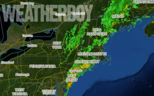
Residents in the Garden State got a rude awakening this morning as a line of potent storms triggered Tornado Warnings in New Jersey. What’s left of Tropical Storm Cindy and a potent cold front pushed east through the Mid Atlantic, bringing wind-whipped heavy rain to eastern Pennsylvania, New Jersey, and New York.
RADAR indicated several cells in New Jersey with some rotation, triggering tornado warnings to be issued. Even without the rotation, straight winds in excess of 40mph blew through, waking people up early on a Saturday if cell phones and NOAA Weather Radios didn’t.
The National Weather Service office in Mount Holly, NJ is collecting damage reports now; for now, they report numerous trees down in Gloucester City in Camden County, including one that fell onto a house.
While the morning is starting off stormy for many in the Mid Atlantic, the day won’t end that way. Fair high pressure is rapidly filling in behind this weather system and most will see dry, partly to mostly sunny skies by late morning to early afternoon. More pleasant weather is expected on Sunday: relatively low humidity, abundant sunshine, and seasonably warm temperatures.