After a successful launch in October, the new Sentinel-5P satellite is capturing incredible data from the recent California fires. The Sentinel 5-Precursor, known as Sentinel 5P for short, is part of the European Commission’s Copernicus program. The environmental monitoring program has a fleet of Sentinel satellites at its disposal, each tasked to monitor and image different aspects of the globe. Sentinel-5P is the first Copernicus mission dedicated to monitoring the Earth’s atmosphere. The satellite carries the state-of-the-art Tropomi instrument to map a multitude of trace gases such as nitrogen dioxide, ozone, formaldehyde, sulphur dioxide, methane, carbon monoxide and aerosols.
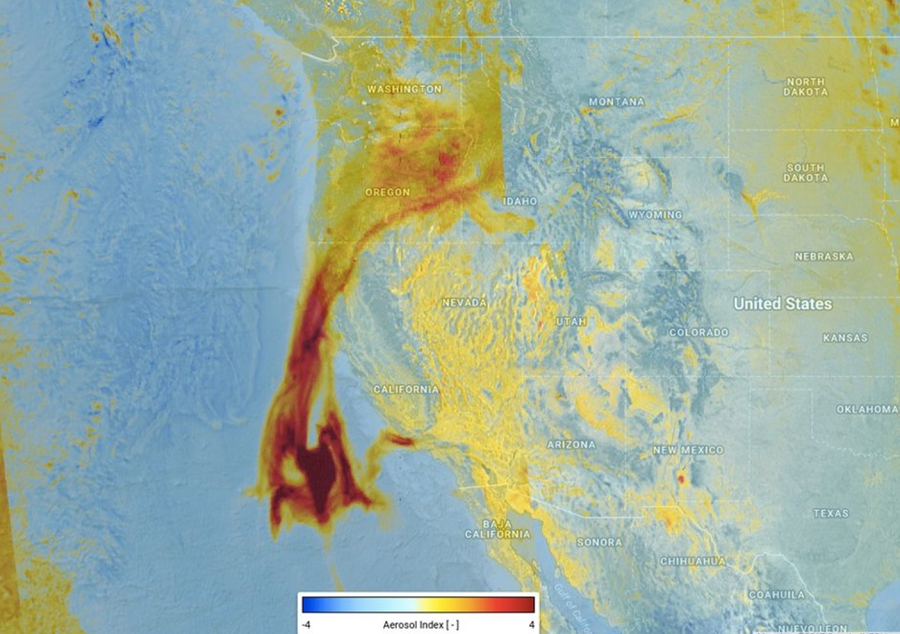
On December 12, this new satellite was able to capture the presence of elevated absorbing aerosols caused by the California fires. While the satellite is still in its commissioning phase, the Tropomi instrument isn’t fully calibrated. However, this preliminary image from Sentinel-5P shows the potential power the satellite has once it becomes completely operational. This view is one of many fields of data that’ll be coming from Europe’s Copernicus program and the Sentinel series of satellites.
With a swath width of of just over 1,600miles, Sentinel-5P will map the entire planet every day, transmitting valuable data through the Copernicus Atmosphere Monitoring Service for air quality forecasts. The Tropospheric Monitoring Instrument on board, also known as the Tropomi spectrometer, will map the global atmosphere every day with a resolution as high as 4.3 miles x 2.1 miles. At such a fine resolution, air pollution over cities can be detected.
Beyond air pollution, Sentinel-5P will also help monitor other harmful things in the sky. Volcanic ash monitoring will be possible, providing safety information of the aviation world. Data from Sentinel-5P can also warn of high levels of UV radiation which can cause skin damage and increase skin cancer risks. By exploring the data provided by the mission, scientists will also use the data to improve our knowledge of important processes in the atmosphere related to the climate and to the formation of holes in the ozone layer.
