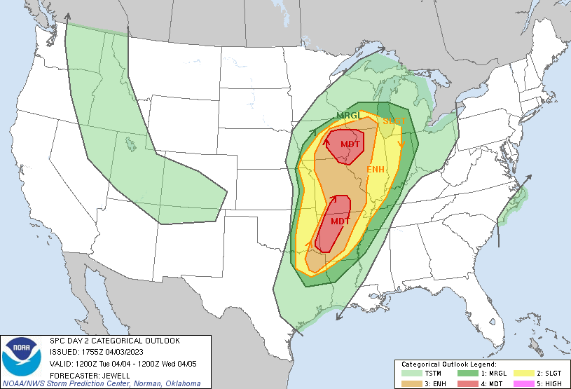
The National Weather Service’s Storm Prediction Center (SPC) is warning people about a new severe weather threat that’ll be arriving yet again in portions of Iowa, Illinois, Missouri, and Arkansas including areas hit hard by recent waves of severe weather last week. An area of more than 56,000 square miles with a population of more than 3.1 million people is now considered an elevated “moderate” threat risk zone for Tuesday.
The SPC says that a large area of severe potential will exist from Tuesday afternoon into Wednesday morning, from eastern portions of the Plains into the Missouri and mid/upper Mississippi Valleys, where strong tornadoes and particularly damaging winds are expected. Unfortunately, both afternoon and overnight potential will exist across various regions, including the risk of dangerous nighttime tornadoes –similar to what happened just days ago in last week’s outbreak.
It is likely Severe Thunderstorm Watches and/or Tornado Watches will be issued for these areas ahead of storm development. When severe storms and tornadoes are impacting or about to impact specific communities, Severe Thunderstorm Warnings or Tornado Warnings will be issued.
If a Tornado Warning is issued for your county, follow the instructions of state and local officials. Go to a safe shelter immediately, such as a safe room, basement, storm cellar, or small interior room on the lowest level of a sturdy building. Stay away from windows, doors, and outside walls. Do not open windows. If you’re on the road, do not go under an overpass or bridge; you are safer in a low, flat location. Watch out for flying debris that can cause injury or death. Use your arms to protect your head and neck. Do not try to outrun a tornado if you’re in a vehicle. If you are in a car or outdoors and cannot get to a building, cover your head and neck with your arms and cover your body with a coat or blanket, if possible. You may only have seconds or minutes to react in the time between a Tornado Warning is issued and when the tornado impacts your area.
