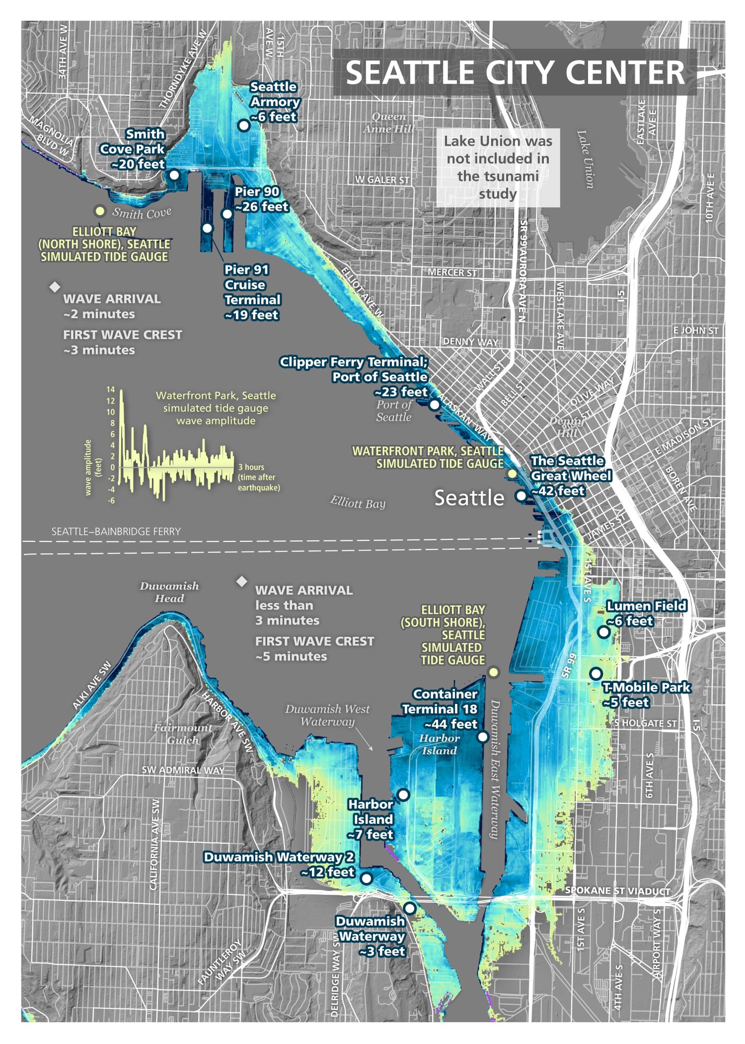
A new study shared today by the Washington State Department of Natural Resources modeled the impact of a magnitude 7.5 earthquake on the Seattle Fault; it shows giant tsunami waves from such an event reaching the greater Seattle area within 3 minutes.
Tsunamis are giant waves caused by earthquakes or volcanic eruptions under the sea. Out in the depths of the ocean, tsunami waves do not dramatically increase in height. But as the waves travel inland, they build up to higher and higher heights as the depth of the ocean decreases. The speed of tsunami waves depends on ocean depth rather than the distance from the source of the wave.
According to NOAA, the parent agency over both the National Weather Service and the Tsunami Warning Center, tsunami waves may travel as fast as jet planes over deep waters, only slowing down when reaching shallow waters. While tsunamis are often referred to as tidal waves, tides have little to do with these giant waves.
This study, prepared by geologists within the Washington Geological Survey division of the Department of Natural Resources, was conducted to help local and state emergency managers and planners develop and refine response and preparedness plans for a tsunami in the middle of Washington’s largest population center and economic hub.
The report finds tsunami waves would reach the shoreline in fewer than 3 minutes in many places on the eastern side of Bainbridge Island, Elliott Bay, and Alki Point. The report shows inundation from such a tsunami exceeding 20 feet along the shoreline of the greater Seattle area. While T-Mobile park could see 5′ of inundation, the Clipper Ferry Terminal could be under 23 feet of water while the Seattle Great Wheel would be under 42 feet of water. Container Terminal 18 on Harbor Island would also be under 44 feet of water.
“Most often, when we think of tsunamis, we think of our outer coast and communities along the Pacific Ocean. But there’s a long history of earthquakes on faults in the Puget Sound,” said Commissioner of Public Lands Hilary Franz. “While the history of earthquakes and tsunamis along the Seattle Fault is less frequent than the Cascadia subduction zone, the impacts could be massive. That’s why it’s critical these communities have the information they need to prepare and respond.”
The last known earthquake on the Seattle Fault occurred about 1,100 years ago. However, geologic evidence shows five additional earthquakes of an estimated magnitude 6.5 occurred within the Seattle Fault zone during the last 3,500 years.
“Our highest responsibility as an administration is to keep our residents safe, and studies like this are a critical tool in that effort to analyze the data, understand risks and forecasts, and best prepare for future emergencies,” said Seattle Mayor Bruce Harrell. “We will continue to ensure our Office of Emergency Management — and all our departments — are best equipped to respond to emergencies and natural disasters, while we also strengthen our infrastructure and build a resilient city now and for the future.”
“Although the chances of this happening in our lifetime is low, it’s important for families to get prepared now,” said Maximilian Dixon, the hazards and outreach program supervisor for the Washington Emergency Management Division. “The ground shaking will be your warning that a tsunami may be on the way. Make sure you know where the closest high ground is and the quickest route to get there. Get signed up for tsunami and local alerts.”
According to a release issued by the Washington Department of Natural Resources today, the most recent earthquake was so great it thrust the beach at Restoration Point on Bainbridge Island upward by 23 feet while dropping land at Seattle’s West Point by 3 feet. Land level changes during the next earthquake may establish a new shoreline in many locations close to the Seattle Fault zone.
Today’s study uses a 7.5 magnitude event as an example; an earthquake of this intensity produces the maximum-considered Seattle Fault-generated tsunami for emergency planning purposes. While this study found the 6 feet of inundation at the Port of Tacoma would be lower than previous studies, it also found that waves may travel up to three miles inland in parts of the port. While inundation from the tsunami would be the greatest at locations closest to the Seattle Fault, the study showed shoreline flooding and increased currents throughout the Salish Sea, from Blaine to Olympia. Study authors are also quick to point out that the model does not account for tide stages or local tsunamis that could be triggered by earthquake-induced landslides.
Under the leadership of Commissioner of Public Lands Hilary Franz, the Washington Geological Survey works to ensure the safety and economic well-being of Washington’s citizens from geologic events. The Survey is the primary source of geological products and services for Washington’s government agencies, businesses, and the public.
Beyond state agencies, federal agencies also help detect and warn Washington residents of seismic threats. The Cascades Volcano Observatory (CVO) with the USGS, and the broader USGS agency, tracks any volcanic and earthquake activity in and around Washington. They work hand-in hand with the National Weather Service’s Tsunami Warning Center on any tsunami threat impacting the region.
