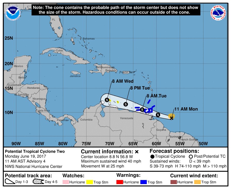
New warnings are up as Potential Tropical Cyclone #2 moves west towards the Caribbean. The government of Venezuela has issued a Tropical Storm Warning for the east coast of Venezuela from Pedernales to Cumana including Isla de Margarita. The government of the Netherlands has issued a Tropical Storm Watch for Bonaire. The government of Aruba has issued a Tropical Storm Watch for that country. While these new warnings are up, the government of St. Vincent and the Grenadine Islands has discontinued the Tropical Storm Warning for that country. A Tropical Storm Warning means that tropical storm conditions are expected somewhere within the warning area, in this case within 24 hours while a Tropical Storm Watch means that tropical storm conditions are possible within the watch area, generally within 48 hours.
As of 11am AST, the disturbance which has potential to become a tropical cyclone soon was centered near latitude 8.8 North, longitude 56.8 West. The system is moving toward the west near 25 mph. A fast motion toward the west-northwest is expected over the next 48 hours. On the forecast track, the disturbance is expected to move through the Windward Islands and near the eastern coast of Venezuela tonight and early Tuesday.
Maximum sustained winds are near 40 mph with higher gusts. Some strengthening is expected during the next 48 hours, and the disturbance is forecast to be a tropical storm when it moves through the Windward Islands and eastern Venezuela tonight and Tuesday.
Thunderstorm activity associated with the disturbance continues to show signs of organization, and additional development is likely during the next day or so. In their latest briefing, the National Hurricane Center forecasts a 90% chance that this system will become a tropical cyclone within the next 48 hours.