The National Hurricane Center is monitoring a tropical disturbance in the central Atlantic Ocean. While the 2017 Atlantic Hurricane season doesn’t begin until June 1, systems do pop up from time to time during the “off-season.”
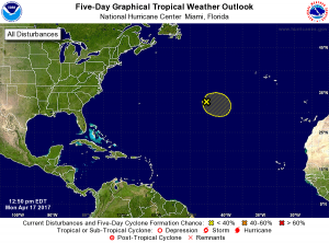
A non-tropical low pressure system located over the central Atlantic about midway between Bermuda and the Azores Islands is producing an area of gale-force winds to the west of the center. This low is currently producing only limited shower activity, but environmental conditions could favor additional development and this system has some potential to become a subtropical cyclone over the next day or
so as it moves generally eastward.
Less than two weeks ago, Dr. Philip Klotzbach, a Research Scientist in the Department of Atmospheric Science at Colorado State University (CSU), shared their analysis and forecast before a crowd of enthusiastic meteorologists at the 2017 Tropical Weather Conference. The 2017 forecast calls for a less active Atlantic Hurricane Season, with 11 storms expected; the seasonal norm is 12. The forecast calls for 4 hurricanes over 16 hurricane days; typically, there’s 6.5 hurricanes over 21.3 days.
