Tropical Storm Nicholas, which could strengthen to hurricane status before striking land, is forecast to bring epic amounts of rain to portions of Texas and Louisiana which will likely lead to significant flooding. Beyond flooding, Nicholas is forecast to bring storm surge flooding, damaging wind gusts, and the threat of isolated tornadoes.
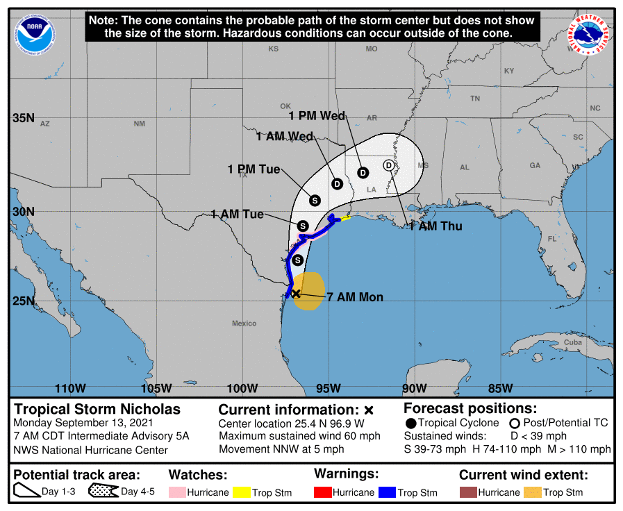
Right now, Nicholas is located about 40 miles south-southeast of the mouth of the Rio Grande River and about 210 miles south of Port O’Connor Texas. The storm has maximum sustained winds of 60 mph and is drifting to the north-northwest at 5 mph.
With the arrival expected soon, the National Hurricane Center is maintaining Storm Surge and Tropical Storm Watches along with a Hurricane Watch. The Storm Surge Warning is up for Port Aransas to San Luis Pass in Texas, including Aransas Bay, San Antonio Bay, and Matagorda Bay. The Tropical Storm Warning is in effect from the mouth of the Rio Grande River to High Island, Texas. The Hurricane Watch is in effect from Port Aransas to Freeport, Texas. A Storm Surge Watch is also up for the area between the mouth of the Rio Grande River to Port Aransas, Texas, from San Luis Pass, Texas to Rutherford Beach, Louisiana, Galveston Bay, Baffin Bay, and Corpus Christi Bay.
A Storm Surge Warning means there is a danger of life-threatening inundation, from rising water moving inland from the coastline,
during the next 36 hours in the indicated locations. The National Hurricane Center warns, “This is a life-threatening situation. Persons located within these areas should take all necessary actions to protect life and property from rising water and the potential for other dangerous conditions. Promptly follow evacuation and other instructions from local officials.”

A Tropical Storm Warning means that tropical storm conditions are expected somewhere within the warning area.
A Storm Surge Watch means there is a possibility of life-threatening inundation, from rising water moving inland from the coastline, in the indicated locations during the next 48 hours.
A Hurricane Watch means that hurricane conditions are possible within the watch area.
The National Hurricane Center believes Nicholas will move at a faster forward speed today, with an eventual north-northeastward turn tomorrow. On the forecast track, the center of Nicholas will pass near or just offshore the coasts of northeastern Mexico and south Texas this morning, and move onshore along the coast of south or central Texas late this afternoon or evening.
While maximum sustained winds are near 60 mph with higher gusts now, the National Hurricane Center expects strengthening today. It is possible that Nicholas will reach the northwest Gulf coast as a hurricane. Weakening is anticipated on Tuesday and Wednesday while Nicholas moves over land.
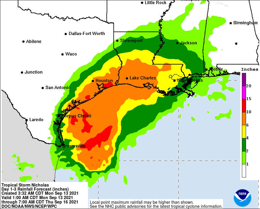
Even if Nicholas doesn’t become a hurricane, potentially devastating flooding is possible from the moisture-rich system. Nicholas is expected to produce storm total rainfall of 8-16″, with isolated maximum amounts of 20″, across portions of the middle and upper Texas coastal areas through the middle of the week. Across the rest of coastal Texas into southwest Louisiana rainfall of 5-10″ is expected. This rainfall may
produce areas of considerable flash and urban flooding, especially in highly urbanized metropolitan areas. Additionally, there is the potential for isolated minor to moderate river flooding.
The combination of a dangerous storm surge and the tide will cause normally dry areas near the coast to be flooded by rising waters moving inland from the shoreline. If the peak surge occurs at the time of high tide, a 3-5′ storm surge is possible. Even a storm surge of 1-3′ is possible well east of the storm over portions of Louisiana. The deepest water will occur along the immediate coast in areas of onshore winds, where the surge will be accompanied by large and dangerous waves. Surge-related flooding depends on the relative timing of the surge and the tidal cycle, and can vary greatly over short distances.
Tropical storm conditions are expected to first reach the coast within the warning area in northeastern Mexico and southern Texas this morning, making outside preparations difficult or dangerous. These conditions will spread northward within the warning area through tonight. Hurricane conditions are possible in the Hurricane Watch area as early as this afternoon. Tropical storm conditions are possible within the watch area by tonight or early Tuesday.
As with any landfalling tropical cyclone, there will be a threat of isolated tornadoes along the coast, with a growing threat of tornadoes as the storm moves over land.