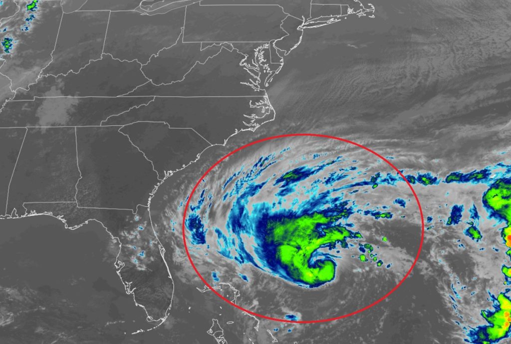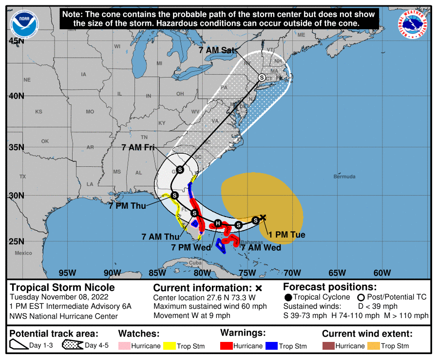
Nicole has completed its transition from a Subtropical Cyclone to a Tropical Cyclone, becoming officially a Tropical Storm; Nicole continues to get stronger and larger and is forecast to become a hurricane soon, prompting the National Hurricane Center to begin issuing Hurricane Warnings for the U.S. East Coast.
Right now, Nicole is located about 310 miles northeast of the Northwestern Bahamas and about 420 miles east of West Palm Beach, Florida. Maximum sustained winds are up to 60 mph while pressure is down significantly from yesterday to 992 mb or 29.29″.
A Hurricane Warning is in effect for the Abacos, Berry Islands, Bimini, and Grand Bahama Island in the northwestern Bahamas and for the Florida coastline from Boca Raton to the Flagler/Volusia County Line. A Tropical Storm Warning is in effect for Andros Island, New Providence, and Eleuthera in the northwestern Bahamas, and many places in Florida: Hallandale Beach Florida to Boca Raton Florida, the area from the Flagler/Volusia County Line in Florida to the Altamaha Sound in Georgia, and for Lake Okeechobee. A Storm Surge Warning is in effect for North Palm Beach, Florida to Altamaha Sound, Georgia and for the area around the mouth of the St. Johns River to Georgetown, Florida.
Warnings carry different meanings. A Hurricane Warning means that hurricane conditions are expected somewhere within the warning area. A warning is typically issued 36 hours before the anticipated first occurrence of tropical-storm-force winds, conditions that make outside preparations difficult or dangerous. Preparations to protect life and property should be rushed to completion. A Tropical Storm Warning means that tropical storm conditions are expected somewhere within the warning area within 36 hours.
A Storm Surge Warning means there is a danger of life-threatening inundation, from rising water moving inland from the coastline, in the warning areas. The National Hurricane Center warns, “This is a life-threatening situation. Persons located within these areas should take all necessary actions to protect life and property from rising water and the potential for other dangerous conditions. Promptly follow evacuation and other instructions from local officials.”
Watches are also in effect. A Hurricane Watch is in effect for the area from Hallandale Beach to Boca Raton, Florida, for Lake Okeechobee, and for the area from the Flagler/Volusia County Line to Ponte Vedra Beach. A Storm Surge Watch is in effect for the area south of North Palm Beach to Hallandale Beach, Florida, for the area between the Altamaha Sound in Georgia to the Savannah River, and for the area between the Anclote River in Florida to the Suwa

Hurricane conditions and a dangerous storm surge are expected in portions of the northwestern Bahamas on Wednesday, where a Hurricane Warning is in effect. Hurricane conditions are expected across portions of the coast of southeast and east-central Florida beginning late Wednesday or Wednesday night, where a Hurricane Warning has been issued. Tropical storm conditions are expected in the Tropical Storm Warning areas in Florida and Georgia beginning early Wednesday.
A dangerous storm surge is expected along much of the east coast of Florida and portions of coastal Georgia where a Storm Surge Warning is in effect. The storm surge will be accompanied by large and damaging waves. Residents in the warning area should listen to advice given by local officials.
The National Hurricane Center warns: “Do not focus on the exact track of Nicole since it is expected to be a large storm with hazards extending well to the north of the center, outside of the forecast cone. These hazards are likely to affect much of the Florida peninsula and portions of the southeast United States.”
Nicole will produce heavy rainfall Wednesday and Thursday across the Florida Peninsula. Flash and urban flooding will be likely with possible river rises on the St. Johns River. Flash, urban and small stream flooding will be possible in Southeast Georgia and portions of South Carolina Thursday into Thursday night.
After battering the southeast, Nicole is now forecast to move into the heavily populated area of the Mid Atlantic, producing flooding rains, storm surge flooding, coastal erosion and flooding, widely scattered tornadoes, and straight-line wind damage.
The latest forecast puts the center of Nicole over southeastern Georgia by Friday morning and then races is into the New York City metro area by early Saturday, bringing the center of circulation over central South and North Carolina, eastern Virginia and Maryland, northern Delaware, central New Jersey, and southeastern New York. Residents in these areas in the east should make preparations now for storm conditions expected for the end of the week.