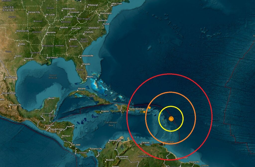
According to the National Weather Service’s Pacific Tsunami Warning Center, there are no tsunami threats at this time from a series of strong earthquakes that have rocked the Caribbean near the islands of Guadeloupe, Saint John’s, Dominica, and Martinique today. The earthquakes, all located within 10 miles of each other, started at 8:38 am this morning East Coast time and have continued through 6:16 pm this evening. The first was rated a magnitude 6.8 event although USGS re-evaluated it and reduced it to a still powerful magnitude 6.5 event. The nex strongest t event was a magnitude 6.0, followed by a magnitude 5.4, a magnitude 4.9, and a magnitude 4.6 earthquake. All of the earthquakes struck from a depth of only 10 km. In total, there have been 20 earthquakes in the area today; all were a magnitude 3.5 or greater earthquake.
While the event occurred within the Atlantic hurricane basin, tsunami bulletins for this seismic event were issued by the Honolulu, Hawaii-based office of the National Weather Service Pacific Tsunami Warning Center. Within 15 minutes of the first earthquake, they issued a bulletin to those along the Gulf of America and U.S. East Coasts that said, “An earthquake with a preliminary magnitude of 6.8 occurred in the Leeward Islands…based on all available data, there is no significant tsunami threat from this earthquake. However, there is a very small possibility of tsunami waves along coasts located nearest to the epicenter.” The Tsunami Warning Center issued 7 bulletins today with regards to today’s unusual seismic event.
Tsunamis are giant waves caused by earthquakes or volcanic eruptions under the sea. Out in the depths of the ocean, tsunami waves do not dramatically increase in height. But as the waves travel towards land, they build up to higher and higher heights as the depth of the ocean decreases. The speed of tsunami waves depends on ocean depth rather than the distance from the source of the wave. Tsunami waves may travel as fast as jet planes over deep waters, only slowing down when reaching shallow waters. While tsunamis are often referred to as tidal waves, this name is discouraged by oceanographers because tides have little to do with these giant waves.
 A tsunami is a series of waves. The time between wave crests can vary from 5 minutes to an hour. The hazard may persist for many hours or longer after the initial wave. Impacts can vary significantly from one section of coast to the next due to local bathymetry and the shape and elevation of the shoreline. Impacts can also vary depending upon the state of the tide at the time of the maximum tsunami waves.
According to USGS, there has been no other seismic activity near today’s earthquakes over the last 3 weeks.
The Leeward Islands are located on the Caribbean Plate, at the boundary with the North American Plate. This is a region of complex tectonic interactions where the North American plate subducts beneath the overriding Caribbean plate, forming the Lesser Antilles island arc. The North American plate is subducting under the Caribbean plate to the east of the islands, causing the volcanic activity that formed the arc.
This area is also home to the Lesser Antilles Volcanic Arc. This geographic boundary runs from the Virgin Islands in the north to the islands to off the coast of Venezuela in the south. This boundary contains seventeen active volcanoes, most notably Soufriere Hills on Montserrat, Mount Pelée on Martinique, La Grande Soufrière on Guadeloupe, Soufrière Saint Vincent on Saint Vincent, and the submarine volcano “Kick ’em Jenny” which lies just north of Grenada.
A recent seismic swarm at the Kick ’em Jenny submarine volcano was in the news earlier this summer. Beginning in late August 2025, the area saw hundreds of tremors with magnitudes between 2.2 and 2.4. Although the activity has since decreased significantly, the volcano remains at an elevated yellow alert level and marine vessels are still required to stay away from the volcano.
The UWI (University of the West Indies) Seismic Research Centre is the official source of information on earthquakes and volcanoes in the English-speaking Eastern Caribbean. They released this comment today: “The UWI-SRC continues to monitor the seismic activity observed north east of the island arc, east of Guadeloupe. These events do not meet the parameters for posting via the automatic solution algorithm based on their locations. Seismic technicians will be manually posting events from this area to our social media platforms. We expect aftershocks to continue and will update the interactive map on our website accordingly.” That map is located here.
