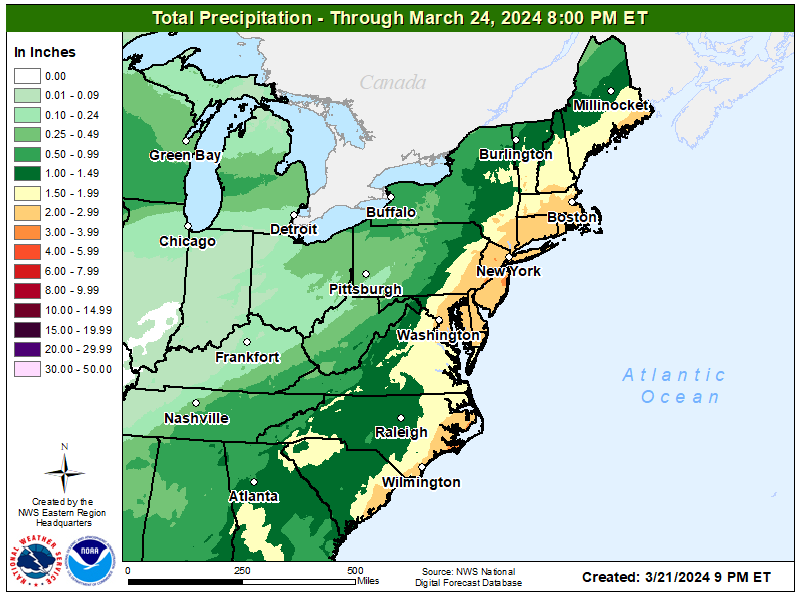
A strong coastal storm in the form of a nor’easter will bring areas of heavy rain, strong winds, and even snow to portions of the northeast starting Friday evening through early Sunday morning. It now appears New Jersey will bear the brunt of the heaviest rains with 2.5-3.5″ of rain expected there; meanwhile, more than 8″ of snow is likely across northern Vermont, New Hampshire, and Maine from this same storm.
The worst of the rain is expected near the I-95 corridor across New Jersey, there even isolated amounts of 4″ are possible from this storm. Due to the hazards expected from this rain, the National Weather Service has issued Flood Watches for locations at greatest risk to see the greatest impacts from excessive rainfall.
Rain will begin spreading into the Mid Atlantic from south to north Friday night, especially after midnight. The heaviest rain will begin to develop by Saturday, especially during the afternoon when some frontogenetic forcing from the nearby surface low will be most prevalent as well as the highest atmospheric moisture amounts. This set-up will create peak rainfall rates near 0.25-0.5″ on Saturday, especially over portions of New Jersey, Delaware, and Long Island. The rain will taper off from southwest to northeast by late Saturday afternoon and evening.
The National Weather Service says, “This is the type of heavy rainfall that may lead to standing flood waters in flat, low-lying areas across the coastal plain, minor poor drainage flooding in urbanized areas, and flooding of creeks and streams.” They also warn, “Both the Passaic and Raritan River basins are at risk for minor to moderate flooding this weekend. “
Breezy to windy conditions will develop on Saturday along the coast as the low strengthens with south-southeast winds around 30 mph with gusts around 40 mph possible. More widespread winds are expected late Saturday into Saturday night as the surface low pulls away from the area and cold and dry air advection quickly ramps up. Northerly winds are forecast to peak around 20-25 mph with peak gusts of 35-45 mph possible. Given the very saturated soils with the preceding heavy rainfall, these winds may lead to some downed trees and power outages.
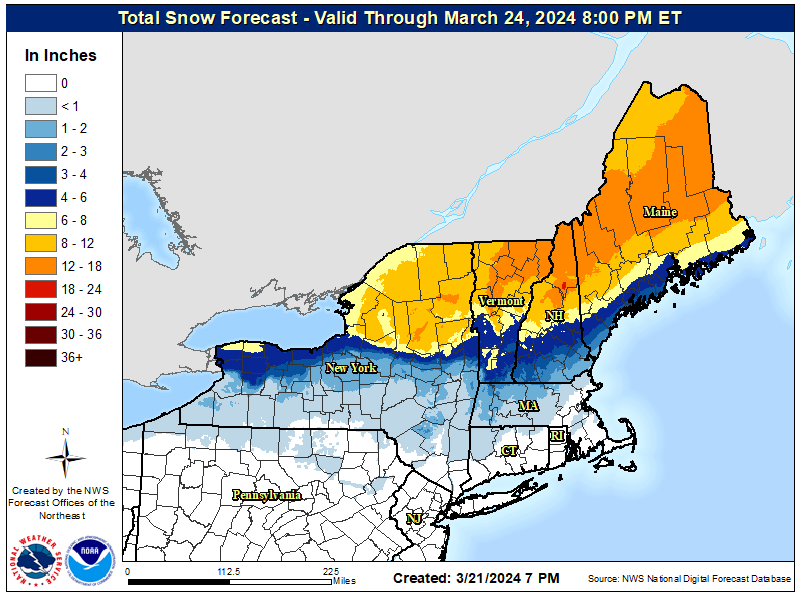
While this precipitation falls as rain in most location, that won’t be the case across northern New England where it will fall as snow. Snow is possible in southern upstate New York, northern Connecticut, and western and central Massachusetts. But the most significant snow will fall across northern New York, central and northern New Hampshire and Vermont, and the northern two-thirds of Maine. In the heaviest snow areas, 1 to 1.5 feet of snow are possible.
Rain will end Saturday night over the Mid Atlantic while snow will exit New England early on Sunday. Dry high pressure will build in from the north and west during the day on Sunday. While temperatures will be cool, northerly winds will gradually diminish throughout the northeast during the afternoon and evening hours on Sunday, making it not feel as cool as it would earlier in the day.
