People from North Carolina to New Jersey are on alert as a potentially significant coastal storm is taking shape. Strong winds, heavy, soaking rains, and rough surf with beach erosion and coastal flooding will be possible later this week, with the worst of the conditions arriving late Friday into Saturday. Both the National Hurricane Center in Miami, Florida and various National Weather Service offices along the east coast are monitoring the disturbance.
According to the National Hurricane Center, a non-tropical low pressure system is expected to form within a large area of disorganized showers and thunderstorms to the east of the Florida peninsula within the next day or two. This system could acquire some subtropical characteristics on Friday while it moves generally northward. Regardless of tropical or subtropical cyclone development, this low is likely to bring gusty winds to gale force, heavy rain, and high surf to portions of the Southeast and Mid-Atlantic United States late this week and into this weekend. Right now, the National Hurricane Center believes there’s a 40% chance that a subtropical storm will form here in the coming days, which is up from the 10% chance they suggested last night this time.
The National Weather Service says a subtropical storm typically has a large, cloud free center of circulation, with very heavy thunderstorm activity in a band removed at least 100 miles from the center. The difference between a subtropical storm and a tropical storm is not that important as far as the winds they can generate, but tropical storms generate more rain. There is no such thing as a subtropical hurricane. If a subtropical storm intensifies enough to have hurricane force winds, than it must have become fully tropical. The technical definition of a subtropical storm, according to the National Hurricane Center, is a “non-frontal low pressure system that has characteristics of both tropical and extratropical cyclones.”
The National Hurricane Center names both tropical storms and subtropical storms; the names are pulled from the same list of names to use for the hurricane basin each season.
The National Weather Service (NWS) office in Mount Holly, New Jersey, responsible for issuing forecast and advisories for most of New Jersey, eastern Pennsylvania, all of Delaware, and eastern Maryland, was more detailed in their latest Forecast Discussion with what to expect from this storm.
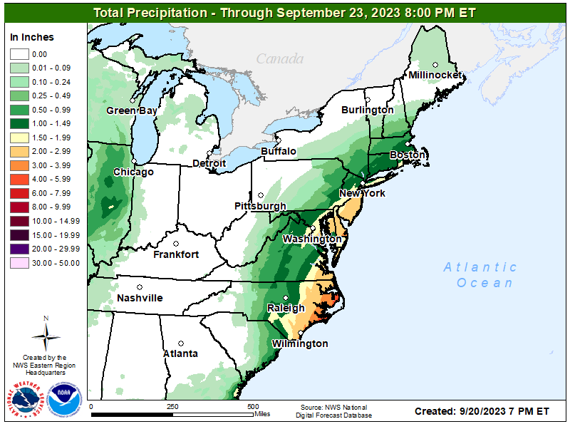
The New Jersey NWS office says that the low pressure system will move into the Mid-Atlantic by Friday afternoon, with a secondary low will spinning off of this primary low Friday night through Saturday. With abundant low level moisture in place across the region, periods of moderate to heavy rain are likely from late Friday night through Saturday afternoon, especially across Delmarva and southeast New Jersey, depending on where the low tracks. Showers will then continue through Saturday afternoon. It’s also possible there will be thunderstorms, especially across southern Delmarva and extreme southeastern New Jersey during this event.
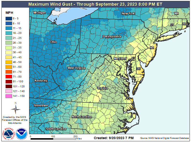
“A tight east to northeast gradient will develop between that low and high pressure over the Gulf of Maine, and a 45 to 55 kt low level jet will develop over the area,” the NWS warns. Winds will increase to 15 to 25 mph with gusts up to 35 mph, except winds will be stronger along the coasts, with 20 to 30 mph winds with 40 to 45 mph gusts. “A Wind Advisory may be needed for coastal New Jersey and coastal Delaware on Saturday,” the NWS said today.
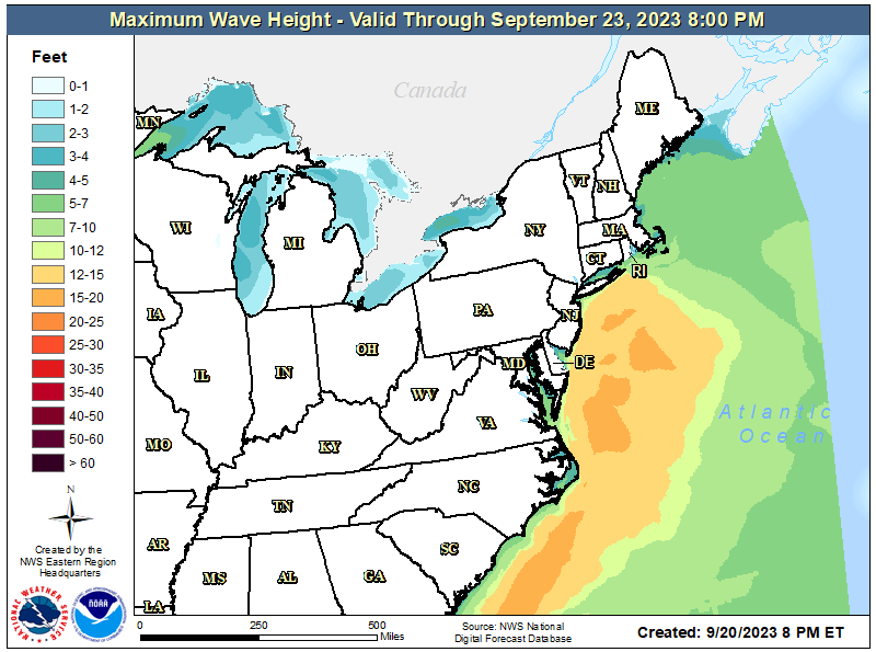
Dangerous rip currents, high surf, and beach erosion can be expected with this system. This weekend will be in between moon cycles, with the New Moon having occurred on September 14 and the Full Moon not occurring until 9/29. This should help keep coastal flooding on the lower side. High tides along the Atlantic coast will be between 2pm and 3pm. According to the NWS, at least minor to locally moderate coastal flooding can be expected during the times of high tide.
With the storm still more than 24 hours away from developing, there are no storm-related watches or warnings in effect at this time.
