The National Hurricane Center began issuing advisories for the first storm to form for the 2020 Atlantic Hurricane Season, which technically doesn’t begin until June 1. Known as Tropical Depression #1, the system is located off of the east coast of Florida and is becoming better organized over time. Hurricane Hunter aircraft investigating the storm system found that the structure of the system is improving; as such, the National Hurricane Center believes the system will become Tropical Storm Arthur tonight.
As of the latest update from the National Hurricane Center in Miami, Florida at 8:00pm ET, the center of Tropical Depression One was located by an Air Force Reserve reconnaissance aircraft near latitude 28.9 North, longitude 77.9 West. The depression is moving toward the northeast near 14 mph.
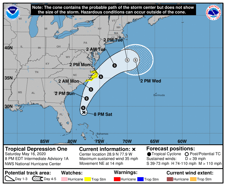
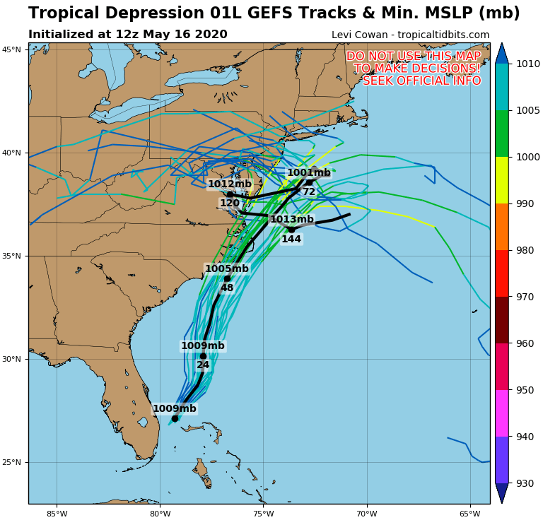
Where it goes over time remains in question. Most North American computer forecast guidance suggests Arthur would hug the Mid Atlantic coast, if not directly impact it. Meanwhile, European computer forecast guidance suggests the system will eject out to sea, saving the U.S. East Coast from much in the way of significant impacts. For now, the National Hurricane Center is leaning towards the European forecast model solutions and is officially calling for Arthur to maintain a motion toward the northeast or north-northeast tonight into Sunday morning and then a faster northeastward motion beyond that. Based on this forecast track, the depression is expected to remain well offshore the east coast of Florida and Georgia tonight and Sunday, and then move near or east of the coast of North Carolina on Monday.
Because of the uncertainty and the possibility that Arthur could impact the coast, the National Hurricane Center has issued a Tropical Storm Watch for the North Carolina coast from Surf City to Duck; the Pamlico and Albemarle Sounds are also included in the watch. A Tropical Storm Watch means that tropical storm conditions are possible within the watch area, generally within 48 hours. The National Hurricane Center says a Tropical Storm Warning could be required for portions of the watch area by Sunday morning.
For now, maximum sustained winds are near 35 mph with higher gusts. Gradual strengthening is forecast; beyond becoming a tropical storm tonight, Arthur is expected to achieve peak maximum sustained winds of about 45-55 mph over the next 48 hours. Arthur is not expected to intensify further into a hurricane at this time.
The minimum central pressure recently measured by a reconnaissance aircraft was 1006 mb or 29.71 inches.
While the Atlantic Hurricane Season doesn’t start until June 1, the National Hurricane Center is urging people to be properly prepared for the upcoming season. While NOAA won’t release their official seasonal outlooks until later this month, many other leading tropical weather forecasters are calling for a busy Atlantic hurricane season. With a busy season possible ahead, the National Hurricane Center recommends that people develop a written action plan, consider helping neighbors in their planning process, make sure their homes are strengthened prior to being threatened by a tropical system, make sure insurance is in-order, stock up on essential supplies, develop an evacuation plan, and ultimately identify and determine any risks you may face from a storm.
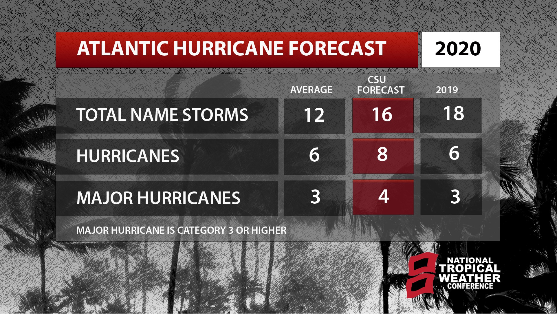
Experts with the Tropical Meteorology Project at CSU believe the upcoming hurricane season will be a particularly busy one with increased chances of a landfalling tropical system compared to typical seasons. NOAA is scheduled to unveil their official outlook for the season next week for both the Atlantic and Central Pacific hurricane basins and seasons.
