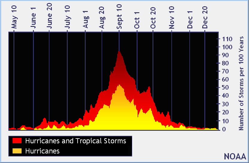
Today marks the typical peak of the Atlantic Hurricane season which begins on June 1 and runs through the end of November. Typically, this date marks more tropical cyclone activity in the basin more so than any other date when records of the last 100 years are studied. And right on time, the Atlantic is blossoming with activity, with two named storms and 4 other systems being tracked by the meteorologists at the National Hurricane Center in Miami, Florida.

The National Hurricane Center is issuing advisories on both Tropical Storm Paulette and Rene, the two named systems in the Atlantic basin. Rene is spinning about in the eastern Atlantic and is not forecast to impact land for at least the next 5 days as it spins about over open water. However, Paulette is forecast to strengthen to a hurricane and possibly impact Bermuda early next week. People in Bermuda should closely monitor that system, especially if hurricane watches or warnings are issued this weekend.
The remaining 4 systems are scattered across the basin, with one in the Gulf of Mexico, another in the western Atlantic near the Bahamas, another in the eastern Atlantic, and a robust system coming off the west coast of Africa now. Of the bunch, the system coming off the African coast is most likely to develop into a tropical cyclone. In fact, the National Hurricane Center says there’s a 90% chance of tropical cyclone formation here by the weekend or early next week. There’s also a medium chance that the system near the Bahamas will develop as it moves across Florida into the Gulf of Mexico.
The next system to be named will be Sally, followed by Teddy, Vicky, and Wilfred. Once those names are exhausted, the National Hurricane Center will use letters from the Greek alphabet to label storms.

In addition to being the peak of the Atlantic hurricane season, it’s also a traditionally busy time in the Pacific around the Central Pacific Hurricane Basin that surrounds Hawaii. However, at this time, the Central Pacific Hurricane Center in Honolulu on the island of Oahu expects no tropical cyclone activity in the basin for at least the next 5 days.
