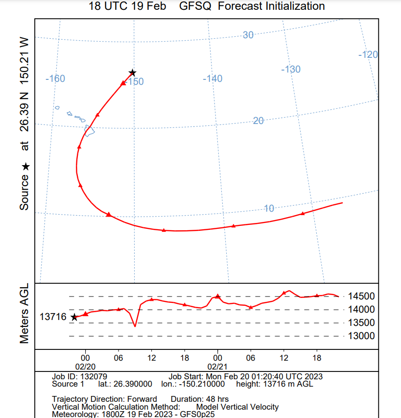
Earlier today, pilots were sending and receiving special warnings with regards to a large white balloon flying north and east of Hawaii. According to forecast models from the National Weather Service, the prevailing winds at the altitude the balloon was sighted at should bring it over the Big Island of Hawaii around midnight to 2 am early Monday morning local time (or roughly 5 am to 7 am Eastern Time Monday morning.) While it appears military aircraft from Honolulu, Hawaii are flying in the area of the balloon sighting, there has been no confirmation on why those aircraft are there and/or if their presence has anything to do with the balloon.
A message from the Oakland Oceanic Air Traffic Control Center on Sunday said a large white balloon had been reported over the Pacific Ocean, about 594 miles northeast of Honolulu. The balloon was reported to be flying at an altitude of roughly 40,000 to 50,000 feet in an area that is technically international airspace in between Hawaii and California; in this zone, the United States handles air traffic control.
Pilots and air traffic controllers have been using the Aircraft Communications Addressing and Reporting System, or ACARS for short, to alert each other of the presence of a balloon at an altitude many aircraft fly at. The ACARS system, used by all U.S. airlines, is a digital datalink system for transmission of short messages between aircraft and ground stations that are transmitted by radio or by satellite.
Today’s balloon incident comes just a week after the United States military shot down three unidentified flying objects over American and Canadian airspace. One of the objects believed to have been shot down include a $12 hobbyist balloon which was carrying a small payload consisting of a transmitter to allow hobbyists the opportunity to track its path as it circumnavigated the world almost 7 times.
Days before those mysterious objects were shot down, the U.S. also fired upon and destroyed a balloon launched from China just off the South Carolina coast. While China described that aircraft as a civilian weather balloon, the U.S. government said it was a spy balloon equipped with monitoring electronics that can snoop on areas below it.
A model from the National Weather Service suggests the balloon will move south and west towards the Big Island of Hawaii, crossing over the Kona side of the island at about 39,000 feet. From there, winds aloft would continue carrying the balloon well south of the island before it begins to curve east and eventually east-north-east. If the balloon is still flying at its forecast altitude, it could enter California airspace in the coming days.
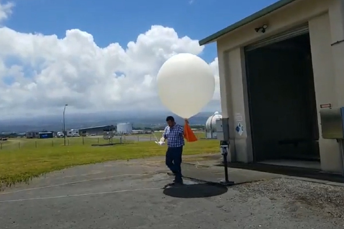
While there isn’t any official word on what the object is, most don’t believe it is a National Weather Service weather balloon. While the National Weather Service launches balloons across Hawaii and the United States at least twice a day, they are designed to travel up from their locations and pop, allowing for an instrument to collect weather data during its journey at different altitudes. That data is then fed into forecast models to create forecasts that meteorologists use to create weather forecasts.
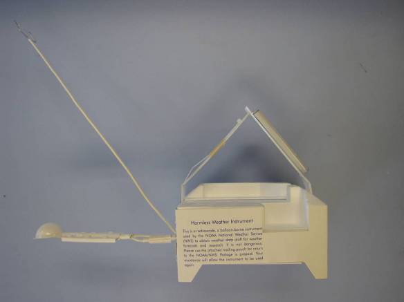
The National Weather Service weather balloon carries a device called a radiosonde high into the atmosphere to collect important data. The radiosonde is a small, expendable instrument package that is suspended about 80 feet below a large balloon inflated with hydrogen. As the radiosonde rises at about about 1,000 feet/minute, sensors on it measure profiles of pressure, temperature, and relative humidity. These sensors are linked to a battery powered radio transmitter that sends the sensor measurements to a sensitive ground tracking antenna. Wind speed and direction aloft are also obtained by tracking the position of the radiosonde in flight using GPS or a radio direction finding antenna. The radio signals received by the tracking antenna are converted to meteorological values and from these data significant levels are selected by a computer, put into a special code form, and then transmitted to data users. High vertical resolution flight data, among other data, are also archived and sent to the NOAA National Climatic Data Center.
When released, the weather balloon is about 5 feet in diameter. As it rises into thin air, it gradually expands as a result of the difference in air pressure with the balloon and the air that surrounds it. When the balloon reaches a diameter of 20 to 25 feet in diameter, it bursts. A small parachute slows the descent of the radiosonde, minimizing the danger to lives and property of the small lightweight device.
The radiosonde itself is made to be as environmental friendly as possible; it’s made of foam, cardboard, and a small amount of electronics. Even the parachute used to slow the radiosonde’s return to Earth is made up of photodegradable material. Hawaii National Weather Service Meteorologist Technician Michael Reilly told us, “We try to be as green as possible. There are components that are biodegradable. And on top is a bag attached that says, ‘remove bag for mailing instructions.’” People that find these radiosondes are encouraged to mail them back in the bag to NOAA for reconditioning and recycling. A reconditioning office will try to harvest as much of the radiosonde that wasn’t damaged in the fall, reusing it for future missions.
On Thursday, President Joe Biden said that the U.S. is updating its guidelines for monitoring and reacting to unknown aerial objects in light of the recent balloon drama that’s unfolded over North America in recent weeks. While the White House has been adamant that the Chinese balloon shot down near South Carolina was a spy craft, President Biden said officials suspect the three subsequent balloons were ordinary ones which could mean they were used for research, weather, recreational, or commercial purposes.
The White House and Pentagon have yet to comment on this new object approaching Hawaii Island.
