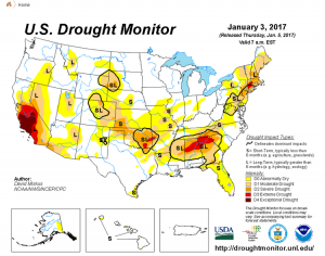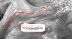
A plume of moisture arriving from the central Pacific, known by some as the “Pineapple Express”, is bringing incredible moisture to drought areas of the west. California, especially central/southern portions of the state, is in a severe drought, the result of a string of rainy seasons that did not produce the normal amount of precipitation. Agriculture has suffered and water rationing and bans have been put into place, especially in the Los Angeles and San Diego regions. A strong El-Nino brought slightly wetter than normal conditions last winter but did not come close to alleviating the long term drought situation. So far this winter has been a blockbuster in terms of mountain snow and low elevation rain for northern and central California. Currently the Sierra Nevada mountain range is experiencing a winter storm where more than five feet of snow will fall on top of five feet that has already accumulated.
Some impressive rain amounts from the base of the Sierra Nevadas in a 24 hour period ending at noon Wednesday include 3.56 inches in Chilkoot Meadow, 3.17 inches at Beartrap Meadow, 2.63 inches at Shaver Lake and 2.44 inches at Fish Camp.
Snow amounts have been equally impressive. As of noon Wednesdaym Northstar at Tahoe reported 42 inches of new snowfall in the previous 24 hours, 78 inches in the previous 48 hours, and a whopping one week total of 122 inches. Mammoth Mountain reported a storm total snowfall of 116 inches and 1 week total of almost 180 inches. Kirkwood Ski Resort has seen 48 inches of new snow, 71 inches in the past 2 days and 133 inches in the last 7 days.
This strong winter storm is a result of a weather pattern called the “Pineapple Express.” According to long range meteorologist David Samuhel, “The jet stream across the North Pacific has been strong this year. It has been much stronger, in fact, than recent years. Part of the reason is the water temperatures profile of the central and eastern Pacific. The water temperatures have cooled across much of the North Pacific. While, water temperatures are warmer further south towards the Hawaiian Islands. Jet streams thrive in the zone between warm and cold. So, this normal pattern is strengthening with warmer than normal water south of the Pacific Jet and colder than normal water to the north.”

This stronger than normal jet stream moves overhead the warm waters near Hawaii and heads just south of the cooler waters in the North Pacific. Because the jet stream originates from the tropics, it is loaded with deep tropical moisture and we get storms such as this one that are loaded with Pacific moisture. With its origins near Hawaii, this weather pattern and associated string of storms gets the moniker of the “Pineapple Express”.
Many of the mountains that make up the Sierra Nevadas have well over their normal snow water equivalent to date, some approaching or exceeding double their normal amount. Snow water equivalent is defined as the amount of water being stored in the snowpack.
According to seasonal energy and agriculture forecaster Ed Vallee, “An active Pacific Jet has increased the storm track across the west leading to ample precipitation. This regime looks to continue across the West through the end of January.” This will continue to allow the drought situation to improve as the snowpack continues to buildup and rain falls along the coast and at lower elevations. Unlike the East when most areas see rain all four of their seasons, California experiences almost all of their precipitation between November and March. Thus the melting snowpack from the mountains is the main source of water for drinking and agriculture during the warm months. Though the Sierra Nevadas are hundreds of miles away from both Los Angeles and San Diego, their water is one of two main sources of their water supply; the second is the Colorado River. Mr. Vallee adds, “After years of drought, this pattern should positively benefit the region’s water supply through the spring.” The quenching weather pattern may not last. “As we move into February we expect this pattern to shift drier. Even so, occasional storms will continue to impact the region,” says Mr. Vallee.
Though the total area covered by snow is actually somewhat less this year as compared to last, the Sierra Nevadas have deeper snow and the snow extends further down the mountains into lower elevations, especially after this ongoing blizzard. In some cases, the snow is much deeper. The deeper snow more than compensates for the slightly lower coverage area-wise. This is because the main source for water during the warmer months is the Sierra Nevadas, as the lesser mountains have much less snow during the winter and it melts off before it is needed.
The drought situation is thus slightly improved since this rainy season started out so well and the snowpack is being built up nicely. What additional impacts this pattern has to the long term drought crisis in southern and central California is yet to be seen.