It appears a potent nor’easter will visit portions of the northeastern U.S. in the coming days, bringing soaking rains to an area dealing with very dry or drought conditions. Computer forecast guidance is beginning to depict the possibility that a coastal storm will form during the middle of the week, lashing parts of the northeast with wind-whipped rains. However, not everywhere in the northeast will see precipitation from this storm system.
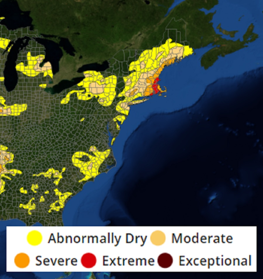
The summer of 2022 has been a very warm and dry one, evaporating a lot of the wet conditions that were around in a spring that was cooler and more moist than usual. According to Drought Monitor maps,much of the northeast and northern mid Atlantic regions are abnormally dry, with pockets of severe to extreme drought.
The U.S. Drought Monitor is a map released every Thursday, showing parts of the U.S. that are in drought. The map uses five classifications: abnormally dry (D0), showing areas that may be going into or are coming out of drought, and four levels of drought: moderate (D1), severe (D2), extreme (D3) and exceptional (D4). Since its creation in 1999, the Drought Monitor product is produced jointly by the National Drought Mitigation Center (NDMC) at the University of Nebraska-Lincoln, the National Oceanic and Atmospheric Administration (NOAA), and the U.S. Department of Agriculture (USDA). The NDMC hosts the web site of the drought monitor and the associated data, and provides the map and data to NOAA, USDA and other agencies.
In two weeks, the Drought Monitor maps may look very different, thanks in part to low pressure moving into the northeast this week.
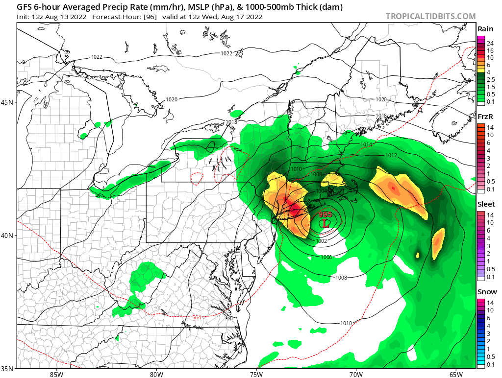
A broad upper trough, and at times, closed low, is forecast to remain over the northeast through next week before weakening next weekend. High pressure is forecast to weaken on Monday as a series of low pressure systems begin to track south of the area into the middle of the week. Monday’s low currently is forecast to track well south of New York City, with precipitation then confined to portions of the Mid Atlantic. However, Tuesday’s tracks a little farther to the north, with computer forecast guidance, such as the American GFS forecast model, in better agreement with a deeper low projecte to pass south and east of the region Wednesday morning before retrograding into the northeast by the afternoon. This retrograding action is possible as the upper trough closes-off and becomes negatively tilted, a meteorological situation more common in autumn months than mid-August.
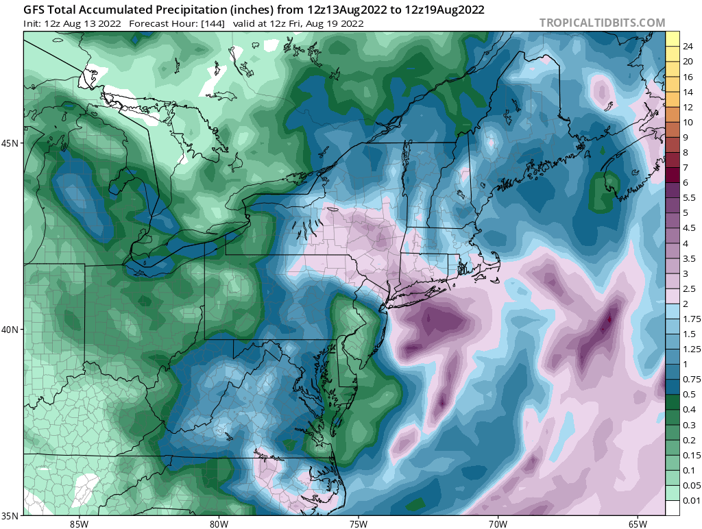
The National Weather Service, which is tracking the developing system, cautions that there is uncertainty as to how far west the low will track. Right now, it appears far northeastern New Jersey, the New York City metro area, and central and eastern Upstate New York will be the western extent of precipitation from this system. The heaviest is likely to be over portions of Long Island, Connecticut, Rhode Island, and Massachusetts, all areas that desperately need a good, soaking rainfall. Unfortunately, those beneficial rains could be joined by high winds, rough seas, beach erosion, and the threat of coastal flooding.
This low pressure system will also keep it cooler than normal. With a cool easterly flow developing Monday and continuing into Tuesday night, then becoming more northerly Wednesday into Thursday, temperatures will likely be slightly below seasonal normals. The cool-down will be brief though; as the nor’easter departs the northeast on Thursday, dry weather, high pressure, and a west southwest flow will return. This will help drive temperatures back to seasonal normals, if not above normal levels, by Friday and Saturday.
and Saturday, and used the NBM.