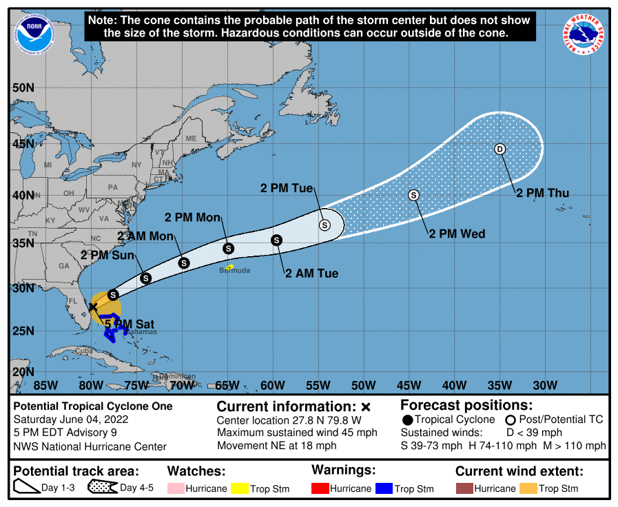
While the National Hurricane Center initially thought Potential Tropical Cyclone #1 would develop into Tropical Storm Alex prior to impacting Florida last night, that did not happen; however, Florida was still lashed by strong, gusty winds and heavy, flooding rains. Now, questions remain with where this system will go and how strong it’ll get in the coming days now that it has completely crossed Florida.
According to the National Hurricane Center (NHC) in Miami, Florida, RADAR data and surface observations indicate that the circulation of the disturbance has become a little better defined since the last advisory, although the central area still consists of an area of multiple vorticity maxima extending from near Lake Okeechobee east-northeastward into the Atlantic. While the current structure still does not justify an upgrade to a tropical storm, the easternmost of these centers is near the main convective area, and if this continues, the NHC says the system could become a tropical storm in the next 6-12 hours. Based on Air Force Reserve Hurricane Hunter observations, the intensity of the system has increased somewhat.
In the short term, the NHC says that the track guidance remains in good agreement that a general northeastward motion should continue through Sunday, followed by an east-northeastward to eastward motion on Monday and Tuesday. On the forecast track, the system will move away from Florida tonight, and then pass north of Bermuda on Monday on its way into the central Atlantic.
With the system potentially passing near Bermuda as a tropical storm, the government there has issued a Tropical Storm Watch.
While the system isn’t named yet, when it does reach Tropical Storm status due to its structure, it will be named Alex.
Water vapor and air mass imagery show a mid- to upper-level trough over the southeastern United States and the eastern Gulf of Mexico. While this trough continues to aid strong westerly shear over the disturbance, the NHC says that the interaction between this trough and the disturbance is forecast to lead to a better-defined circulation during the next 12-24 hours, which should allow the disturbance to become a tropical storm and strengthen a little.
However, large questions remain over the future of the storm. The National Hurricane Center says that in about 3 days, global computer forecast models have split the system into two, with a center that forms in the northern part of the circulation merging with a frontal system to become an extratropical low, while the rest of the system turns more southward and slows down well to the east of Bermuda.
The NHC cautions: “Given the uncertainty, there will be no changes at this time from the previous forecast of extratropical transition and the associated track forecast. However, there is now an alternate scenario that may require changes to the track and intensity forecasts in later advisories.”
With that said, people along the U.S. East Coast, Bermuda, and the Bahamas should closely monitor the future progress of this system in the coming days.