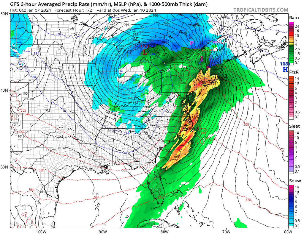
A well-advertised powerful storm is due to lash the eastern United States in the coming days with flooding rains, strong winds, and severe storms. And despite this weekend’s significant snowfall in portions of the northeast, the rain/snow line will advance north to the border with Canada, dumping heavy rain on top of areas that saw heavy snow.
While the northeast will be digging out, this next impressive storm will be making its way through the Rockies today. Heavy snow is likely across much of the Intermountain West and Central and Southern Rockies. Snow is also likely over the Northern Rockies but to a lesser extent. This system will reorganize over the Southern Plains on Monday and develop into a deep and dynamic mid-latitude cyclone.
This storm will generate heavy snow and strong winds over the Plains and
Midwest on Monday and Tuesday, producing more than a foot of snow over portions of the Midwest. Blizzard conditions are most likely in the Central Plains where wind gusts in excess of 50 mph will lead to near zero visibility at times and extremely dangerous travel. Blizzard conditions are possible in the Midwest as well; due to these threats, the National Weather Service has already issued Winter Storm Watches for parts of the Southern High Plains, Central Plains and Middle Mississippi Valley.
While heavy snow will fall on the back side of the system, milder air will push north ahead of it, creating a widespread and potentially significant river and flash flooding event from the central Gulf Coast through much of the Eastern U.S. early this week. Powerful onshore winds will lead to widespread coastal flooding along the eastern Gulf Coast and much of the East Coast. Significant coastal flooding is likely in some areas, especially in the Carolinas and
Mid-Atlantic. There is even a risk of severe thunderstorms with large hail, damaging wind gusts, and isolated tornadoes Monday through Monday night across parts of southeast Texas, southern Louisiana, southern Mississippi, and southern Alabama into the western Florida panhandle. By late Monday night, damaging wind gusts and tornadoes are possible across those areas and advance into the southeastern U.S. by Tuesday.
The National Weather Service warns, “Widespread wind gusts in excess of 50 mph are likely in the eastern Gulf Coast so prepare for power outages.” Strong damaging wind gusts are also possible up and down the eastern U.S. from New York south to Florida as the storm pushes east.
