
Residents from Florida to New Jersey should be bracing for the impacts that’ll arrive in the coming days from Hurricane Michael. At 5am this morning, the National Hurricane Center (NHC) classified an area of disturbed weather as Tropical Depression #14. This area is forecast by the NHC to grow into Tropical Storm Michael and eventually Hurricane Michael prior to hitting the U.S. Gulf Coast. Michael is then expected to move up the eastern U.S., bringing the potential for storm surge flooding, heavy rains and fresh water flooding, and wind damage to places as far north as New Jersey and the New York City metro area by the end of the week.
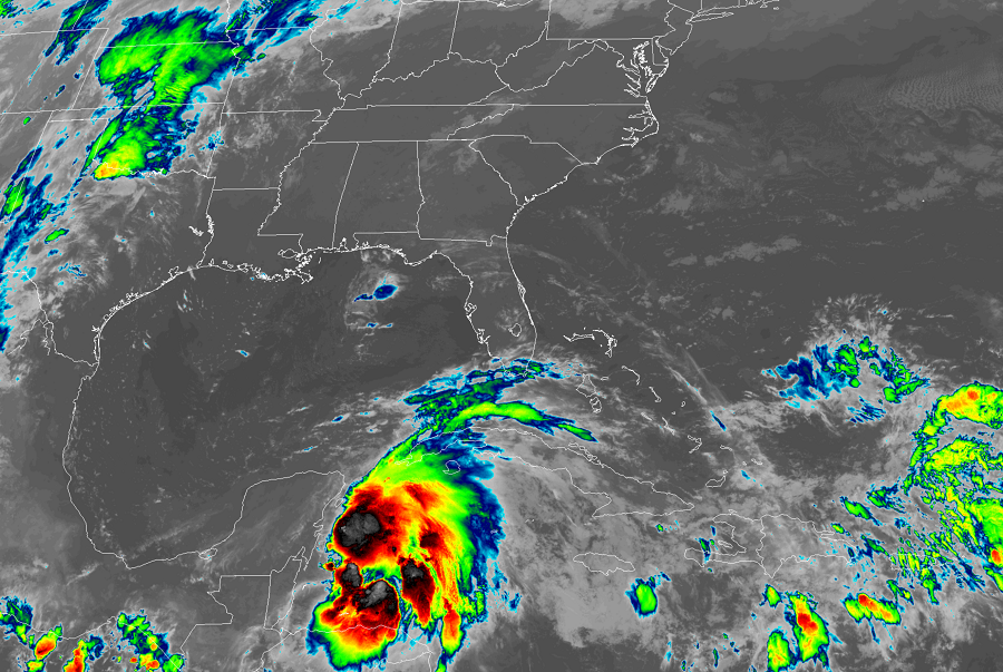
As of the latest advisory this morning from the NHC, the center of Tropical Depression Fourteen was located near latitude 18.6 North, longitude 86.9 West. The depression is drifting toward the north-northwest near 3 mph. The NHC is forecasting a turn toward the north later today, with that motion at a faster forward speed continuing through early Wednesday. On the current forecast track, the center will move through the Yucatan Channel Monday morning and then across the eastern Gulf of Mexico late Monday through Wednesday. Maximum sustained winds are near 35 mph with higher gusts.
Some strengthening is forecast during the next several days, with the depression expected to become a tropical storm later today. When Tropical Depression #14 is upgraded to a tropical storm with sustained winds of 39mph, it will be named Michael. Beyond intensifying to a tropical storm today, the NHC expects that the system will become a hurricane by Tuesday night or Wednesday. Michael could landfall as a hurricane on the Florida or Alabama coast as soon as late Wednesday or early Thursday.
After landfalling as a hurricane along the U.S. Gulf Coast, Michael is forecast into the general direction of the Mid Atlantic, bringing the threat of flooding rains into the southeastern U.S., including areas hit hard recently by Hurricane Florence. The NHC expects the system to maintain tropical storm strength as it approaches the Jersey Shore by Friday morning, with wind damage, storm surge flooding, and fresh water flooding from heavy rains possible in Delaware, New Jersey, and New York at the end of the week.
For now, the impacts from this developing tropical cyclone will be felt over portions of Central America and Cuba. Total rain accumulations of 3 to 7 inches are expected over western Cuba and 2 to 4 inches over the Yucatan Peninsula, Belize, and northern Honduras through Tuesday. Isolated maximum amounts of 12 inches are possible in western Cuba. A separate area of persistent very heavy rainfall is expected along the Pacific coast of Central America and Mexico, including western Nicaragua, El Salvador, Guatemala, and the state of Chiapas in Mexico. In many of these areas this rainfall could lead to life-threatening flash floods. Tropical storm conditions are expected to first reach the coast within the warning area by this evening or tonight, making outside preparations difficult or dangerous. Elsewhere, outer rain bands from the depression are expected to produce total rain accumulations of 2 to 4 inches across the Florida Keys through Monday.
Local governments have issued advisories for the storm; the U.S. has yet to issue anything for it yet, although that will likely change over time. For now, a Tropical Storm Warning is in effect for the Cuban provinces of Pinar del Rio and the Isle of Youth and the coast of Mexico from Tulum to Cabo Catoche. A Tropical Storm Warning means that tropical storm conditions are expected somewhere within the warning area, in this case within 24 hours.
Before any advisories are issued for the U.S., people from Florida to Louisiana on the Gulf Coast and from Florida to New York on the U.S. East Coast should make sure they have a Hurricane Action Plan in place. It is becoming likely that many in this area will need to act on it in the coming days as Michael becomes a serious threat to life and property.
