Puerto Rico residents, still dealing with the aftermath left behind by 2017’s Hurricane Maria, was rocked by a strong earthquake last night while it’s being blasted by an intensifying tropical storm today. A 6.0-magnitude earthquake struck near Puerto Rico Monday evening; the U.S. Geological Survey said the quake hit 49 miles off the island’s northwest coast at a shallow depth of 6 miles. Three aftershocks, with magnitudes of 4.7, 4.6 and another of 4.6, hit within less than an hour in the same region at the same depth. These quakes happened as Tropical Storm Karen picked up strength and headed to the island.
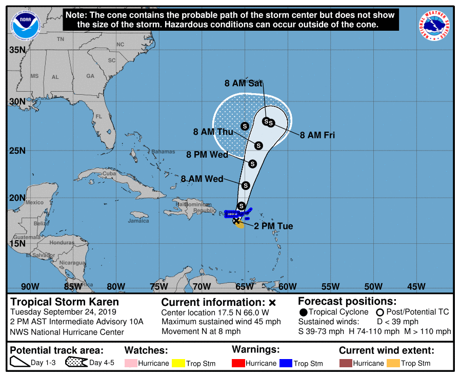
As of the 2pm update today from the National Hurricane Center (NHC), the center of Tropical Storm Karen was located near latitude 17.5 North, longitude 66.0 West. Karen has moved erratically during the past few hours as the center has re-formed a little to the west. However, it is expected to resume a motion toward the north near 8 mph this afternoon. A north-northeastward motion with some increase in forward speed is forecast tonight by the NHC through Wednesday night. On the forecast track, the center of Karen will pass near or over Puerto Rico and the Virgin Islands this afternoon and then move over the western Atlantic tonight and Wednesday.
Due to the storm’s arrival, a Tropical Storm Warning is in effect for the U.S. Virgin Islands, Puerto Rico, including Vieques and Culebra, and the British Virgin Islands. A Tropical Storm Warning means that tropical storm conditions are expected somewhere within the warning area.
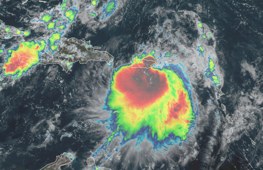
Reports from an Air Force Reserve Hurricane Hunter aircraft indicate that maximum sustained winds are now near 45 mph with higher gusts. Additional slow strengthening is expected by the NHC during the next couple of days. Tropical-storm-force winds extend outward up to 80 miles mainly to the southeast of the center. Surface observations indicate that wind gusts to tropical-storm force are occurring over portions of the Virgin Islands and southeastern Puerto Rico. The minimum central pressure estimated from Air Force Reserve Hurricane Hunter aircraft data and surface observations is 1005 mb or 29.68 inches.
Karen is expected to drop 2-4″ of rain across Puerto Rico with isolated amounts up to 8″. In the Leeward Islands, 1-3″ is expected, with some isolated amounts up to 5″ possible. These rains may cause flash flooding and mudslides, especially in mountainous areas.
Tropical-storm-force winds, especially in gusts, are currently spreading across the warning area. Winds could be higher on the windward sides of hills and mountains, and also in elevated terrain.
The National Guard also had been activated for the storm, and schools and government offices remained closed as heavy rains were forecast for Puerto Rico on Tuesday, with warnings of possible flooding and landslides.
The USGS warns that more after shocks from last nights quake are possible but cannot predict when or how strong they’ll be.
The last powerful quake to strike Puerto Rico was in January 2014, when a magnitude-6.4 tremor hit after midnight just north of the island’s north coast at a depth of 17 miles. Authorities reported broken windows, a busted water line and cracked floors and walls, along with some power outages. Some 70 aftershocks were reported, with at least three of a magnitude 3.5 or greater.
The most damaging earthquake to hit Puerto Rico in recorded history occurred in October 1918, a magnitude-7.3 quake that struck near the island’s northwest coast, causing a tsunami and killing 116 people.
