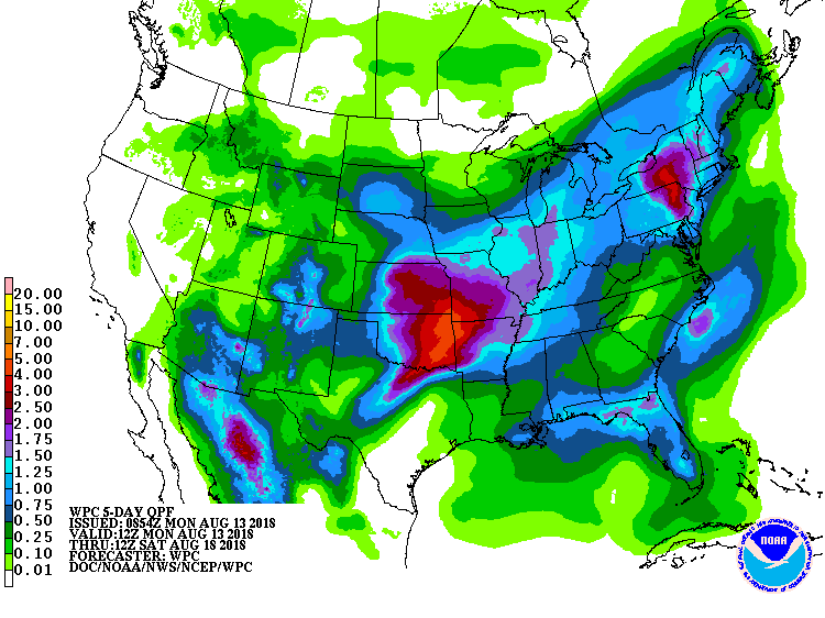
After a weekend rain event that created significant flash flooding in portions of New Jersey, Pennsylvania, and New York, it appears more of the same is happening and will be happening in the same general area. Flooding was so bad in portions of eastern Pennsylvania and southern New Jersey from morning rains today that people needed to be rescued by boat in some residential neighborhoods.
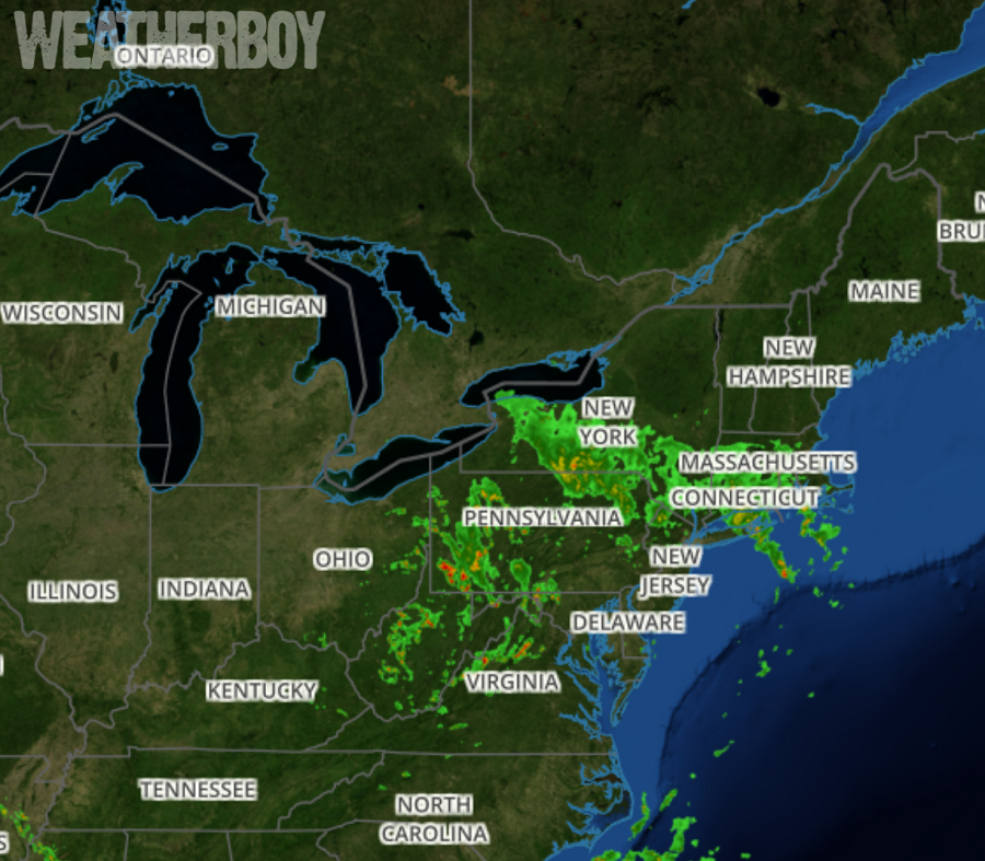
An area of showers with embedded thunderstorms continues to slowly push northward into the northeast today. Torrential rainfall is occurring with this cluster of storms and flash flooding is occurring. According to the National Weather Service, reports of 3 to 5 inches of rainfall have occurred with this mornings rainfall and any additional rainfall in these areas this afternoon and evening will lead to more flooding concerns.
Weather over the Mid Atlantic and Northeast will continue to be influenced by an upper low now located near the southwest corner of Pennsylvania. A trough axis appears to extend south from the low through the western Carolinas. A band of stronger convection has developed from the upper Chesapeake Bay
northward through the lower and middle Susquehanna Valley, possibly in association with a developing upper-level jet streak across that area. With daytime heating and de-stabilization, convection is expected to increase in coverage as we continue into the afternoon. Given the abundance of atmospheric moisture, slow-moving storms and wet antecedent conditions, the threat for localized flooding is significant and the flash flood watch remains in effect for areas generally along and northwest of the I-95/I-295 corridor. Temperatures today should be similar to yesterday with a very warm and humid air mass remaining over the area.

Tonight, the upper low is forecast to begin a slow northeast movement. Fairly widespread convection may be ongoing in the evening as low pressure moves slowly northeast along a frontal boundary across the area. Convection should diminish through late evening and overnight with loss of instability. However any storms lingering into the evening could still produce heavy rains and flooding.
After stalling near the Pennsylvania/Ohio border for more than 24 hours, the upper low is forecast to lift northeast toward the lower/mid-Hudson Valley tomorrow. At the surface, the same stationary front parked over the Mid Atlantic this weekend is expected to remain near the I-95 corridor, the coastal plain, or just offshore during this time. The exact position of this front will depend on the strength, timing and track of a weak wave of low pressure that is forecast to track northeast along the boundary. Large-scale lift ahead of the upper low and downstream upper level jet streak will keep showers and storms in the same area on Tuesday. The axis of heavy rainfall would most likely occur along and just west of the surface front as convergence along
this boundary could help focus convective development.

There should be a brief break in the wet weather later Tuesday night into Thursday, but another round of rain is likely. The next upper shortwave trough and surface low is expected to move through the Midwest and Great Lakes regions late in the week and then through the Northeast states next weekend. Chances for showers and storms will return to the Mid Atlantic from late Thursday through Sunday as the region remains under the influence of this disturbance. Greater convective coverage seems possible on Friday given the timing of the synoptic cold front. Highs each day will generally be in the mid 80s which is near normal for mid August. The exception will be Thursday and Friday, with highs in the upper 80s and lower 90s as pre-frontal warm sector becomes established in the Mid Atlantic.
Be sure to visit our Flood Information Center so that you are prepared before any threat arrives.
