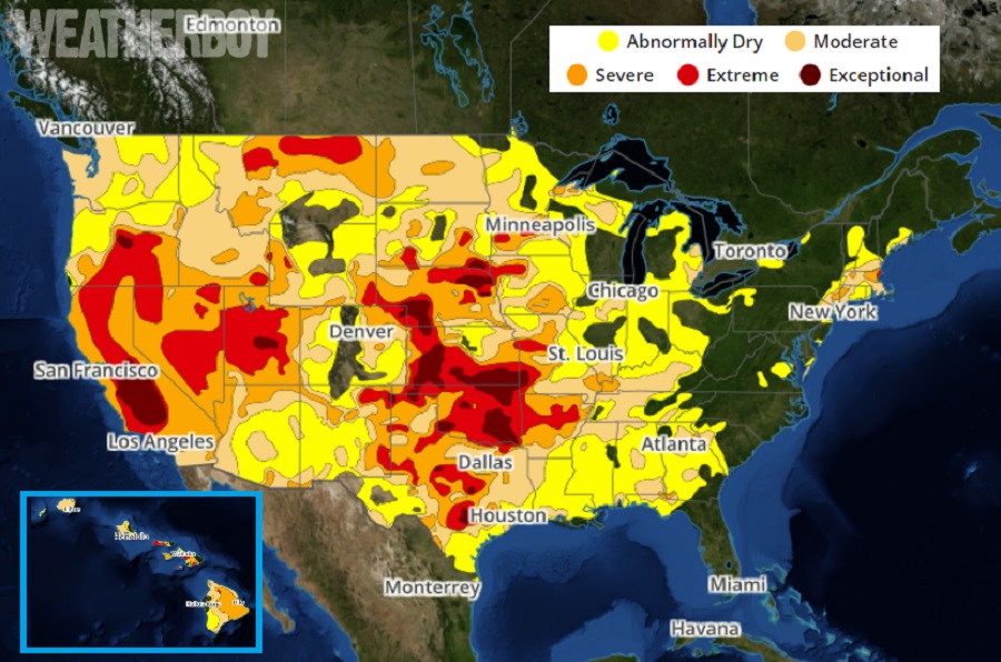
Areas of soaking rains have helped erase drought from the Drought Monitor maps across many parts of the country; from New Jersey to Hawaii, significant areas experiencing drought conditions aren’t any longer. However, pockets of the Central Plains and the west, especially central interior California, continue to experience exceptional drought. The U.S. Drought Monitor is produced through a partnership between the National Drought Mitigation Center at the University of Nebraska-Lincoln, the United States Department of Agriculture, and the National Oceanic and Atmospheric Administration. Maps and data are released on a weekly basis. Overall, while the amount of abnormally dry ground grew somewhat over the last 30 days for portions of the Mississippi and Ohio River Valleys and the interior South East, the amount of land covered by “Severe Drought” and “Extreme Drought” shrunk.
Rain associated with Hurricane Ian and its remnants added significant moisture to east coast soils, with most of the Mid Atlantic and Florida improving their Drought Monitor status.
In Hawaii, an unusually wet dry season, especially on western portions of Hawaii’s Big Island, helped to whittle away the drought there too. A month ago, 91.4% of Hawaii was experiencing some form of drought; that has dropped off to 76%.
Unfortunately, the news isn’t as good elsewhere in the country, with increasing dryness in the Midwest, High Plains, and West.
According to the National Drought Mitigation Center, increasing short-term precipitation deficits and declining soil moisture supported an expansion of abnormal dryness across Ohio, Indiana, and Illinois. Moderate drought was also expanded across Illinois along with streamflows along the Kankakee, Illinois, and Vermillion Rivers. A broad expansion of drought conditions was required throughout Kentucky due to a prolonged dry spell since August. According to the Paducah National Weather Service Office, Paducah had its driest August 1 – October 11 on record with only 2.12 inches of precipitation. Multiple reports from many counties in Kentucky, including Livingston, Fulton, Webster, Marion, Carlisle, Trigg, and Ballard, indicate poor pastures and low ponds. In addition, low flows persist along the lower Ohio River. The extreme drought expanded in northwestern Iowa. South of Lake Superior, severe drought areas were expanded due to a very dry summer.
Dryness and drought conditions also persist in the Midwest. Soil moisture indicators supported expansion of moderate drought conditions throughout northern and eastern North Dakota. Based on a consensus of indicators, severe drought was added to central North Dakota. Severe to extreme drought was expanded slightly across east-central Nebraska. Likewise, these indicators supported a 1-category degradation in parts of south-central and southwestern South Dakota. Impact reports from these areas of South Dakota include reports of zero soil moisture down to three feet on several fields and low stock ponds. The most widespread degradations made to Kansas were in northeast and east-central parts of the state. An expansion of abnormal dryness and moderate drought was made to southeastern Colorado based on a variety of factors including declining soil moisture and streamflows. Conversely, heavy rainfall of 1-2″ since the beginning of October prompted a 1-category improvement for parts of southwestern Colorado. Slight improvements were also justified across northwestern Wyoming where soil moisture levels improved.
In the West, increasing 90-day precipitation deficits of more than 6″ and above-normal temperatures during September resulted in the continued expansion of moderate drought region across western Washington and northwest Oregon. According to the National Center for Environmental Information’s statewide rankings, Montana had its warmest July-August-September on record. Based on the conditions there, extreme drought was expanded across northern Montana.
