A developing winter storm in the western United States will help set the stage for a period of likely record warmth across the eastern U.S. in the coming days. A developing winter storm that is expected to impact much of the western mountain ranges and central U.S. will bring much needed rain and snow to portions of the west, but it will also help surge unseasonably mild temperatures north across the eastern half of the country.
Short-wave energy, currently way out in the Pacific, will amplify and phase with a southern stream system as it enters the continental U.S. early tomorrow morning. As the associated upper-trough strengthens, a surface wave of low pressure will develop over the Intermountain West. This developing system will produce a swath of 8-12″ of snow extending from the Sierra Nevada, through the Intermountain West and into the Central Rockies on Thursday. Locally higher amounts are likely over the highest elevations of Utah and the northern Colorado Rockies, bringing the most significant snow so far in the young meteorological winter season. Additional snow will fall over the Central Rockies and Utah mountains on Friday as the surface low begins to deepen and ramp up precipitation over the Central Plains. Between 2-3 feet of snow is expected to accumulate over much of the Central Rockies by Saturday morning. A swath of lighter snow, around 4-8″, will develop in the cold sector of this system from the Front Range across the Central Plains and into the Upper Mississippi Valley on Friday.
Scattered thunderstorms, some severe, are expected to overspread much of the Deep South into the Midwest on Friday as the deepening system develops into a dynamic mid-latitude cyclone. The peak of severe thunderstorm activity will be during the afternoon and evening on Friday, with the most severe conditions expected across parts of the Lower and Middle Mississippi Valley and the Tennessee and Ohio Valleys due to increased instability caused by this system.
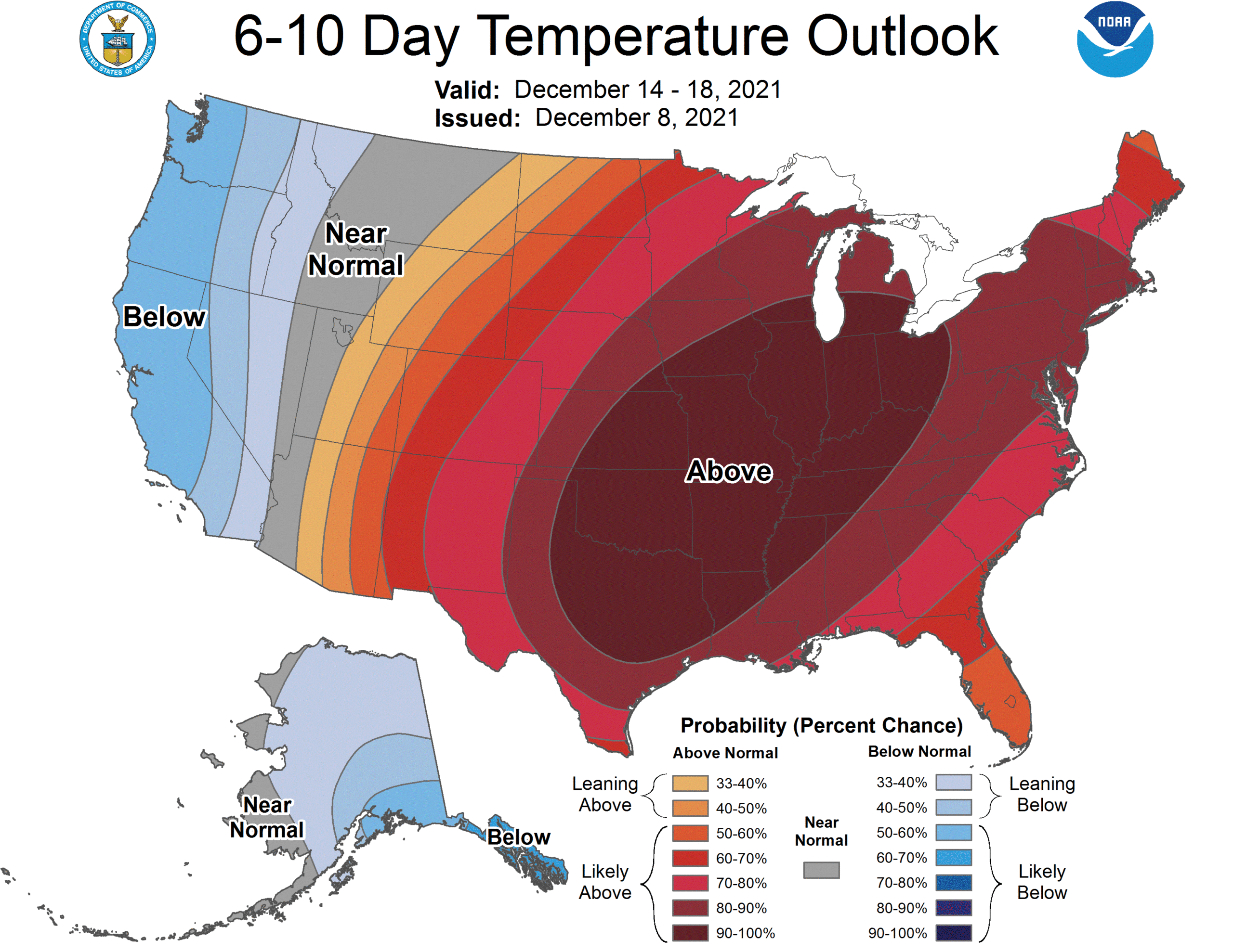
According to the National Weather Service, the approaching winter storm will generate a plume of anomalously warm air into the south-central U.S. and Midwest on Thursday and Friday before spreading that warmth into the eastern third of the country on Friday night into Saturday. Widespread temperature records may be set over much of eastern/central Texas through to the Lower/Middle Mississippi Valley on Friday as temperatures are expected to be between 20-30 degrees above average. Record breaking temperatures are likely to arrive over the eastern third of the country Friday night and Saturday with lows across the Southeast through Ohio Valley Friday night likely to be 25 30 degrees above average.
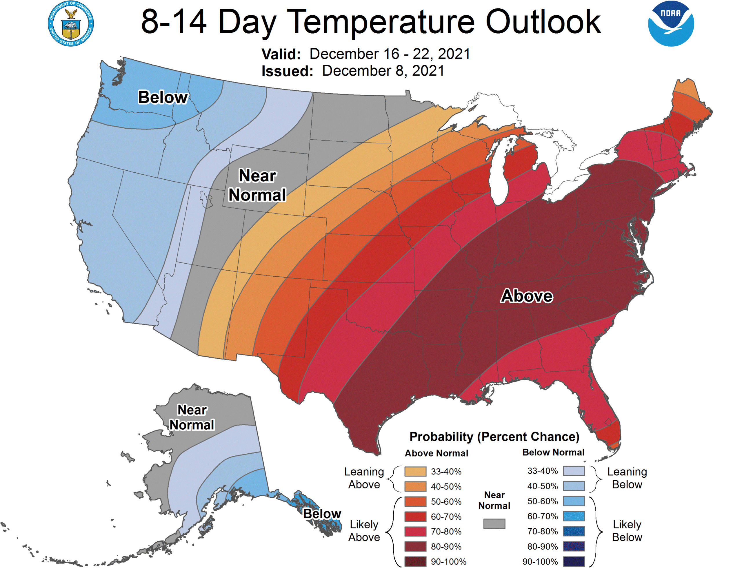
Looking beyond this weekend, the National Weather Service’s Climate Prediction Center also believes conditions will remain unseasonably mild over the eastern half of the country over the next 10-14 days.
The Outlooks issued by the Climate Prediction Center (CPC) gives the confidence that a forecaster has, given as a probability, that the observed temperature, averaged over upcoming days will be in the range of one of three possible categories – below (B), normal (N), or above (A). For any period, these categories can be defined by separating the 30 years of the climatology period, 1981-2010 (30 years), into the coldest 10 years, the middle 10 years, and the warmest 10 years. Because each of these categories occurs 1/3 of the time (10 times) during 1981-2010, for any particular period, the probability of any category being selected at random from the 1981-2010 set of 30 observations is one in three (1/3), or 33.33%. This is also called the climatological probability. The sum of the climatological probabilities of the three categories at any point on the map is 100%.
The colored shading on the CPC’s forecast maps indicate the degree of confidence the forecaster has in the category indicated, where “B” and blue colors indicate “below-normal” and “A” and orange-red colors indicate “above normal”. The darker the shading, the greater is the level of confidence. The numbers labeling the contours separating different shades gives the probability that the indicated category (A, B, or N) will occur.
The current weather pattern which will produce the Rocky Mountain snowstorm this week and mild weather in the east will likely persist for at least the next week or two, producing mild to warm conditions in the East as Christmas approaches. It is still too early to know if the pattern will modify or flip towards the end of the month.
