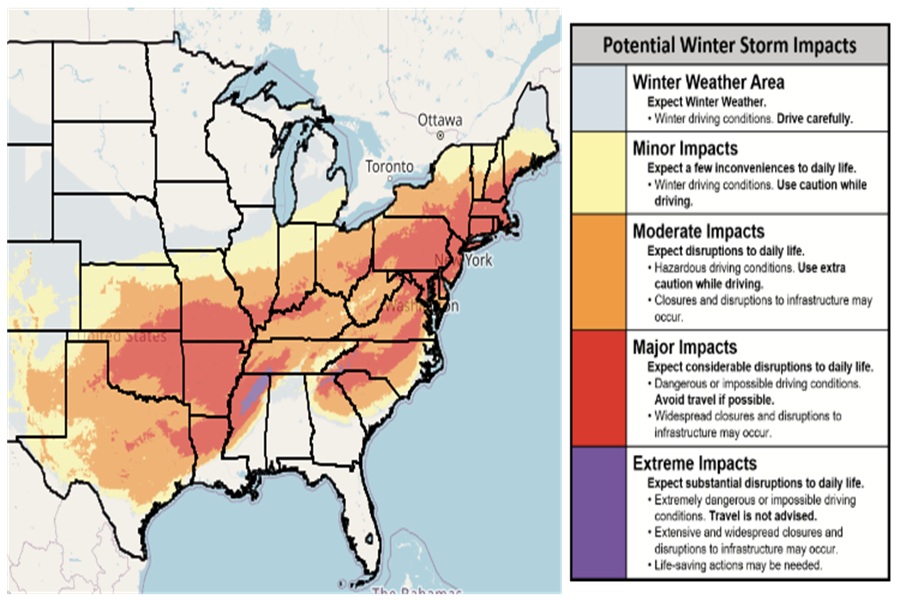
The National Weather Service is warning people to be prepared for a fierce winter storm from Texas to South Carolina and from Nebraska to Maine and all points in between; much of this area has been painted in red to signify major expected impacts from the storm.
The National Weather Service (NWS) uses their Winter Storm Severity Index (WSSI) to define the severity of expected impacts from the upcoming storm. The purpose of the Winter Storm Severity Index (WSSI) is to provide NWS partners and the general public with an indication of the level of winter precipitation (snow and ice) severity and its potential related societal impacts.
In shaded regions in gray, the NWS says to expect winter weather. “Drive carefully,” the NWS suggests, saying there will be winter driving conditions there.
In the yellow zone, minor impacts are expected. “Expect a few inconveniences to daily life,” says the NWS, adding that with winter driving conditions present, people should use caution.
In the orange zone, moderate impacts are expected where interruptions to daily life should be expected. With the presence of hazardous driving conditions, the NWS urges people to use extra caution while driving. Closures and disruptions to infrastructure are possible in this zone.
In the red zone, major impacts are expected. Here, people should expect considerable disruptions to daily life with dangerous or impossible driving conditions. “Avoid travel if possible,” warns the NWS for those in the red zone. Widespread closures and disruptions to infrastructure may occur.
In the purple and most extreme zone, extreme impacts are expected. Here, people should expect substantial disruptions to daily life with extremely dangerous or impossible driving conditions. “Travel is not advised,” warns the NWS about this zone. Extensive and widespread closures and disruptions to infrastructure may occur. Life-saving actions may be needed in this zone to rescue people from the extreme weather.
Currently, most of Arkansas, Oklahoma, southern Missouri, northern Louisiana, western North Carolina, central Virginia, most of Maryland and Pennsylvania, Delaware, Maryland, New Jersey, southern New York, Connecticut, Rhode Island, Massachussetts, and southern New Hampshire are in the “Major Impact” zone.
In northeastern Mississippi, “Extreme Impacts” are expected due to heavy accumulating ice which will create damage, power outages, and widespread road closures.
