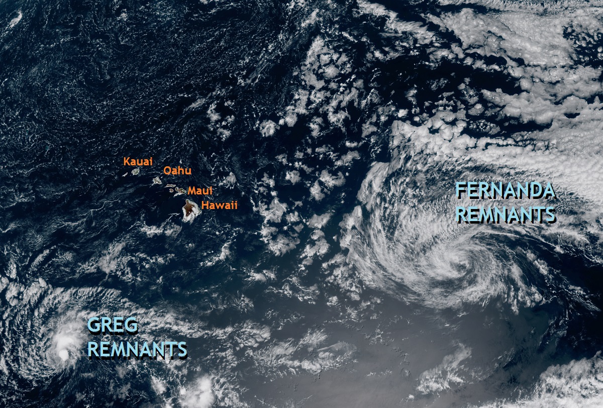
The remnants of Major Hurricane Fernanda are on their way to Hawaii while Maui continues to deal with the ongoing fire disaster there. On August 8, as Hurricane Dora passed well south of the islands, dry high pressure moved into the Aloha State, funneling fast, dry winds creating ideal fire weather conditions. On August 8, those fire conditions helped facilitate destructive fires on the Big Island of Hawaii and the nearby island of Maui. On Maui, fires continue to burn today in the wake of the catastrophic conditions that erupted on the 8th, destroying over 2,000 buildings and claiming the lives of at least 111 victims; more than 1,000 people are still accounted for, with most death and destruction occurring in the community of Lahaina on Maui’s west coast.

According to Maui officials, the Lahaina fire is 90% contained after burning 2,168 acres. Two other significant fires continue to burn on Maui: an Olinda fire, which is 85% contained with 1,081 acres burned, and a Kula fire which is 80% contained with 202 acres burned.
On the Big Island of Hawaii, fire fighters are also working fires there. A brush fire is currently burning in North Kona, closing the highway that exists between the town of Waimea and Kona on the west side of the island. Fire fighters continue to work over hot spots on a brush fire that broke out at the Mauna Kea Resort on August 8.
While Tropical Storm Greg faded away and moved well south of Hawaii yesterday, Fernanda, once a major Category 4 hurricane with 130 mph winds, is heading right for the islands of Hawaii and Maui. Fortunately, it is moving into Hawaii as a remnant system with some wind and a lot of rain, but not nearly the severity it had as a major hurricane. Nevertheless, even as just a fraction of its former self, Fernanda can create problems for Hawaii, especially on the Big Island of Hawaii and nearby Maui.
According to the Honolulu, Oahu office of the National Weather Service, the trade winds will increase beginning late Sunday and become breezy Monday through Tuesday as the remnant trough of former Tropical Cyclone Fernanda passes by to the south of the state. Deep tropical moisture associated with Fernanda will move into the eastern islands Sunday night, spread to the rest of the state Monday and Monday night. Some wet weather and locally heavy rainfall can be expected across windward areas, with leeward portions of the islands seeing some rain as well. The National Weather Service says there’s a plume of moisture with this system that’ll boost rainfall amounts. The greatest potential for heavy rain will be along windward areas, especially for Maui and the Big Island, while Leeward areas will see very little rain if any due to the rain shadowing effect from the terrain.
For now, there are no advisories of any kind for wind or rain across the state. That may change over the weekend as more is understood and forecast around these remnants of Fernanda.
After Fernanda passes through the state, the weather, as it relates to tropical cyclones, should quiet down in the Central Pacific. Both the National Hurricane Center and Central Pacific Hurricane Center expect no threats to Hawaii from tropical cyclones over the next 7 days; they also expect no new tropical cyclones to form within the Central Pacific hurricane basin during this time too.
The lack of tropical cyclone activity is a mixed blessing. While rainfall is welcome in areas dealing with drought in Hawaii, too much rain, especially in areas recovering from fire-related catastrophe, could hamper search and recovery endeavors.