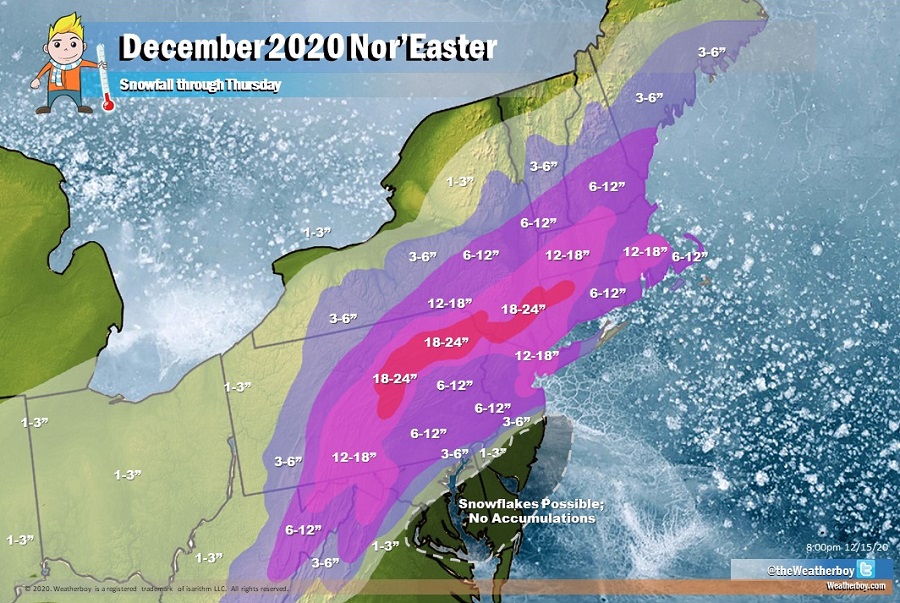
Weatherboy has updated its December 2020 Nor’Easter snow total forecast map to reflect new data and observations coming in throughout the Northeast and Mid Atlantic ahead of the Wednesday/Thursday event.
Upwards of 18-24″ is still expected across portions of central and northeastern Pennsylvania, extreme northwest New Jersey, portions of upstate New York, and into portions of northwest Connecticut. Some isolated 24-30″ amounts are also possible over the higher terrain of northeast Pennsylvania.
Some heavier snow is also expected to push slightly more north than initially expected, bringing healthy 3-6″ snowfall amounts to central New York, Vermont, New Hampshire, and southeastern Maine.

Below that area will be widespread 6-12″ amounts from Boston to New York to Philadelphia and many surrounding areas. In New York City and Boston, some amounts could come in at a foot or a few inches above that.
Snowfall rates within the 6-12″ and 12-18″ areas could be extremely heavy at times, with snowfall rates of 1-2″ per hour possible. This will make travel difficult if not impossible. Avoid travel in the heavy snow zones.
On the south side of the system, though, things are much more complicated. It appears some mild air will wrap around at the mid levels of the center of the storm. This means precipitation will fall as snow, melt into rain in the milder mid-levels, and re-freeze as sleet before it hits the surface. Because more sleet is expected than earlier, snowfall amounts have been cut down for central and southeastern Pennsylvania into west-central New Jersey.
Because the storm will be tracking over land rather than a few miles off-shore, it appears enough mild air will surge ahead of the storm to produce rain over southeastern New Jersey, the southern two-thirds of Delaware, and much of coastal Maryland. While cold air should wrap around and turn this precipitation back to snow, a “dry slot” should also develop, cutting-off precipitation-producing clouds in this pocket of the storm. As such, 10 miles south and east of the New Jersey Turnpike below exit 7 and 10 miles south of I-195 across central New Jersey, no accumulation is expected. While snowflakes are possible across southern New Jersey, much of Delaware, and most of eastern Maryland, they shouldn’t stick and create many problems.
In the very narrow band that stretches 10 miles south/east of the New Jersey Turnpike and 10 miles south of I-195 and 5 miles north of there, an extremely tight accumulation gradient will set-up. This means at around the 10 mile mark, there won’t be any accumulation of snow but at 5 miles north and west of these highways, there will be 6-12″ of snow. In between, that 0″ will fade up to 6-12″ over an extremely narrow brand, as depicted on the latest snowfall forecast map.
Lesser amounts are also expected for Baltimore and Washington, DC areas; 1-3″ is expected, with 3-6″ possible just north and west of these cities.
The update also reflects a tight gradient across Long Island; while little to no snow is expected on far eastern Long Island, heavy 12″+ totals are still expected in western Long Island new New York City. Central Long Island will see 6-12″.
In addition to the snow and rain, winds and coastal flooding will also become problematic in this storm.
Gusty northeast winds of 30-40mph with gusts of 50-60mph will whip across much of southern and eastern New Jersey and Delaware, with the strongest winds expected right at the coast. Gale to storm force northeast winds will also batter the coast, with seas building 10-15 feet in the Atlantic and up to 5 feet on the Delaware Bay. These winds will also help drive coastal flooding. Minor flooding is possible during Wednesday’s high tides with moderate flooding likely for the Thursday morning high tide. The areas hit the hardest will be the Jersey Shore and the Delaware Bay coast of Delaware and New Jersey.
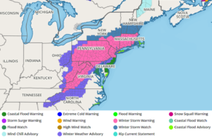
Due to the high winds, the National Weather Service has issued a High Wind Warning from 6pm Wednesday to 9am Thursday for eastern Monmouth, 6pm Wednesday to 2am Thursday for coastal Ocean and Atlantic, and 4pm Wednesday to 2am Thursday for Cape May county. The National Weather Service warns that people in High Wind Warning areas should “avoid being outside in forested areas and around trees and branches. If possible, remain in the lower levels of your home during the windstorm, and avoid windows. Use caution if you must drive.”