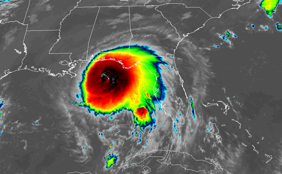
Meteorologists at the National Hurricane Center (NHC) in Miami, Florida have upgraded Sally to hurricane status, updating the last advisory to report maximum sustained winds have grown to 85 mph. Unfortunately, Sally is forecast to continue to gain strength until landfall sometime tomorrow. Life-threatening storm surge, flooding rains, damaging winds, rough surf, and numerous tornadoes are expected as Sally advances closer to the coast.
Data from a NOAA Hurricane Hunter aircraft investigating Sally indicate that the system has rapidly strengthened in recent hours. The estimated minimum central pressure is 985 mb or 29.09 inches and falling. The system is located at 28.6N 86.9W, roughly 135 miles east-southeast of the Mouth of the Mississippi River and about 175 miles southeast of Biloxi, Mississippi.
The forecast track has shifted a bit east than earlier thought; as such, watches and warnings have adjusted accordingly. Right now, there is a Storm Surge Warning in effect from Port Fourchon, Louisiana to the Alabama/Florida Border, Lake Pontchartrain, Lake Maurepas, and Lake Borgne, and for Mobile Bay. A Storm Surge Warning means there is a danger of life-threatening inundation, from rising water moving inland from the coastline, during the next 36 hours in the indicated locations. The NHC says, “This is a life-threatening situation. Persons located within these areas should take all necessary actions to protect life and property from rising water and the potential for other dangerous conditions. Promptly follow evacuation and other instructions from local officials.”
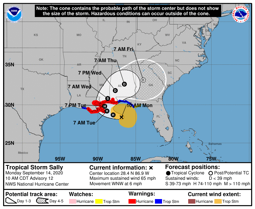
A Hurricane Warning is also in effect from Morgan City, Louisiana to the Alabama/Florida border, for Lake Pontchartrain and Lake Maurepas. The metropolitan New Orleans area is also under the Hurricane Warning. A Hurricane Warning means that hurricane conditions are expected somewhere within the warning area. Preparations to protect life and property should be rushed to completion.
A Tropical Storm Warning is in effect from the Alabama / Florida border to Indian Pass, Florida and from Intracoastal City, Louisiana to west of Morgan City. A Tropical Storm Watch is also in effect from Indian Pass, Florida to the Ochlockonee River in Florida. A Tropical Storm Warning means that tropical storm conditions are expected somewhere within the warning area within 36 hours. A Tropical Storm Watch means that tropical storm conditions are possible within the watch area.
Sally is moving toward the west-northwest near 6 mph. According to the NHC, this general motion is expected to continue today, followed by a decrease in forward speed and a turn toward the northwest tonight and a northward turn sometime on Tuesday. On the forecast track, the center of Sally will move over the north-central Gulf of Mexico today, approach southeastern Louisiana tonight, and make landfall in the hurricane warning area on Tuesday or Tuesday night. Afterward, Sally is expected to move slowly north-northeastward near the northern Gulf Coast through Wednesday.
Hurricane Sally will create a dangerous storm surge, dump extremely heavy rain, bring about damaging winds, spawn tornadoes, and create rough surf.
The combination of a dangerous storm surge and the tide will cause normally dry areas near the coast to be flooded by rising waters moving inland from the shoreline. The water could exceed 7-11 feet if the peak surge occurs at the time of high tide within a portion of the Storm Surge Warning area. Overtopping of local levees outside of the Hurricane and Storm Damage Risk Reduction System is possible where local inundation values may be higher than forecast. The deepest water will occur along the immediate coast in areas of onshore winds, where the surge will be accompanied by large and damaging waves. Surge-related flooding depends on the relative timing of the surge and the tidal cycle, and can vary greatly over short distances.
Hurricane force wind conditions are expected to begin within the Hurricane Warning area tonight. Tropical storm conditions are possible within the watch area today, and are expected to begin within the warning area later today.
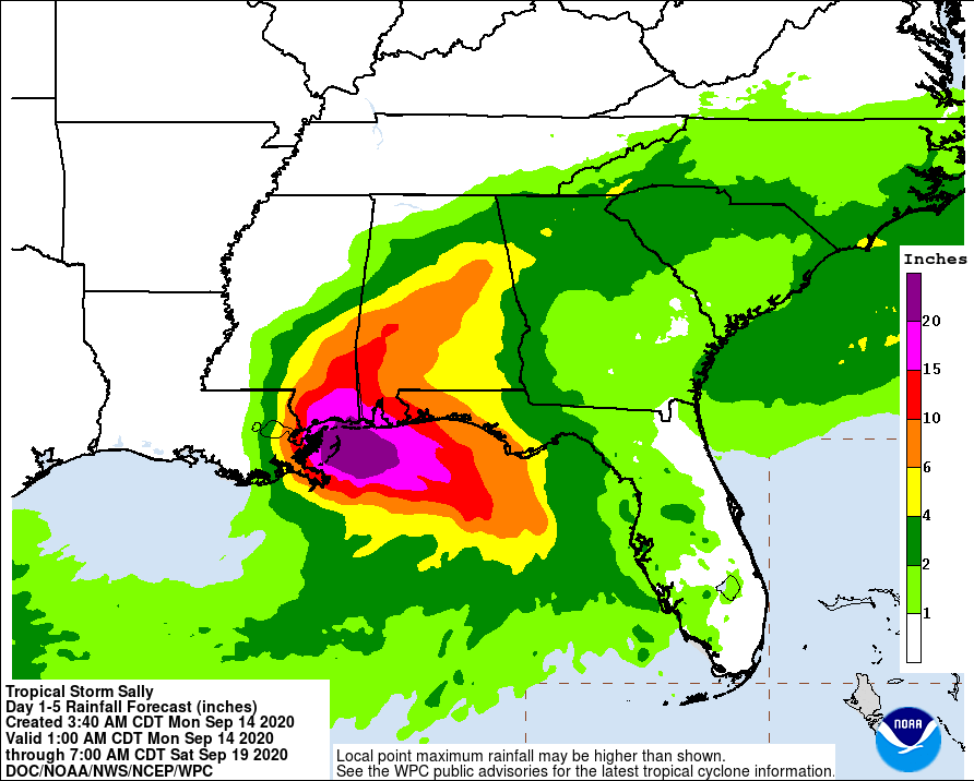
Hurricane Sally is expected to be a slow moving system as it approaches land, producing 8-16″ of rainfall with isolated amounts of 24″ possible over portions of the central Gulf Coast from the western Florida Panhandle to far southeast Louisiana through the middle of the week. Life-threatening flash flooding is likely. In addition, this rainfall will likely lead to widespread minor to isolated major flooding on area rivers.
Sally is forecast move farther inland early Wednesday and track into the Southeast with rainfall of 6-12″ possible across portions of inland southeast Mississippi and Alabama. Significant flash and urban flooding is likely, as well as widespread minor to moderate flooding on some rivers. Further heavy rain is then anticipated across portions of eastern Tennessee, northern Georgia and western Carolinas Thursday into Friday. Flash, urban, and minor river flooding is possible across this region.
Outer bands of Sally are expected to produce additional rainfall of 1-3″ across the Florida peninsula today. This rainfall may produce flash and urban flooding and prolong high flows and ongoing minor flooding on rivers across central Florida.
As with most landfalling tropical cyclones, tornadoes will form. While a few tornadoes could form today over coastal areas of the Florida Panhandle, Mississippi, Alabama, and extreme southeastern Louisiana, even more tornadoes are likely tomorrow and tomorrow night as the storm moves onto land.
Swells from Hurricane Sally will continue to affect areas from the west coast of the Florida peninsula westward through the coast of southeastern Louisiana during the next couple of days. These swells are likely to cause life-threatening surf and rip current conditions. Even expert swimmers and surfers should avoid the Gulf of Mexico waters until waters calm well after Sally’s passage.
