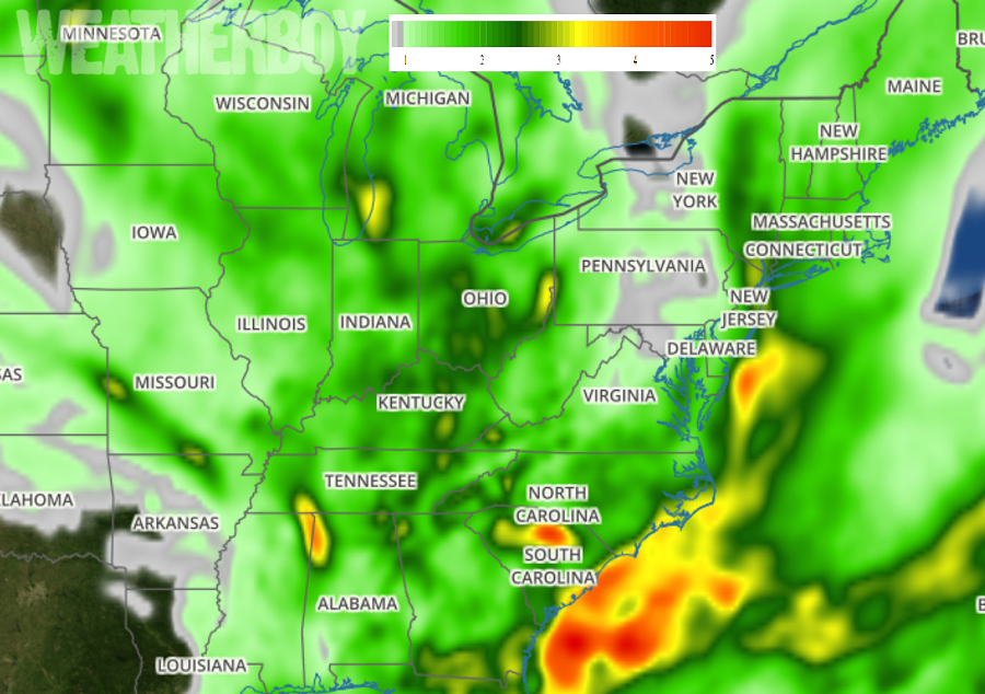
A prolonged period of wet weather will bring gray skies and damp conditions for a long stretch in the eastern U.S.; the unusual rainy period will be kicked-off by an even more unusual semi-tropical low pressure system due to impact the New York City metro region this weekend. Clear skies in place tonight will linger into tomorrow; residents here should enjoy the sunshine while they have it. Things will go downhill this weekend and stay wet and unsettled for the balance of the month. People in the eastern U.S. should become with flood terminology and the advisories that the National Weather Service may issue for flood threats in the coming days.
In the short-term, high pressure will shift off to the northeast as a developing coastal low moves northward in its wake. A strong upper-level trough is forecast to dig southward over the east-central U.S., with the upper low continuing to cut off. This atmospheric set-up will set the stage for a dark and damp stretch of days.
A semi-tropical low pressure system is forecast to move up the Jersey Shore Saturday into Saturday night impacting the New York City metro area early Sunday morning. Such a coastal low set-up is more common in November than it is in July. With summertime humidity levels and comparatively mild ocean temperatures to work with, this coastal storm will be a substantial soaker. While the system isn’t expected to take on tropical cyclone characteristics, it will produce very heavy rain and gusty winds. There’s also the threat of isolated thunderstorms as the system pushes into the Big Apple region. With ample clouds and rain, temperatures from Delaware to Connecticut and all places in between will see cooler than usual temperatures. Because rainfall amounts Saturday into Sunday could be over 2″, especially in New Jersey and New York, flooding threats will be of concern. With wind-whipped rains at the coast, coastal flooding may also become a concern on top of the fresh water flooding from rains.
By Sunday and into Monday, the coastal storm will continue to push north along the New England coast. The cut-off upper low located to the west of the I-95 corridor will remain stationary and begin to retrograde slightly on Tuesday. With a deep southerly flow filling in the gap along the coast from the departing coastal storm, soaking rains will return by Monday into early Tuesday. Another 2″ or more of rain could fall from this additional storm. On Wednesday and Thursday, as the cut-off low continues to retrograde and fill-in, another trough will begin to dig into the Great Lakes region. A developing surface low and cold front will slowly shift east towards the I-95 corridor by Thursday, acting as a forcing mechanism for more soaking rains.
With high pressure unable to take a hold of the east coast weather pattern, more waves of low pressure are likely along with more threats of rain they’ll bring. The pattern may be so gray and damp that it’s possible that parts of many East Coast states will see rain every day for the rest of the month beginning this weekend.