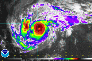
September 1 marks the first day of meteorological autumn, and the new season is kicking off with quite the beast in the east: Major Hurricane Irma. Major Hurricane Irma, a category 3 storm with maximum sustained winds of at least 120mph, is continuing its voyage across the central Atlantic. In about three days, it’ll be getting dangerously close to the Lesser Antilles; it’ll also be getting closer to a forecasting window that’ll allow meteorologists to better understand its future track. Guidance is in good agreement with where the storm will travel over the next 5 days; beyond that, lack of history of storms like it and questionable long-range forecast accuracy from computer forecast models creates more questions than answers.
While a landfall with the United States remains on the table, the timing, power, and location of such a collision course remain an unknown for now. While meteorologists are studying it and its local environment, eyes are also on the Pacific Ocean, the American west, and central Canada. All of these locations and the weather patterns over them will influence the atmospheric set-up around the US that Irma will eventually near. The location of the jet stream, high and low pressure systems, and other down-stream weather systems, will all play a role in where Irma goes and how strong it gets before it gets there. By the end of the Labor Day holiday weekend, there should be better agreement among forecast models and meteorologists with where Hurricane Irma could go.
For now, the entire US East Coast is at risk. While the Gulf of Mexico could also be at risk too, the threat of Irma impacting the US East Coast appears to be greater than the odds of it going into the Gulf of Mexico or curving out to sea. Until its future track is better known, residents in states that touch the Atlantic Ocean should make sure their Hurricane Action Plans are in order. In the days after the Labor Day holiday weekend, it may become necessary for some to put those plans into action.
Experts believe this Atlantic Hurricane Season, which runs through to the end of November, will be a busy one. Dr. Phil Klotzbach and the experts at Colorado State University updated their seasonal outlook again on July 5, showing a much more active than normal season expected. The National Oceanic and Atmospheric Administration (NOAA) also released their own forecast which shows this hurricane season to be likely more active than others.