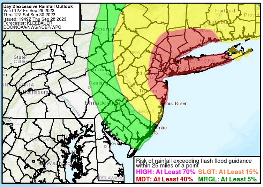
A serious flood threat exists today in portions of New Jersey and New York including the entire New York City metropolitan area where persistent heavy rain is creating significant flood concerns.
An area of low pressure, which merged with the remnants of Ophelia yesterday, is currently centered southeast of Cape Hatteras, North Carolina and will move northeastward slowly today and tonight. A strong upper-trough/closed low will move slowly toward the New York City metro area through the day today into tonight, helping to squeeze out plenty of moisture out of the atmosphere. The greatest threats will be near an inverted trough and coastal front, which is in the general New York City metropolitan area.
According to the National Weather Service, some of their computer forecast guidance is suggesting that as much as 5″ of rain can fall in some areas. With recent wet weather and saturated soils, there’s a high risk of flood conditions in the region.
There will be a sharp gradient on the west side of this system, so those close to the New Jersey / Pennsylvania state border won’t see nearly as much rain as those east of the NJ Turnpike and I-95 corridor a short distance to the east.
With plenty of clouds and rain, conditions will feel raw. An easterly flow will keep it cloudy and cool today, with temperatures struggling to get out of the upper 50’s and low 60’s for much of the New York City metro area. While there will be a sharp precipitation gradient to the west of New York City, there will also be a sharp temperature gradient to the south of the city. It’s possible portions of Delaware and the south Jersey Shore may break into the warm sector of this atmospheric set-up, allowing temperatures to possibly reach the low 70s there.

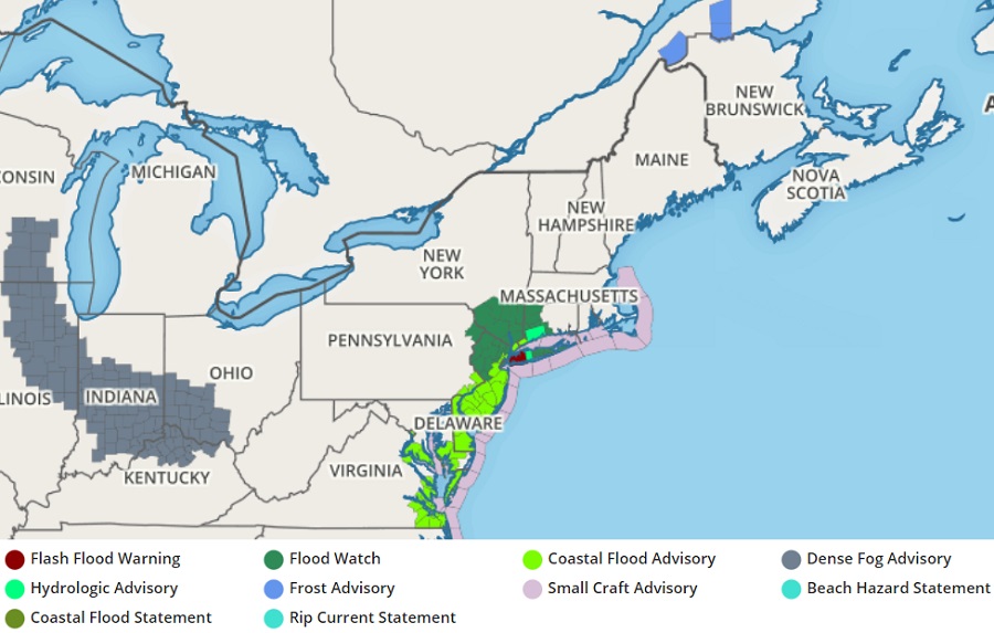
Due to the threat of floods, or the presence of floods now, many advisories and warnings are in effect in portions of the Mid Atlantic and Northeast.
A Flash Flood Warning is in effect now for Kings (Brooklyn), Nassau, and Queens counties in New York. There, doppler radar indicated thunderstorms producing heavy rain across the warned area. Between 0.5-2.5″ of rain have already fallen there, with expected rainfall rates of 1-1.5″/hour expected in the short-term, with additional rainfall totals of 1-3″ possible on top of what already fell. “Flash flooding is ongoing or expected to begin shortly,” the National Weather Service warns.
In most of Delaware, eastern Maryland, and much of New Jersey, a Flood Advisory is in effect. In coastal areas, a Coastal Flood Advisory is also in effect.
In northern New Jersey, southern Upstate New York, portions of Connecticut and eastern Long Island, a Flood Watch is also in effect.
“Turn around, don’t drown; never drive through flood waters,” the National Weather Service advises.